Deep Creek Valley

Last updated
Deep Creek Valley
DeepCreeksSnow.JPG
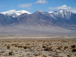
View southeasterly across valley, west flank
Deep Creek Mountains
USA Utah location map.svg
Red pog.svg
Deep Creek Valley
Deep Creek Valley in Utah
Length35 mi (56 km)N-S
Width4 mi (6.4 km)
Geography
CountryUnited States
StateUtah
Regions Great Basin and Great Salt Lake Desert
Counties Tooele and Juab
Communities Ibapah and Gold Hill
Borders on
Coordinates 40°10′37″N113°59′49″W / 40.1769°N 113.9969°W / 40.1769; -113.9969 Coordinates: 40°10′37″N113°59′49″W / 40.1769°N 113.9969°W / 40.1769; -113.9969
RiversDeep Creek and East Deep Creek

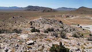
Deep Creek Valley is a 35-mile (56 km) long [1] valley located in southwest Tooele County at the Utah-Nevada border; the extreme south of the valley is in northwest Juab County. The valley parallels the west flank of the Deep Creek Range, both north-trending. In the north-northeast, its outlet widens into the southwest of the Great Salt Lake Desert region.

Valley Low area between hills, often with a river running through it.

A valley is a low area between hills or mountains typically with a river running through it. In geology, a valley or dale is a depression that is longer than it is wide. The terms U-shaped and V-shaped are descriptive terms of geography to characterize the form of valleys. Most valleys belong to one of these two main types or a mixture of them, at least with respect to the cross section of the slopes or hillsides.

Tooele County, Utah county in Utah, United States

Tooele County is a county in the U.S. state of Utah. As of the 2010 census, the population was 58,218. Its county seat and largest city is Tooele. The county was created in 1850 and organized the following year.

Utah A state of the United States of America

Utah is a state in the western United States. It became the 45th state admitted to the U.S. on January 4, 1896. Utah is the 13th-largest by area, 31st-most-populous, and 10th-least-densely populated of the 50 United States. Utah has a population of more than 3 million according to the Census estimate for July 1, 2016. Urban development is mostly concentrated in two areas: the Wasatch Front in the north-central part of the state, which contains approximately 2.5 million people; and Washington County in Southern Utah, with over 160,000 residents. Utah is bordered by Colorado to the east, Wyoming to the northeast, Idaho to the north, Arizona to the south, and Nevada to the west. It also touches a corner of New Mexico in the southeast.

Contents

The mountain range turns southwest and west in the south, and encloses the higher altitude terrain of the valley; here, the Goshute Indian Reservation lies in the mountains and the Deep Creek Valley's south; the community of Goshute is adjacent the valley; the reservation also extends westward into Nevada, into the east of the Antelope Valley.

Goshute, is a populated place, in Juab County, Utah. It lies at an elevation of 6,181 feet / 1,884 meters. Goshute if eight miles southeast of Eightmile, Nevada, the former site of Eightmile Station, (a Pony Express station, then a stagecoach station of the Overland Mail Company.

Antelope Valley (Elko-White Pine Counties)

The Antelope Valley adjacent to the Nevada/Utah state line, and located in southeast Elko County and northeast White Pine County, Nevada is a 70 mi (113 km) long endorheic valley. The valley curves around the Dolly Varden and Kinsley Mountains, and the Antelope Range.

Description

Deep Creek Valley follows the drainage of the north-flowing Deep Creek. In the valley's southern half, from Ibapah, UT on Deep Creek, at the northwest of the Deep Creek Range, and south, (East Deep Creek), to Goshute in the mountains, nine canyons and washes feed the Deep Creek system from the Deep Creek Range. Hills west, about 7-9 mi [2] of drainage, from Antelope Valley's east perimeter, washes flow east or northeast.

Deep Creek is stream in Tooele County, Utah. Deep Creek, heads in Deep Creek Valley at an elevation of 5,282 feet /1,610 meters, at the confluence of West Deep Creek and East Deep Creek at 40°01′51″N113°59′40″W. From there it flows northeast to dissipate in the Great Salt Lake Desert at an elevation of 4,255 feet / 1,297 meters. At times of high water the stream may flow to Tank Wash 11 miles north northeast of Gold Hill.

Ibapah, Utah Unincorporated community in Utah, United States

Ibapah is a small unincorporated community in far western Tooele County, Utah, United States, near the Nevada state line.

East Deep Creek is a stream tributary to Deep Creek in Tooele County, Utah.

The Deep Creek Valley is narrow, only about 4 mi, but follows circuitous routes around small hills, as well as Gold Hill northeast, and the Ferber Hills, northwest on the Nevada-Utah border. On Deep Creek, at the south of these two hill regions, and with the northwest convergence of the Deep Creek Range, is White Sage Flat. Washes and creeks converge here at the Flat, but Deep Creek continues on north-flowing.

Gold Hill, Utah Unincorporated community in Utah, United States

Gold Hill is a small, unincorporated community in far western Tooele County, Utah, United States, near the Nevada state line.

Ferber Hills is a range of hills in Elko County, Nevada and Tooele County, Utah. The range is formed in three parallel ridges of hills trending northwest to southeast. Its highest summit is Utah Peak, in the center of the central ridge of the range, at an elevation of 6,680 feet / 2,036 meters, just east of the state line in Tooele County, Utah. Its second highest Summit is Ferber Peak, that rises to and elevation of 6,601 feet / 2,012 meters, at the south end of the southernmost ridge of the range at 40°12′43″N114°03′18″W just west of the state line in Elko County, Nevada. The highest point in the smaller northernmost ridge is an unnamed summit at 40°17′12″N113°59′48″W with an elevation of 5,745 feet / 1,751 meters in Tooele County.

White Sage Flat is a flat in Elko County, Nevada and Tooele County, Utah.

The center of the valley is between White Sage Flat, and Ibapah, 40°02′12″N113°59′07″W / 40.03667°N 113.98528°W / 40.03667; -113.98528 to the south. [3]

See also

Related Research Articles

The Shoshone or Shoshoni are a Native American tribe with four large cultural/linguistic divisions:

Western Shoshone Great Basin native american people

The Western Shoshone comprise several Shoshone tribes that are indigenous to the Great Basin and have lands identified in the Treaty of Ruby Valley 1863. They resided in Idaho, Nevada, California, and Utah. The tribes are very closely related culturally to the Paiute, Goshute, Bannock, Ute, and Timbisha tribes.

Deep Creek Mountains

The Deep Creek Mountains, officially the Deep Creek Range, are a mountain range in the Great Basin located in extreme western Tooele County and Juab County, Utah, in the western United States. The range trends north-south,, and is composed of granite in its central highest portion. The valley to the east is Snake Valley and to the west is Deep Creek Valley. Nearby communities include Callao, Utah to the east and the community of Ibapah and the lands of the Confederated Tribes of the Goshute Reservation to the west.

Ferguson Desert plain in Millard County, Utah, United States

The Ferguson Desert is a small valley in the Hamlin-Snake Watershed of west-central Utah, southeast of the Snake Valley to the northwest, and is bound by the Burbank Hills to the west, the Tunnel Springs Mountains, Pine Valley, and Wah Wah Valley to the south, and the House Range to the north and east; Antelope Valley from the southwest is the southeast border of the Burbank Hills. It is named after James (Jim) Ferguson of Ibapah, Utah. He established a large ranch in the area. The term desert comes from the large hardpan that covers the area.

Goshute Valley

The Goshute Valley is an endorheic landform of the Great Basin. The towns of Oasis and Cobre are in the valley's north, and the central and north of the valley contains broken flatlands, with short washes draining from the surrounding mountain ranges.

Antelope Valley (Eureka County)

The Antelope Valley of southern Eureka County is a small 35 mi long valley, surrounded by four mountain ranges. Antelope Wash flows north, to endorheic flatlands at the valley's north end. Eureka, Nevada lies 20 mi east nestled among mountain ranges. From Eureka U.S. Route 50 travels west through the north end of the valley on a route to Austin.

Antelope Valley (southwest Millard County, Utah)

The Antelope Valley of southwest Millard County, Utah, United States, is a small 25-mile (40 km) long valley, adjacent the Ferguson Desert and 40 miles (64 km) southwest of Sevier Lake. The valley is just east of the Nevada border, with Snake Valley and the Burbank Hills. The other Antelope Valley of Utah occurs 165 miles (266 km) east in the Great Basin, in southeast Emery County and extending into adjacent Wayne County.

Hamlin Valley valley on both sides of the Nevada–Utah state line

Hamlin Valley is a mostly north-south trending valley of the Great Basin located on both sides of the Nevada–Utah state line. It is about 60 miles (97 km) long. Its north-northeast end point adjacent the state line, is the southwest start region of the Snake Valley.

Juab Valley valley in Utah, United States

The Juab Valley is a 40-mile (64 km) long valley located on the eastern edge of Juab County, Utah, United States.

Skull Valley (Utah)

Skull Valley, is a 40-mile (64 km) long valley located in east Tooele County, Utah, United States at the southwest of the Great Salt Lake. The valley trends north–south, but turns slightly northeast to meet Stansbury Bay,.

Cedar Valley (Iron County, Utah) valley in Iron County, Utah, United States

The Cedar Valley of Iron County, Utah, United States is a 25-mile (40 km) long valley located in the southeast of the county, against the Hurricane Cliffs which border the Cedar Mountains and the Markagunt Plateau.

Dugway Range

The Dugway Range is a 13-mile (21 km) long mountain range located in central-south Tooele County, Utah, on the Juab County north border.

Chinle Valley

Chinle Valley is a 65-mile (105 km) long valley located mostly in Apache County Arizona. Chinle Creek continues north into Utah to meet the San Juan River (Utah).

Peacock Mountains

The Peacock Mountains are a small, 26-mi (42 km) long mountain range in northwest Arizona, USA. The range is a narrow sub-range, and an extension north, at the northeast of the Hualapai Mountains massif, which lies to the southwest. The range is defined by the Hualapai Valley to the northwest, and north and south-flowing washes on its east border, associated with faults and cliffs; the Cottonwood Cliffs are due east, and are connected to the Aquarius Cliffs southward at the west perimeter of the Aquarius Mountains; the cliffs are a result of the Aquarius Fault, which is an extension southward from the Grand Wash Cliffs and Grand Wash Fault which crosses the Colorado River at Lake Mead, and the west perimeter of the Grand Canyon/Colorado Plateau.

Fifteenmile Creek is a tributary stream of East Deep Creek, in Juab County, Utah and Tooele County, Utah.

References

  1. Utah, DeLorme Atlas & Gazetteer, pp. 22-23, 30-31.
  2. DeLorme Atlas, p. 22.
  3. U.S. Geological Survey Geographic Names Information System: Deep Creek Valley