
Delmont is a borough in Westmoreland County, Pennsylvania. The population was 2,592 at the 2020 census.

Black Elk Peak is the highest natural point in the U.S. state of South Dakota and the Midwestern United States. It lies in the Black Elk Wilderness area, in southern Pennington County, in the Black Hills National Forest. The peak lies 3.7 mi (6.0 km) west-southwest of Mount Rushmore. At 7,244 feet (2,208 m), it is the highest summit in the United States east of the Rocky Mountains. Though part of the North American Cordillera, it is generally considered to be geologically separate from the Rocky Mountains.

This is a list of sites in Minnesota which are included in the National Register of Historic Places. There are more than 1,700 properties and historic districts listed on the NRHP; each of Minnesota's 87 counties has at least 2 listings. Twenty-two sites are also National Historic Landmarks.

This is a list of the National Register of Historic Places listings in Dakota County, Minnesota. It is intended to be a complete list of the properties and districts on the National Register of Historic Places in Dakota County, Minnesota, United States. Dakota County is located in the southeastern part of the U.S. state of Minnesota, bounded on the northeast side by the Upper Mississippi River and on the northwest by the Minnesota River. The locations of National Register properties and districts for which the latitude and longitude coordinates are included below, may be seen in an online map.

This list is of the properties and historic districts which are designated on the National Register of Historic Places or that were formerly so designated, in Hennepin County, Minnesota; there are 190 entries as of April 2023. A significant number of these properties are a result of the establishment of Fort Snelling, the development of water power at Saint Anthony Falls, and the thriving city of Minneapolis that developed around the falls. Many historic sites outside the Minneapolis city limits are associated with pioneers who established missions, farms, and schools in areas that are now suburbs in that metropolitan area.

This is a list of the National Register of Historic Places listings in Goodhue County, Minnesota. It is intended to be a complete list of the properties and districts on the National Register of Historic Places in Goodhue County, Minnesota, United States. The locations of National Register properties and districts for which the latitude and longitude coordinates are included below, may be seen in an online map.

This is a list of the National Register of Historic Places listings in Otter Tail County, Minnesota. It is intended to be a complete list of the properties and districts on the National Register of Historic Places in Otter Tail County, Minnesota, United States. The locations of National Register properties and districts for which the latitude and longitude coordinates are included below, may be seen in an online map.

This is a list of the National Register of Historic Places listings in Grand Forks County, North Dakota. This is intended to be a complete list of the properties and districts on the National Register of Historic Places in Grand Forks County, North Dakota, United States. The locations of National Register properties and districts for which the latitude and longitude coordinates are included below, may be seen in an online map.

This is a list of the National Register of Historic Places listings in Washington County, Minnesota. It is intended to be a complete list of the properties and districts on the National Register of Historic Places in Washington County, Minnesota, United States. The locations of National Register properties and districts for which the latitude and longitude coordinates are included below, may be seen in an online map.

This is a list of the National Register of Historic Places listings in Union County, South Dakota.

This is a list of the National Register of Historic Places listings in Pope County, Minnesota. It is intended to be a complete list of the properties and districts on the National Register of Historic Places in Pope County, Minnesota, United States. The locations of National Register properties and districts for which the latitude and longitude coordinates are included below, may be seen in an online map.

The First National Bank is a five-story building in Grand Forks, North Dakota, that was built in 1914–15 and listed on the National Register of Historic Places in 1982. It was built for the Scandinavian-American Bank, but has been identified as the First National Bank building since 1929.

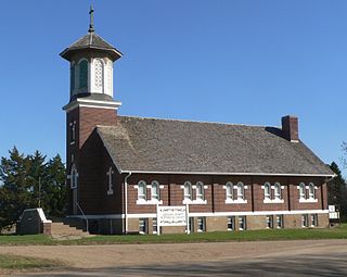
St. Wenceslaus Parish is a Catholic parish of the Roman Catholic Diocese of Sioux Falls in Tabor, South Dakota in the Midwestern United States. Its historic red brick church, built in 1898, was listed as St. Wenceslaus Catholic Church and Parish House on the National Register of Historic Places on December 13, 1984, as part of a "Thematic Nomination of Czech Folk Architecture of Southeastern South Dakota".
St. Augustine Church is a former Catholic church at the southeast corner of 6th and Main Streets in Dallas, South Dakota. It currently houses the Gregory County History Museum, operated by the Gregory County Historical Society.

Leavitt Farm is a historic farmstead at 103 Old Loudon Road in eastern Concord, New Hampshire. It consists of three 19th century farm buildings, including the c. 1847 Greek Revival farmhouse, a large c. 1888 shop and barn, and a 19th-century privy which has been converted into a well pumphouse. These buildings were built by Jonathan Leavitt, a farmer and blacksmith, and were later owned by his son Almah, a sign painter. In the 1980s the property was used by the Concord Coach Society as a headquarters and museum facility. The shop building in particular is notable for its adaptive reuse, and for its second floor ballroom space, an unusual location for that type of social space. The property was listed on the National Register of Historic Places in 1982.

The Dell Rapids Water Tower is a stone water tower located at 10th and Orleans Streets in Dell Rapids, South Dakota. The tower was built in 1894 to provide Dell Rapids with a civic water supply. The city decided to build the tower after an 1888 fire burned the south side of Main Street. The 45-foot (14 m) water tower is built with Sioux quartzite, a type of red-pink rock found in southern South Dakota, southwest Minnesota, and northwest Iowa. The tower provided water to Dell Rapids until 1960, when the city constructed a new tower. It is the only stone water tower remaining in South Dakota.
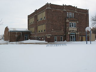
The Delmont Public School is a historic former school building at 205 West Third Street in Delmont, South Dakota. It is a three-story brick building, designed by the Nebraska firm of Grabe and Hellberg and built in 1923. Its styling is a vernacular rendition of Collegiate Gothic, with a central entrance framed by buttresses rising to an arch at the second level. The auditorium, added in 1938, extends from the rear of the main block.

The former Delmont State Bank is a historic bank building at 104 West Main Street in Delmont, South Dakota. It is a single-story brick structure, with a flat roof. Its main facade has three bays, two with plate glass windows of differing size on the left, and the main entry on the right. The facade is topped by a corbelled brick parapet, whose central section is topped by a concrete cap in which the year of construction, 1903, is incised. The Delmont State Bank was one of two banks established in Delmont in the early 1900s. The other folded in 1933, while the Delmont State Bank was merged into the First State Bank of Armour in 1966. After moving to larger facilities in 1976, the bank building was sold to the city for $1, and now houses city offices.
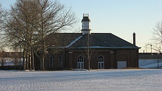
West Washington Street Pumping Station is a historic pumping station located in Indianapolis, Indiana. It was built in 1870, and is a one-story, rectangular brick building. It was modified to its present form after 1909, and is 2/3 of its original size. It has a slate hipped roof topped by a square central tower and features distinctive brick detailing, and arched openings. The building served as the city's only water pumping station until 1890.


