
Waukesha County is a county in the U.S. state of Wisconsin. As of the 2020 United States Census, the population was 406,978, making it the third-most populous county in Wisconsin. Its county seat and largest city is Waukesha.

Racine County is a county in southeastern Wisconsin. As of the 2020 census, its population was 197,727, making it Wisconsin's fifth-most populous county. Its county seat is Racine. The county was founded in 1836, then a part of the Wisconsin Territory. Racine County comprises the Racine metropolitan statistical area. This area is part of the Milwaukee-Racine-Waukesha combined statistical area. According to the U.S. Census Bureau, the county has an area of 792 square miles (2,050 km2), of which 333 square miles (860 km2) is land and 460 square miles (1,200 km2) (58%) is water. The county's unemployment rate was 5.6% in June 2021.

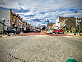
Muskego is a city in Waukesha County, Wisconsin, United States. As of the 2020 census, the city had a population of 25,032. Muskego is the fifth largest community in Waukesha County, Wisconsin. Muskego has a large Norwegian population. The name Muskego is derived from the Potawatomi Indian name for the area, "Mus-kee-Guaac", meaning sunfish. The Potawatomi were the original inhabitants of Muskego. There are three lakes within the city's boundaries.

New Berlin is a city located in eastern Waukesha County in the U.S. state of Wisconsin. The population was 40,451 at the 2020 census, making it the third-largest community in Waukesha County after the cities of Waukesha and Brookfield.

Mukwonago is a village in the U.S. state of Wisconsin. The population was 8,262 at the 2020 census. The village is located mostly within the Town of Mukwonago in Waukesha County, with a small portion extending into the Town of East Troy in Walworth County. Of its population, 8,040 are in Waukesha County and 222 are in Walworth County.
Delavan is a city in Walworth County, Wisconsin, United States. The population was 8,505 at the 2020 census. It is located 45 miles (72 km) southwest of Milwaukee. The city is located partially within the Town of Delavan, but the two entities are politically independent. Delavan is home to Delavan Lake which brings in a large number of tourists each year, and is also close to Lake Geneva, another popular tourist destination.

Oconomowoc is a city in Waukesha County, Wisconsin, United States. The name was derived from Coo-no-mo-wauk, the Potawatomi term for "waterfall." The population was 18,203 at the 2020 census. The city is partially adjacent to the Town of Oconomowoc and near the village of Oconomowoc Lake, Wisconsin.

Pewaukee is a city in Waukesha County, Wisconsin. The population was 15,914 at the 2020 census. The Village of Pewaukee, which was incorporated out of the town before it incorporated as a city, is surrounded by the city.

The Milwaukee metropolitan area is a major metropolitan area located in Southeastern Wisconsin, consisting of the city of Milwaukee and some of the surrounding area. There are several definitions of the area, including the Milwaukee–Waukesha–West Allis metropolitan area and the Milwaukee–Racine–Waukesha combined statistical area. It is the largest metropolitan area in Wisconsin, and the 39th largest metropolitan area in the United States.

The Eastern Ridges and Lowlands is a geographical region in the eastern part of the U.S. state of Wisconsin, between Green Bay in the north, and the border with Illinois in the south. Lake Michigan lies to the east of the region.
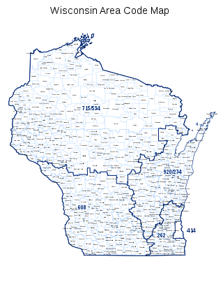
Area code 262 is a telephone area code in the North American Numbering Plan for the southeastern part of the U.S. state of Wisconsin. The numbering plan area comprises suburbs that are a part of the Milwaukee and Chicago metropolitan areas. The area code was created on September 25, 1999, in an area code split of area code 414.

The Bark River is a tributary of the Rock River, about 67.5 miles (108.6 km) long, in southeastern Wisconsin in the United States. Via the Rock River, it is part of the watershed of the Mississippi River. According to the Geographic Names Information System, it has also been known historically as the "Peelbark River". The Bark River rises in southern Washington County at Bark Lake In Richfield, WI and flows generally southwestwardly through Waukesha and Jefferson counties, past the communities of Hartland, Delafield, Summit Dousman and Rome, and through several small lakes. It joins the Rock River in Jefferson County just east of Fort Atkinson. In Jefferson County the Bark River collects the Scuppernong River.
Muskego High School is a comprehensive secondary school located in Muskego, Wisconsin. The school, administered by the Muskego-Norway School District, lies in southeast Waukesha County, in southeast Wisconsin. Muskego High School, related to a racism scandal in early 2023, the district stretches through the city of Muskego and nearby Norway in Racine County.
Wisconsin's 4th congressional district is a congressional district of the United States House of Representatives in Wisconsin, encompassing a part of Milwaukee County and including almost all of the city of Milwaukee, as well as its working-class suburbs of Cudahy, St. Francis, South Milwaukee, and West Milwaukee. Recent redistricting has added the Milwaukee County North Shore communities of Glendale, Shorewood, Whitefish Bay, Fox Point, Bayside, and Brown Deer to the district. It is currently represented by Gwen Moore, a Democrat.
James DeNoon Reymert was an American newspaper editor, mine operator, lawyer and politician. He was a pioneer settler in Wisconsin Territory, early elected official in the state of Wisconsin and founded the first Norwegian language newspaper to be published in the United States.

The Muskego Settlement was one of the first Norwegian-American settlements in the United States. Situated near today's Muskego, Wisconsin, the Muskego Settlement covered areas within what is now the town of Norway in Racine County, Wisconsin.

The 28th Senate District of Wisconsin is one of 33 districts in the Wisconsin State Senate. Located in southeast Wisconsin, the district comprises southwest Milwaukee County, southern Waukesha County, northwest Racine County, and northeast Walworth County. It includes all of the city of Muskego, as well as most of the cities of Greenfield and Franklin, and the villages of East Troy, Eagle, Greendale, Hales Corners, Mukwonago, and Waterford.
Menomonee used to be a town in Waukesha County, Wisconsin, United States.
Luther Parker was an American pioneer, teacher, and politician. He served as justice of the peace of the Republic of Indian Stream, located in what is now Pittsburg, New Hampshire. He later was an early settler in present-day Muskego, Wisconsin.
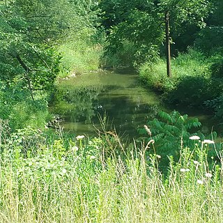
Jewel Creek is a stream in Muskego, Wisconsin. It flows from Linnie Lac to Little Muskego Lake, and is the primary tributary of Little Muskego Lake. Despite its relative proximity to Lake Michigan, Jewel Creek is part of the Mississippi River Watershed. Jewel Creek has a drainage area of 8.16 square miles. Between the years 2000 and 2003, its average flow rate was 6.52 cubic feet per second.


