
Racine County is a county in southeastern Wisconsin. As of the 2020 census, its population was 197,727, making it Wisconsin's fifth-most populous county. Its county seat is Racine. The county was founded in 1836, then a part of the Wisconsin Territory. Racine County comprises the Racine metropolitan statistical area. This area is part of the Milwaukee-Racine-Waukesha combined statistical area. According to the U.S. Census Bureau, the county has an area of 792 square miles (2,050 km2), of which 333 square miles (860 km2) is land and 460 square miles (1,200 km2) (58%) is water. The county's unemployment rate was 5.6% in June 2021.

Kenosha County is located in the southeastern corner of the U.S. state of Wisconsin. The population was 169,151 as of the 2020 census, making it the eighth most populous county in Wisconsin. The county shares the same name as the city of Kenosha, the fourth largest city in Wisconsin. Kenosha County is part of the Chicago metropolitan area, the fourth most-populous metropolitan area in North America. Kenosha County is situated on the southwestern shore of Lake Michigan.
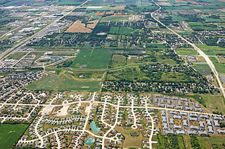
Mount Pleasant is a village in Racine County, Wisconsin, United States. It is located approximately 30 miles south of Milwaukee and 60 mi (97 km) north of Chicago. As of the 2020 census, the village's population was 27,732.

The Town of Norway is located in Racine County, Wisconsin, United States. The population was 7,916 at the 2020 census. The census-designated place of Wind Lake is in the town. The unincorporated communities of North Cape and Union Church are also located partially in the town.

Racine is a city in and the county seat of Racine County, Wisconsin, United States. It is located on the shore of Lake Michigan at the mouth of the Root River. Racine is situated 22 miles (35 km) south of Milwaukee and approximately 60 miles (100 km) north of Chicago. It is the principal city of the US Census Bureau's Racine metropolitan area. The Racine metropolitan area is, in turn, counted as part of the Milwaukee combined statistical area. As of the 2020 U.S. Census, the city had a population of 77,816, making it the fifth-most populous city in Wisconsin. In January 2017, it was rated "the most affordable place to live in the world" by the Demographia International Housing Affordability survey.

Raymond is a village in Racine County, Wisconsin, United States. The population was 3,926 at the 2020 census. The unincorporated communities of Kneeland and Raymond are located in the town, as was the ghost town of Raymond Center. The unincorporated communities of North Cape and Union Church are also located partially in the town.

Sturtevant is a village in Racine County, Wisconsin, United States. The population was 6,919 at the 2020 census.

Burlington is a city in Racine and Walworth counties in the U.S. state of Wisconsin, with the majority of the city located in Racine County. The population of the city was 11,047 as of the 2020 census.

The Milwaukee metropolitan area is a major metropolitan area located in Southeastern Wisconsin, consisting of the city of Milwaukee and some of the surrounding area. There are several definitions of the area, including the Milwaukee–Waukesha–West Allis metropolitan area and the Milwaukee–Racine–Waukesha combined statistical area. It is the largest metropolitan area in Wisconsin, and the 39th largest metropolitan area in the United States.
North Cape, Northern Cape, or Nordkapp may refer to:

Kansasville is an unincorporated community in Racine County, Wisconsin, United States. The area is a part of the Town of Dover. The area has also been referred to as Brighton or Eagle Lake, Wisconsin.

State Trunk Highway 11 is a state highway running east–west across southern Wisconsin. The highway connects Dubuque, Iowa with the cities of Janesville, Racine and Elkhorn. Most of the route is two-lane road with the exception of an expressway bypass of Monroe, a multilane bypass of Janesville, a section where it is concurrent with I-39 and I-90, a combined freeway/divided highway bypass of Burlington to the south, where it is partially concurrent with WI 36 and WI 83, and urban multilane highway in the greater Racine area.

State Trunk Highway 20 is a 42.95-mile (69.12 km) state highway in Walworth and Racine counties in southeastern Wisconsin, United States. The route is a short connector that bridges the city of Whitewater and points west via U.S. Highway 12 (US 12) with East Troy, Waterford and Racine. WIS 20 is a two-lane surface road with various four-lane roads within cities.
Husher is a former unincorporated community located within the Village of Caledonia, in Racine County, Wisconsin, United States.
It is generally known as the area extending in all directions between 1/2 mile to 1 mile from the intersection of Wisconsin Highway 38 and Nicholson Road.
This intersection is 2 miles south of the Racine/Milwaukee County line.
Caldwell is an unincorporated community located in the town of Waterford, Racine County, Wisconsin, United States. The community was named for settlers Joseph and Tyler Caldwell, two brothers from Vermont who arrived in the area around 1836.
Ives Grove is an unincorporated community located in the town of Yorkville, Racine County, Wisconsin, United States. The Ives Grove Golf Course and Country Club, the Racine Convention and Tourism Center, and Evans Park are all located nearby.
Little Falls is an unincorporated community located in the town of Alden, Polk County, Wisconsin, United States. Little Falls is located at the junction of County Highways C and PP 3.6 miles (5.8 km) southwest of Amery. The Apple River flows through Little Falls and was once dammed where County Road C now crosses the river.
Honey Lake is an unincorporated community located in Racine and Walworth Counties, Wisconsin, United States.

Adam Apple was a Kingdom of Bavaria born immigrant to the United States who was a farmer, carpenter, and politician. A Democrat, he served four years in the Wisconsin State Senate and seven years in the State Assembly representing Racine County.
The global COVID-19 pandemic struck the U.S. state of Wisconsin in early February 2020. Although Wisconsin has to date experienced 144 deaths per 100,000 residents, significantly fewer than the US national average of 196 deaths, COVID-19 was one of the three leading causes of death in Wisconsin in 2020. On August 25, 2021, Wisconsin public health authorities reported 7 day averages of 1,417 new cases and 236 probable cases per day, an increase of greater than 15 fold since late June 2021. This brings the cumulative total of COVID-19 cases in Wisconsin to 651,338. The state's death toll is 7,558, with 30 new deaths over the previous 7 days. As of August 25, 2021, 12.41% of Wisconsin's residents have been positively diagnosed with COVID-19, the 20th highest per-capita case rate among all US states. January 16's 128 COVID-19 deaths set a new single day record for Wisconsin.

