Burlington (town), Wisconsin

Last updated

Town of Burlington, Wisconsin
WIMap-doton-Burlington-town.png
Location of the Town of Burlington (town), Wisconsin
Coordinates: 42°40′11″N88°15′42″W / 42.66972°N 88.26167°W / 42.66972; -88.26167
Country Flag of the United States.svg  United States
State Flag of Wisconsin.svg  Wisconsin
County Racine
Area
  Total35.9 sq mi (93.0 km2)
  Land34.5 sq mi (89.4 km2)
  Water1.4 sq mi (3.7 km2)
Elevation
[1]
751 ft (229 m)
Population
 (2020)
  Total6,465
  Density185.0/sq mi (71.4/km2)
Time zone UTC-6 (Central (CST))
  Summer (DST) UTC-5 (CDT)
Area code 262
FIPS code 55-11225 [2]
GNIS feature ID1582889 [1]

The Town of Burlington is located in Racine County, Wisconsin. The population was 6,465 at the 2020 census. The City of Burlington is located mostly within the town. The census-designated places of Bohners Lake, and Browns Lake are located within the town. The unincorporated community of Cedar Park is also located in the town.

Contents

Geography

According to the United States Census Bureau, the town has a total area of 35.9 square miles (93.1 km2), of which, 34.5 square miles (89.4 km2) of it is land and 1.4 square miles (3.7 km2) of it (3.92%) is water.

Demographics

As of the census [2] of 2000, there were 6,384 people, 2,354 households, and 1,800 families residing in the town. The population density was 185.0 people per square mile (71.4/km2). There were 2,797 housing units at an average density of 81.0 per square mile (31.3/km2). The racial makeup of the town was 97.65% White, 0.08% Black or African American, 0.05% Native American, 0.42% Asian, 0.97% from other races, and 0.83% from two or more races. 2.05% of the population were Hispanic or Latino of any race.

There were 2,354 households, out of which 35.1% had children under the age of 18 living with them, 65.1% were married couples living together, 7.5% had a female householder with no husband present, and 23.5% were non-families. 18.3% of all households were made up of individuals, and 7.7% had someone living alone who was 65 years of age or older. The average household size was 2.68 and the average family size was 3.07.

In the town, the population was spread out, with 25.8% under the age of 18, 6.9% from 18 to 24, 28.9% from 25 to 44, 26.6% from 45 to 64, and 11.8% who were 65 years of age or older. The median age was 38 years. For every 100 females, there were 100.1 males. For every 100 females age 18 and over, there were 98.5 males.

The median income for a household in the town was $57,891, and the median income for a family was $62,168. Males had a median income of $43,020 versus $26,386 for females. The per capita income for the town was $24,203. About 0.4% of families and 2.2% of the population were below the poverty line, including 1.1% of those under age 18 and 4.6% of those age 65 or over.

Related Research Articles

<span class="mw-page-title-main">Sylvan Springs, Alabama</span> Town in Alabama, United States

Sylvan Springs is a town in Jefferson County, Alabama, United States, located northwest of the Birmingham suburb of Pleasant Grove. It incorporated on May 22, 1957. At the 2010 census the population was 1,542, up from 1,465 in 2000. This area was damaged by an F5 tornado on April 8, 1998, including the First United Methodist Church of Sylvan Springs.

<span class="mw-page-title-main">Lost Hills, California</span> Census-designated place in California, United States

Lost Hills is a census-designated place (CDP) in Kern County, California, United States. Lost Hills is located 42 miles (68 km) west-northwest of Bakersfield, at an elevation of 305 feet (93 m). The population was 2,412 at the 2010 census, up from 1,938 at the 2000 census.

<span class="mw-page-title-main">Media, Illinois</span> Village in Illinois, United States

Media is a village in Henderson County, Illinois, United States. The population was 107 at the 2010 census, down from 130 at the 2000 census. It is part of the Burlington, IA–IL Micropolitan Statistical Area.

<span class="mw-page-title-main">Stronghurst, Illinois</span> Village in Illinois, United States

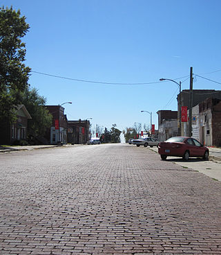
Stronghurst is a village in Henderson County, Illinois, United States. The population was 883 at the 2010 census. It is part of the Burlington, IA–IL Micropolitan Statistical Area.

<span class="mw-page-title-main">Burlington, Indiana</span> Town in Indiana, United States

Burlington is a town in Burlington Township, Carroll County, Indiana, United States. The population was 603 at the 2010 census. It is part of the Lafayette, Indiana Metropolitan Statistical Area. State Road 22 connects it to Kokomo.

<span class="mw-page-title-main">Brookston, Indiana</span> Town in Indiana, United States

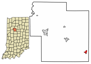
Brookston is a town in Prairie Township, White County, in the U.S. state of Indiana. The population was 1,554 as of the 2010 United States Census.

<span class="mw-page-title-main">Hedrick, Iowa</span> City in Iowa, United States

Hedrick is a city in Keokuk County, Iowa, United States. The population was 728 at the time of the 2020 census.

<span class="mw-page-title-main">Burlington, Kansas</span> City in Coffey County, Kansas, United States

Burlington is a city in and the county seat of Coffey County, Kansas, United States. As of the 2020 census, the population of the city was 2,634.

Burlington is a town in Penobscot County, Maine, United States. It is part of the Bangor Metropolitan Statistical Area. The population was 373 at the 2020 census.

<span class="mw-page-title-main">Burlington Junction, Missouri</span> City in Missouri, United States

Burlington Junction is a city in Nodaway County, Missouri, United States. The population was 521 at the 2020 census.

<span class="mw-page-title-main">Altamahaw, North Carolina</span> Census-designated place in North Carolina, United States

Altamahaw is a census-designated place (CDP) in Alamance County, North Carolina, United States. It is part of the Burlington, North Carolina Metropolitan Statistical Area. As of the 2010 census it had a population of 347. The community was listed as Altamahaw-Ossipee at the 2000 census, at which time the population was 996. The town of Ossipee incorporated in 2002 and currently has a population of 543. The remainder of the territory was reassigned as the Altamahaw CDP.

<span class="mw-page-title-main">Des Lacs, North Dakota</span> City in North Dakota, United States

Des Lacs is a city in Ward County, North Dakota, United States. The population was 185 at the 2020 census. It is part of the Minot Micropolitan Statistical Area. Des Lacs was founded in 1888, named after the Riviere de Lacs, from the French for "River [of] The Lakes."

<span class="mw-page-title-main">Pringle, South Dakota</span> Town in South Dakota, United States

Pringle is a town in Custer County, South Dakota, United States. The population was 109 at the 2020 census.

<span class="mw-page-title-main">Rome, Adams County, Wisconsin</span> Town in Wisconsin, United States

The Town of Rome is located in Adams County in the U.S. state of Wisconsin. The population was 2,720 at the 2010 census. The census-designated places of Lake Arrowhead, Lake Camelot, and Lake Sherwood are located in the town. The unincorporated communities of New Rome and Rome are also located in the town.

<span class="mw-page-title-main">Bagley, Wisconsin</span> Village in Wisconsin, United States

Bagley is a village in Grant County in the U.S. state of Wisconsin located on the Upper Mississippi River about 9 miles (15 km) south of Prairie du Chien, Wisconsin. The population was 379 at the 2010 census. It is a popular riverside destination in the summer, when the population can quadruple. The village was named for Vermont natives Alfred and Mary Bagley, who owned the site.

<span class="mw-page-title-main">Day, Wisconsin</span> Town in Wisconsin, United States

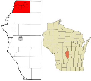
Day is a town in southwest Marathon County, Wisconsin, United States. It is part of the Wausau, Wisconsin Metropolitan Statistical Area. The population was 1,085 at the 2010 census. The unincorporated community of Rozellville is located in the town. The unincorporated community of Rangeline is also located partially in the town.

<span class="mw-page-title-main">Burlington, Wyoming</span> Town in Wyoming, United States

Burlington is a town in Big Horn County, Wyoming, United States. The population was 288 at the 2010 census.

The Town of Potosi is located in Grant County, Wisconsin, United States. The population was 831 at the 2000 census. The Village of Potosi and the unincorporated communities of British Hollow, Buena Vista, Rockville, and Van Buren are located in the town.

<span class="mw-page-title-main">Janesville (town), Wisconsin</span> Town in Wisconsin, United States

The Town of Janesville is a located in Rock County, Wisconsin, United States. The population was 3,665 at the 2020 census. The City of Janesville is located to the southeast of and adjacent to the town. The unincorporated communities of Anderson and Leyden are located in the town.

<span class="mw-page-title-main">Breese Township, Clinton County, Illinois</span> Township in Illinois, United States

Breese Township is one of fifteen townships in Clinton County, Illinois, USA. As of the 2020 census, its population was 5,594 and it contained 2,410 housing units.

References

  1. 1 2 "US Board on Geographic Names". United States Geological Survey. October 25, 2007. Retrieved January 31, 2008.
  2. 1 2 "U.S. Census website". United States Census Bureau . Retrieved January 31, 2008.