| Denvilles | |
|---|---|
 | |
 Denvilles Location within Hampshire | |
| OS grid reference | SU725065 |
| District | |
| Shire county | |
| Region | |
| Country | England |
| Sovereign state | United Kingdom |
| Post town | HAVANT |
| Postcode district | PO9 |
| Dialling code | 023 |
| Police | Hampshire and Isle of Wight |
| Fire | Hampshire and Isle of Wight |
| Ambulance | South Central |
| UK Parliament | |
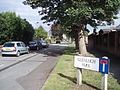
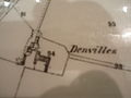
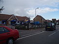
Denvilles is a locality within Havant to the north of Warblington railway station. [1] In 1877 it consisted of a solitary farm [2] but by 1897 there were several roads of detached residences. [3] Slowly the area grew, and in the 1960s it doubled in size as smaller housing estates for private ownership were built. [4] The area has a small convenience store but the adjoining satellite health centre moved in July to centralised premises elsewhere. [5] The Borough Council [6] designates the area UA2: not a priority for extra investment. [7]