Mount Charleston, officially named Charleston Peak, at 11,916 feet (3,632 m), is the highest mountain in both the Spring Mountains and Clark County, in Nevada, United States. It is the eighth-highest mountain in the state. Well separated from higher peaks by large, low basins, it is the most topographically prominent peak in Nevada, and the eighth-most-prominent peak in the contiguous United States. It is one of eight ultra-prominent peaks in Nevada. It is located about 35 miles (56 km) northwest of Las Vegas within the Mount Charleston Wilderness, which is within the Spring Mountains National Recreation Area of the Humboldt-Toiyabe National Forest.

The Anaconda-Pintler Wilderness is located in southwestern Montana, in the northwestern United States. It runs for 40 miles (65 km) along both sides of the crest of the Anaconda Range, covering almost 250 square miles (640 km2). To the north are the Sapphire Mountains, and to the south is the Big Hole Valley. Elevations range from about 5000 feet up to 10,793 feet at West Goat Peak. West Pintler Peak, located in a more commonly visited area, rises to 9894 feet. Visitors can most easily access this area via trailheads at Pintler Lake to the south, and at Lutz Creek and Moose Lake to the north. The wilderness lies in parts of Deer Lodge, Granite, Ravalli, and Beaverhead counties.

The Trinity Alps Wilderness is a 525,627-acre (2,130 km2) designated wilderness located in northern California, roughly between Eureka and Redding. It is jointly administered by Shasta-Trinity, Klamath, and Six Rivers National Forests. About 4,623 acres (18.71 km2) are administered by the Bureau of Land Management. The wilderness is located in the Salmon and Scott Mountains, subranges of the Klamath Mountains region. The high, granitic and ultramafic peaks of the eastern half of the wilderness area are known as the Trinity Alps. Granite peaks at the core of the area are known as the White Trinities, reddish ultramafic peaks in the southeast are known as the Red Trinities, and the forested mountains in the western half of the wilderness are known as the Green Trinities.

Handies Peak is a high and prominent mountain summit of the San Juan Mountains range in the Rocky Mountains of North America. The 14,058-foot (4284.8 m) fourteener is located in the Bureau of Land Management Handies Peak Wilderness Study Area, 13.4 miles (21.5 km) southwest by west of the Town of Lake City in Hinsdale County, Colorado, United States.

Pilot Peak is the highest mountain in the Pilot Range in extreme eastern Elko County, Nevada, United States. It is the most topographically prominent peak in Elko County and the fourth-most prominent peak in Nevada. The peak is on public land administered by the Bureau of Land Management and thus has no access restrictions.
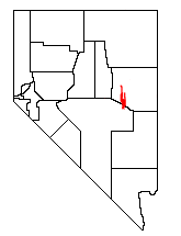
The White Pine Range is a group of mountains in southern White Pine County, in eastern Nevada. The range runs for approximately 51 miles (82 km) from Beck Pass in the north to Currant Pass in the south. To the west of the range are the Duckwater (Shoshone) tribal lands and the northern arm of large Railroad Valley. To the east are Jakes Valley and the northern part of the long White River Valley. To the south are the Horse and Grant Ranges.

Mount Moriah is a 12,072-foot (3,680 m) mountain in the northern Snake Range of eastern White Pine County, Nevada, United States. It is the fifth-highest mountain in the state, and also ranks as the ninth-most topographically prominent peak in the state. It is located in the Mount Moriah Wilderness administered by the Humboldt-Toiyabe National Forest.

Mount Jefferson is the highest mountain in both the Toquima Range and Nye County in Nevada, United States. It is the sixth highest mountain in the state. As the high point of a range which is well separated from other ranges by low basins, Mount Jefferson has a high topographic prominence of 5,861 feet (1,786 m). This makes it the most prominent peak in Nye County and the third most prominent peak in Nevada. For similar reasons, it is also the highest mountain for over 90 miles in all directions. It is located about 50 miles (80 km) northeast of the county seat of Tonopah within the Alta Toquima Wilderness of the Humboldt-Toiyabe National Forest, near the smaller towns of Carvers and Round Mountain. Three distinct summits are located on a broad area of subalpine tundra: North Summit rises to 11,820 feet (3,603 m), Middle Summit to 11,692 feet (3,564 m), and South Summit to 11,949 feet (3,642 m). During the Pleistocene, alpine glaciers eroded several cirques east of the summit plateau.
The Jackson Mountains are a north-northeast trending mountain range in southwestern Humboldt County, Nevada. The range is flanked on the west by the Black Rock Desert and the Black Rock Range beyond. To the north across the Quinn River and Nevada State Route 140 lie the Bilk Creek Mountains. To the northeast across Kings River Valley is the Double Mountains and to the east are the Sleeping Hills. To the southeast and south lie the Eugene and Kamma Mountains. The ghost town of Sulphur lies just southwest of the pass between the Jackson and Kamma ranges. Nevada State Route 49 and the Union Pacific railroad Feather River Route traverse this pass.

Weepah Spring Wilderness is a 51,480-acre (20,830 ha) wilderness area in Lincoln and Nye Counties, in the U.S. state of Nevada. The Wilderness lies approximately 35 miles (56 km) north of the town of Alamo and is administered by the U.S. Bureau of Land Management.
The New Pass Range is a mountain range in Lander and Churchill counties of Nevada. The range is a north-south trending range which straddles the Lander-Churchill county boundary for about 16 miles (26 km). The highest peak New Pass Peak has an elevation of 9,003 feet (2,744 m). US Route 50 crosses New Pass Summit on the south end of the range between Austin to the east and Fallon on to the west. The range was named from an early settler's belief that his route through the mountains was a "new pass" through the area.

The Pueblo Mountains are a remote mountain range in the United States located mostly in southeastern Oregon and partially in northwestern Nevada. The highest point in the range is Pueblo Mountain. The dominant vegetation throughout is grasses and big sagebrush; however, there are meadows with cottonwood, aspen, and willow groves along some stream drainages. Most of the range is public land administered by the Bureau of Land Management. There is very little human development in the Pueblo Mountains, and most visitors come for backpacking cross-country, camping, and hunting.

The Trout Creek Mountains are a remote, semi-arid Great Basin mountain range mostly in southeastern Oregon and partially in northern Nevada in the United States. The range's highest point is Orevada View Benchmark, 8,506 feet (2,593 m) above sea level, in Nevada. Disaster Peak, elevation 7,781 feet (2,372 m), is another prominent summit in the Nevada portion of the mountains.

Diamond Peak is both the highest and most topographically prominent mountain in both the Diamond Mountains and Eureka County, in Nevada, United States. It ranks thirty-ninth among the most topographically prominent peaks in the state. The peak is located on the border of Eureka County and White Pine County, about 12 miles northeast of the small town of Eureka, between the south end of Diamond Valley and the central portion of Newark Valley. It is on public land administered by the Bureau of Land Management and thus has no access restrictions.

Mount Lewis is the highest peak in the Shoshone Range in Lander County, Nevada, United States. It is the most topographically prominent peak in Lander County and the twentieth-most prominent peak in Nevada. The peak is located about 14 miles southeast of the town of Battle Mountain. An FAA Long Range Air Route Surveillance Radar station is located just west of the summit. The peak is on public land administered by the Bureau of Land Management and thus has no access restrictions.

Star Peak is both the highest and most topographically prominent mountain in both the Humboldt Range and Pershing County in Nevada, United States. It is the sixth-most topographically prominent peak in Nevada. The peak is on public land administered by the Bureau of Land Management and has no access restrictions.
Mount Augusta is the highest mountain in the Clan Alpine Mountains of Churchill County in Nevada, United States. It is the most topographically prominent peak in Churchill County and ranks nineteenth among the most topographically prominent peaks in Nevada. The peak is on public land administered by the Bureau of Land Management and thus has no access restrictions.
Mount Siegel is the highest mountain in the Pine Nut Mountains of Douglas County in Nevada, United States. It is the most topographically prominent peak in Douglas County and ranks forty-sixth among the most topographically prominent peaks in Nevada. The peak is on public land administered by the Bureau of Land Management and thus has no access restrictions.
Mormon Peak is the highest mountain in the Mormon Mountains of Lincoln County in Nevada, United States. It is the most topographically prominent peak in Lincoln County and ranks twenty-fourth among the most topographically prominent peaks in Nevada. The peak is on public land administered by the Bureau of Land Management and thus has no access restrictions.
Virginia Peak is the highest mountain in the Pah Rah Range of Washoe County in Nevada, United States. It is the most topographically prominent peak in Washoe County and ranks thirty-sixth among the most topographically prominent peaks in Nevada. The peak is on public land administered by the Bureau of Land Management and thus has no access restrictions. A National Weather Service NEXRAD doppler weather radar station is located on the summit.