
Manipal is a suburb and university town within Udupi, in coastal Karnataka, India. Manipal is located five kilometres away from the centre of Udupi City, in Udupi District, Karnataka (state) in south western India. It is administered by the Udupi City Municipality. The suburb is located in coastal Karnataka, 62 km north of Mangalore and 8 km east of the Arabian Sea. From its location on a plateau, at an altitude of about 75 metres above sea level, it commands a panoramic view of the Arabian Sea to the west and the Western Ghats to the east.

Raichur District is an administrative district in the Indian state of Karnataka. It is located in the northeast part of the state and is bounded by Yadgir district in the north, Bijapur and Bagalkot district in the northwest, Koppal district in the west, Bellary district in the south, Jogulamba Gadwal district of Telangana and Kurnool district of Andhra Pradesh in the east.

Bijapur district, officially known as Vijayapura district, is a district in the state of Karnataka in India. The city of Bijapur is the headquarters of the district, and is located 530 km northwest of Bangalore. Bijapur is well known for the great monuments of historical importance built during the Adil Shahi dynasty.
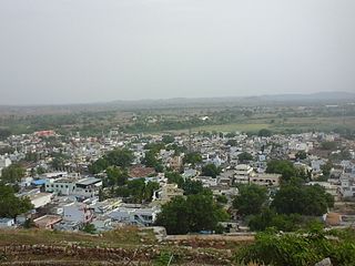
Manvi is a City in the Raichur district of the Indian state of Karnataka. It is the municipal headquarters of the Manvi taluk. Manvi Police Station stood fifth in the list of top 10 best police station across the country.

Tumkur is a city located in the southern part of the Indian state of Karnataka. It is situated at a distance of 70 km (43 mi) northwest of Bangalore, the state capital, along NH 48 and NH 73, located at an altitude of 835 m (2739.5 ft). The city serves as the headquarters of Tumakuru district.
Udgir is the second largest city in Latur district and Municipal Council of the Indian state of Maharashtra. It is located in the Marathwada division of the state. The city is located very close to the borders of Karnataka and Telangana states. Udgir is home to the historical Udgir Fort. The town and nearby villages rely mainly on agriculture, which serves as a major source of income for the population. Udgir city is proposed to be become district, Before independence Udgir was a part of Bidar District Hyderabad kingdom under the rule of Nizam Asifjah VI, After integration of Hyderabad kingdom into India it became part of Osmanabad district Now it is part of Latur District
Yadgiri is a city and the administrative headquarters of Yadgir district in the Indian state of Karnataka. It is also the administrative headquarters of Yadgir Taluka, one of the six taluks of Yadgir.

Gadwal is a City and the district headquarters of Jogulamba Gadwal district in the Indian state of Telangana. It is located 188 km (117 mi) from the state capital Hyderabad And 59 km From Kurnool and is a state assembly constituency. Gadwal historically served as the capital of Gadwal Samsthanam, a vassal of the Nizam of Hyderabad. Gadwal was previously a part of the Hyderabad State.
Hutti Gold Mines, also spelled Hatti, is a notified area council in Raichur district in the Indian state of Karnataka. The mines are owned and operated by Hutti Gold Mines Limited.
Kushtagi is a panchayat town in Koppal district in the Indian state of Karnataka. Kushtagi is a taluk center of Koppal district. This taluk has a population of 353,142 as per the 2021 census estimate. In this taluk, pomegranate fruits are popularly grown.There is a Durga devi temple in heart of the town. To its North lies Ilkal, Gajendragad to the West, Hospet to the South and Sindhanur to the East. Red and black soil can be found in this taluk. A big lake 4kms away from the city is the main source of drinking water is situated in west side and covering the area of more than 300 acres.
Lingasugur is a municipal town in Raichur district in the Indian state of Karnataka. There are many Temples, hills and forts (Quila). The festivals of Muharram and Maha Shivaratri are important here. Mudgal in Lingasugur taluk has a very ancient fort. It has often been mentioned in the autobiography of Philip Meadows Taylor. Lingasugur, then known as Chavani was the site of a major British cantonment in the region.
Mudgal is a Municipal town in Lingsugur taluk, Raichur district in the Indian state of Karnataka. Mudgal is about 10 miles south-west of Lingsugur.
Siruguppa is a town and headquarters of the Siruguppa taluk and second largest city in Ballari district after Hospete carved out of Ballari district of Indian state of Karnataka.

Kuknoor is a town in Kukanoor taluk in the Koppal District of the Indian state of Karnataka, which is located about 40 km northwest of Hospet and 7 km from the Mahadeva Temple in Itagi. Kuknoor is known for the temples of the Rashtrakutas and Chalukyas in the town, with the most notable being the Navalinga Temple.
Hanamsagar, also spelled as Hanumasagara is a village in the Kushtagi taluk of Koppal district in Karnataka state, India.
Gabbur also spelled as Gabburu is a village in the southern state of Karnataka, India. It is located in the Devadurga taluk of Raichur district in Karnataka.
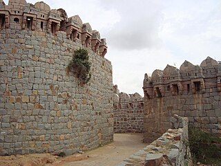
Kyadigera is a village in Devadurga taluk of Raichur district in the Indian state of Karnataka. Kyadigera was part of Shorapur kingdom and has an ancient fort. Kyadigera lies between Sirwar and Arakera.
Karatagi is a town and taluk headquarters of Karatagi taluk and it is located in Koppal District in Karnataka, India. It is one of the most important commercial centres in the district. The town is made up of multiple paddy fields, which are irrigated by the Tungabhadra Canal. Karatagi is known for its numerous rice mills, which can be found in the town and the surrounding areas.
Kotekal near Pamanakallur is a village in the Manvi taluk of Raichur district in the Indian state of Karnataka. Kotekal is located northwest to Manvi town. Kotekal lies on road connecting Raichur and Bagalkot. It is locally famous for its forts which were built 400 years ago. It is known in taluk for the village festival "durgamba jaatre" which will be celebrated once every 5 years.
Maladkal is a village in Karnataka state. It comes under Raichur District, Devadurga Taluk and Gabbur hobli. Maladkal lies in northern part of Karnataka. Maladkal shares its boundary with Gabbur, Ramadurga, Jagatakal, N Ganekal, Maseedpur and Atnur. Maladakal is one of the Gram Panchayat in Raichur District.
