Devil's Acre

Last updated

The Devil's Acre with the Palace of Westminster in the background, in an 1872 illustration by Gustave Dore. The illustration shows the Devil's Acre some years into the slum clearance, with the courtyard of small low-lying houses surrounded by multi-occupancy houses fronting onto Old Pye Street. Devils acre.jpg
The Devil's Acre with the Palace of Westminster in the background, in an 1872 illustration by Gustave Doré. The illustration shows the Devil's Acre some years into the slum clearance, with the courtyard of small low-lying houses surrounded by multi-occupancy houses fronting onto Old Pye Street.

The Devil's Acre was a notorious slum near Westminster Abbey in Victorian London. [2] The Devil's Acre was on and behind Old Pye Street, Great St Anne's Lane (now St Ann's Street) and Duck Lane (now St Matthew Street) in the parish of Westminster St Margaret and St John.

A slum is a highly populated urban residential area consisting mostly of closely packed, decrepit housing units in a situation of deteriorated or incomplete infrastructure, inhabited primarily by impoverished persons. While slums differ in size and other characteristics, most lack reliable sanitation services, supply of clean water, reliable electricity, law enforcement and other basic services. Slum residences vary from shanty houses to professionally built dwellings which, because of poor-quality construction or provision of basic maintenance, have deteriorated.

Westminster Abbey Church in London

Westminster Abbey, formally titled the Collegiate Church of Saint Peter at Westminster, is a large, mainly Gothic abbey church in the City of Westminster, London, England, just to the west of the Palace of Westminster. It is one of the United Kingdom's most notable religious buildings and the traditional place of coronation and burial site for English and, later, British monarchs. The building itself was a Benedictine monastic church until the monastery was dissolved in 1539. Between 1540 and 1556, the abbey had the status of a cathedral. Since 1560, the building is no longer an abbey or a cathedral, having instead the status of a Church of England "Royal Peculiar"—a church responsible directly to the sovereign.

Westminster St Margaret and St John

St Margaret was an ancient parish in the City and Liberty of Westminster and the county of Middlesex. It included the core of modern Westminster, including the Palace of Westminster and the area around, but not including Westminster Abbey. It was divided into St Margaret's and St John's in 1727, to coincide with the building of the Church of St John the Evangelist, constructed by the Commission for Building Fifty New Churches in Smith Square to meet the demands of the growing population, but there continued to be a single vestry for the parishes of St Margaret and St John. This was reformed in 1855 by the Metropolis Management Act, and the two parishes formed the Westminster District until 1887. St Margaret and St John became part of the County of London in 1889. The vestry was abolished in 1900, to be replaced by Westminster City Council, but St Margaret and St John continued to have a nominal existence until 1922.

Contents

In the 19th century it was considered one of the worst areas of London in 1850 Charles Dickens called it The Devil's Acre in Household Words . In the same year the term slum was popularised by Cardinal Wiseman, based at Westminster Cathedral adjoining the area, when his description of it was widely quoted in the national press.

Charles Dickens English writer and social critic

Charles John Huffam Dickens was an English writer and social critic. He created some of the world's best-known fictional characters and is regarded by many as the greatest novelist of the Victorian era. His works enjoyed unprecedented popularity during his lifetime, and by the 20th century critics and scholars had recognised him as a literary genius. His novels and short stories are still widely read today.

<i>Household Words</i> English weekly magazine edited by Charles Dickens in the 1850s

Household Words was an English weekly magazine edited by Charles Dickens in the 1850s. It took its name from the line in Shakespeare's Henry V: "Familiar in his mouth as household words."

Westminster Cathedral Church in London

Westminster Cathedral, or the Metropolitan Cathedral of the Precious Blood of Our Lord Jesus Christ, in London is the mother church of the Catholic Church in England and Wales.

Origins

Westminster has its origins in medieval times. The monks of the Westminster Abbey would offer safe haven to suspected criminals and debtors, leading to the area next to the western gate of the Abbey being called "the Sanctuary". This acquired a reputation for narrow streets and run-down dwellings, as did certain other parts of Westminster in the 18th century.

The area around Old Pye Street, Great St Anne's Lane (now St Ann's Street) and Duck Lane (now St Matthew Street), including most of the properties on those streets, was considered the worst. Prior to the 18th century the area was considered a desirable place to live, but in the middle of the 18th century gardens and courtyards were built over and the streets became "notoriously ill-paved and ill-maintained". Dwellings were built with the cheapest material, lacked ventilation, had poor lighting, and no drainage or sanitation facilities. [3] In particular, poorer parts of the City of London had a lack of night soil affordability which resulted, as in other major cities in the culverting (covering over) of all of its small streams, such as the Tyburn. This created stench in remnant low flood plains of their lowest course which is a particular feature of Westminster, Lambeth Marsh and the lowest areas of the docklands - all of this is visible from a simple contour map which often correlates with Booth's poverty map. [4]

City of London City and county in United Kingdom

The City of London is a city and county that contains the historic centre and the primary central business district (CBD) of London. It constituted most of London from its settlement by the Romans in the 1st century AD to the Middle Ages, but the agglomeration has since grown far beyond the City's borders. The City is now only a tiny part of the metropolis of London, though it remains a notable part of central London. Administratively, it forms one of the 33 local authority districts of Greater London; however, the City of London is not a London borough, a status reserved for the other 32 districts. It is also a separate county of England, being an enclave surrounded by Greater London. It is the smallest county in the United Kingdom.

Night soil Historically used euphemism for human excreta collected from cesspools, privies, pail closets, pit latrines etc.

Night soil is a historically used euphemism for human excreta collected from cesspools, privies, pail closets, pit latrines, privy middens, septic tanks, etc. This material was removed from the immediate area, usually at night, by workers employed in this trade. Sometimes it could be transported out of towns and sold on as a fertilizer.

Culvert Structure that allows the passage of water or organisms under an obstruction

A culvert is a structure that allows water to flow under a road, railroad, trail, or similar obstruction from one side to the other side. Typically embedded so as to be surrounded by soil, a culvert may be made from a pipe, reinforced concrete or other material. In the United Kingdom, the word can also be used for a longer artificially buried watercourse.

The area is low-lying, built along the relict of the forked river/stream the Tyburn. This made the area prone to waterlogging, and dwellings started to subside. By the 19th century the area was considered one of the worst in London and thought of as the centre of poverty, vice and crime. In 1850 Charles Dickens called the area The Devil's Acre in Household Words . [5] In the same year Cardinal Wiseman described the area as follows:

Close under the Abbey of Westminster there lie concealed labyrinths of lanes and courts, and alleys and slums, nests of ignorance, vice, depravity, and crime, as well as of squalor, wretchedness, and disease; whose atmosphere is typhus, whose ventilation is cholera; in which swarms of huge and almost countless population, nominally at least, Catholic; haunts of filth, which no sewage committee can reach – dark corners, which no lighting board can brighten. [3]

This passage, first published by Wiseman in An Appeal to the Reason and Good Feeling of the English People on the Subject of the Catholic Hierarchy, was widely quoted in the national press, [6] which led to the popularisation of the word slum to describe bad housing. [7] [8]

Inhabitants

Population density in the Devil's Acre was not measured in terms of persons per acre, but persons per room. [1] The area had a high rate of mortality from diseases such as typhoid and in 1848 Great Peter Street, Perkin's Rent, Duck Lane and Old Pye Street were the most densely populated streets in the district. The streets were mostly made up of old, irregular and run-down houses. Great Peter Street was mainly occupied by tradesmen, small shopkeepers, labourers, mechanics, and those with irregular or uncertain earnings. In Perkin's Rent, Duck Lane and Old Pye Street 10 to 12 people frequently lived in one room and the houses were mostly occupied by what a contemporary described as "mendicants, hawkers, costermongers, lodging house keepers, thieves and abandoned females of irregular and intemperate habits". [9]

Old Pye Street was lined with lodging houses and parts of Old Pye Street became known as "Irish rookery". An 1851 census of the common lodging houses on Old Pye Street, which was the centre of the Devil's Acre, describes the occupation of 20 lodgers in one house as: five "beggars", two "beggar bricklayers", one "labourer beggar", one "needlewoman beggar", one "hawker", one "labourer bricklayer" and one "errand boy". Initially the birthplace of 15 of the 20 was noted as unknown and they were later identified as Irish. [10]

Contemporary descriptions

In Ragged London, published in 1861, John Hollingshead described St Anne's Place in the Devil's Acre:

Enter a narrow street called St. Anne's Lane, glance up at a fearful side-court called St. Anne's Place, and wonder whether such filth and squalor can ever be exceeded. I went up the last-mentioned court, which had every feature of a sewer, and found a long puddle of sewage soaking in the hollow centre. The passages of the low black huts on either side were like old sooty chimneys, and the inhabitants were buried out of sight in the gloom. [11]

Hollingshead went on to describe Pye Street in the Devil's Acre:

I crossed over the road, and entered the openly acknowledged high street of thieves and prostitutes. It is called Pye Street, and has no mock modesty about it—no desire to conceal its real character. Threepenny "homes for travellers" abound on both sides-yellow, sickly, unwholesome places, many of them far below the level of the road, and entered by a kind of pit. Many of the houses have no flooring on their passages; and there is nothing for the barefooted children to stand upon but the black, damp, uneven earth. A child, dirty and nearly naked, was hanging out of one of the old-fashioned casement windows; and in the summer time it is no unusual thing to see about fifty coarse women exhibiting themselves in the same manner. The yards at the back of the houses contain little mountains of ashes and vegetable refuse; and a dust contractor's yard, in the centre of the street, seems to have burst its bounds, and to have nearly poured out its oyster-shells, cabbage-stalks, and broken china into the open thoroughfare. Shorthaired young men, with showy handkerchiefs round their neck, and tight corduroy trousers, were standing at most of the doors, looking pretty sharply about them from under the peaks of their caps. A fiddler was playing a dancing tune to a mixed assembly of thieves and prostitutes, and a morning ball was being arranged on both sides of the pavement. Many of the side streets and courts about here are shored up with black beams to keep the houses from falling, which adds to their wretched appearance. [11]

Churchman Frederic William Farrar also described Pye Street:

I think it would have been difficult to have found a spot more full of crime ... The whole street drank hard while such plunder lasted ... an instance of the low life under the shadows of the Abbey. I received a message one day to administer Holy Communion to a dying girl in Pye Street. She was in the last stages of consumption, and her story was to the effect that her husband lived on her wages, which he forced her to obtain by a life of sin  ... She summed up her repentance in one sentence: "I have worked very hard, and I am very tired." [12]

Slum clearance

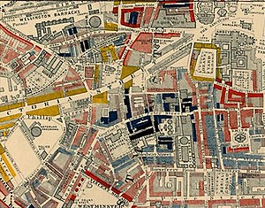
Part of Charles Booth's poverty map showing Westminster in 1889. The streets are coloured to represent the economic class of the residents: Yellow ("Upper-middle and Upper classes, Wealthy"), red ("Lower middle class - Well-to-do middle class"), pink ("Fairly comfortable good ordinary earnings"), blue ("Intermittent or casual earnings"), and black ("lowest class...occasional labourers, street sellers, loafers, criminals and semi-criminals"). Booth coloured Victoria Street, with its new shops and flats, yellow. The model dwellings built by the Peabody Trust on the sidestreets off Victoria Street were coloured pink and grey, signalling modest respectability, while the black and blue streets were the remaining slum areas housing the poorest. Booth map of Westminster.jpg
Part of Charles Booth's poverty map showing Westminster in 1889. The streets are coloured to represent the economic class of the residents: Yellow ("Upper-middle and Upper classes, Wealthy"), red ("Lower middle class – Well-to-do middle class"), pink ("Fairly comfortable good ordinary earnings"), blue ("Intermittent or casual earnings"), and black ("lowest class...occasional labourers, street sellers, loafers, criminals and semi-criminals"). Booth coloured Victoria Street, with its new shops and flats, yellow. The model dwellings built by the Peabody Trust on the sidestreets off Victoria Street were coloured pink and grey, signalling modest respectability, while the black and blue streets were the remaining slum areas housing the poorest.

As with a number of streets at the time, the building of Victoria Street was aimed at removing the slums in the area, and particularly the Devil's Acre. The street was formally opened in 1851 and, as with other such projects, it displaced rather than removed the slum. Along Victoria Street a mix of office blocks, shops and upper-class apartment buildings, also known as French Flats, were built. [13]

The street had been planned as an experiment in sanitary and moral engineering. In deciding the route of the street, the planner James Pennethorne's objective "has only been to ascertain how best to improve the condition of the inhabitants of Westminster by improving the buildings, the levels, and the sewers, and by opening communications through the most crowded parts." The street was several feet above the low-lying, badly drained marshland between Westminster and the western part: what became Belgravia. In medieval times it was known as Thorney Island and thus some of its edges were not drained being in the Tyburn marsh itself. In 1850 considerable parts of Westminster were under the high-water mark of the Thames, and Victoria Street was designed to drain the area and clear the slums. Such developments were termed "town swamps and social bridges" by George Godwin. Pennethorne designed the street with a slight angle so that it would route through the Devil's Acre. The slum inhabitants were displaced by the Victoria Street developments, as the quantity of low-rent houses in the area declined and they were unable to afford the rents of the newly constructed flats. John Hollingshead reported at the time that Victoria Street had divided "the diseased heart" in half, pushing inhabitants into the surrounding areas. The Bishop of London informed the House of Lords that Victoria Street had displaced 5,000 people, 75 per cent of whom moved into already overcrowded areas south of the Thames, with the remaining people staying in declining low-rent accommodation in Westminster. New blocks of flats were constructed along Victoria Street and, according to Hollingshead, "While the nighmare street of unlet places was waiting for more capital to fill its yawning gulf, and a few more residents to warm its hollow chambers into life, the landlords of the slums were raising their rents: and thieves, prostitutes, labourers, and working women were packing in a smaller compas." [14]

From the 1850s onwards the area around Westminster, including the Devil's Acre, became the focus of a new movement of social housing, largely funded by George Peabody and the Peabody Trust. This movement had a lasting impact on the urban character of Westminster and many of the philanthropically funded social housing estates have survived into the 21st century. [15]

Slum clearance began with the Rochester Buildings, on the corner of Old Pye Street and Perkin's Rent, which were built in 1862 by the merchant William Gibbs. They are one of the earliest large-scale philanthropic housing developments in London. The Rochester Buildings were sold to the Peabody Trust in 1877 and later become known as Blocks A to D of the Old Perkin's Rents Estate. Angela Burdett-Coutts, 1st Baroness Burdett-Coutts funded an experimental social housing estate, among the first of its kind, on the corner of Columbia Road and Old Pye Street (now demolished). [15] In 1869 the Peabody Trust built one of its first housing estates at Brewer's Green, between Victoria Street and St. James's Park. What remained of the Devil's Acre on the other side of Victoria Street was cleared and further Peabody estates were built after the Cross Act of 1875. [13]

The Abbey Orchard Estate, Old Pye Street. Abbey Orchard Estate Old Pye Street.JPG
The Abbey Orchard Estate, Old Pye Street.

In 1882, the Peabody Trust built the Abbey Orchard Estate on the corner of Old Pye Street and Abbey Orchard Street. The estate was designed by Henry Darbishire and built on former marshland. The buildings rest on arches, supported by a foundation of piles. Like many of the social housing estates, the Abbey Orchard Estate was built following the square plan concept. Blocks of flats were built around a courtyard, creating a semi-private space within the estate functioning as recreation area. The courtyards were meant to create a community atmosphere and the blocks of flats were designed to allow sunlight into the courtyards. The blocks of flats were built using high-quality brickwork and included architectural features such as lettering, glazing, fixtures and fittings. The estates built in the area at the time were considered model dwellings and included shared laundry and sanitary facilities, innovative at the time, and fireplaces in some bedrooms. The design was subsequently repeated in numerous other housing estates in London. [15]

See also

Related Research Articles

Battersea area of the London Borough of Wandsworth, England

Battersea is a district of south west London, England, within the London Borough of Wandsworth. It is located on the south bank of the River Thames, 2.9 miles (4.7 km) south west of Charing Cross.

Mayfair area of central London, England

Mayfair is an affluent area in the West End of London towards the eastern edge of Hyde Park, in the City of Westminster, between Oxford Street, Regent Street, Piccadilly and Park Lane. It is one of the most expensive districts in London and the world.

Morden district in the London Borough of Merton, England

Morden is a district and town in the London Borough of Merton, England, located around 8 miles (13 km) south-southwest of central London. Historically part of Surrey, it was absorbed into Greater London in 1965. Morden adjoins Merton Park and Wimbledon to the north, Mitcham to the east, Sutton to the south and Worcester Park to the west.

Thamesmead district of south-east London, England

Thamesmead is a district in the Royal Borough of Greenwich and Bexley. It is located 11 miles (18 km) east of Charing Cross, mainly consisting of social housing built from the mid-1960s onwards on former marshland on the south bank of the River Thames, northeast of Woolwich and west of Belvedere.

Covent Garden district in London, England

Covent Garden is a district in Greater London, on the eastern fringes of the West End, between Charing Cross Road and Drury Lane. It is associated with the former fruit-and-vegetable market in the central square, now a popular shopping and tourist site, and with the Royal Opera House, which is also known as "Covent Garden". The district is divided by the main thoroughfare of Long Acre, north of which is given over to independent shops centred on Neal's Yard and Seven Dials, while the south contains the central square with its street performers and most of the historical buildings, theatres and entertainment facilities, including the London Transport Museum and the Theatre Royal, Drury Lane.

Millbank area and road in City of Westminster

Millbank is an area of central London in the City of Westminster. Millbank is located by the River Thames, east of Pimlico and south of Westminster. Millbank is known as the location of major government offices, Burberry headquarters, the Millbank Tower and prominent art institutions such as Tate Britain and the Chelsea College of Art and Design.

Urban renewal Land redevelopment in cities

Urban renewal is a program of land redevelopment in cities, often where there is urban decay. Urban renewal often refers to the clearing out of blighted areas in inner cities to clear out slums and create opportunities for higher class housing, businesses, and more. Modern attempts at renewal began in the late 19th century in developed nations, and experienced an intense phase in the late 1940s under the rubric of reconstruction. The process has had a major impact on many urban landscapes, and has played an important role in the history and demographics of cities around the world.

Kings Island, Limerick

King's Island is an area of central Limerick, Ireland. The area is often referred to colloquially as The Island and consists of two distinct areas, Englishtown and St Mary's Park. The historical city of Limerick known as Englishtown is located on the southern end and St Mary's Park; a local authority housing estate is located on the northern end.

St Helier, London residential estate in the London boroughs of Merton and Sutton

St Helier is a residential cottage estate in the London boroughs of Merton and Sutton. The portion of the estate north of Green Lane and Bishopsford Road is in Merton, the remainder is in Sutton.

Lordship Lane connects Wood Green (N22) with Tottenham High Road (N17). It lies in the London Borough of Haringey and forms part of the A109 road.

Victoria, London district within central London

Victoria is a small district in the City of Westminster in central London, named after the major transport hub which covers large part of the district, Victoria Station, which is named after the nearby Victoria Street, in turn named after Queen Victoria.

Lisson Grove road

Lisson Grove is a district and a street of the City of Westminster, London, just to the north of the city ring road. There are many landmarks surrounding the area. To the north is Lord's Cricket Ground in St John's Wood. To the west are Little Venice, Paddington and Watling Street. To the north east is Primrose Hill and south east is Marylebone, which includes the railway station and Dorset Square, the original home of the Marylebone Cricket Club. It is west of the London Planetarium, Madame Tussaud's, Baker Street and Regent's Park. The postal districts are NW1 and NW8.

Boundary Estate housing in London, Britain

The Boundary Estate is a housing development in Shoreditch, formally opened in 1900, in the East End of London, England. It is situated in the London Borough of Tower Hamlets and on the boundary with Bethnal Green.

Housing Commission of Victoria

The Housing Commission of Victoria was a Victorian State Government body responsible for public housing in Victoria, Australia. It was established in 1938, and was abolished in 1984.

Old Nichol

The Old Nichol, also known as the Nichol or the Old Nichol Street Rookery, was an area of housing in the East End of London, between Shoreditch High Street and Hackney Road in the north, and Spitalfields in the south. The main streets within the Old Nichol were Boundary Street, Old Nichol Street, Half Nichol Street, The Mount and Church Street. The slum straddled the western boundary of Bethnal Green, with six of its streets across Boundary Street located in Shoreditch. The Old Nichol was home to 5,719 people, living in a dense network of about 30 streets and courts. The late 18th-century houses included workshops and stables.

The Improved Industrial Dwellings Company (IIDC) was a Victorian Model dwellings company founded in 1863 by the printer, philanthropist and later Lord Mayor of London Sir Sydney Waterlow. The company operated predominantly in Central London as a provider of block dwellings for the working classes, employing a strict selection and discipline regime amongst its tenants to ensure a healthy return on investment. Starting with a capital of £50,000, the IIDC became one of the largest and most successful of the model dwellings companies, housing at its height around 30,000 individuals.

Public housing in the United Kingdom

Public housing in the United Kingdom provided the majority of rented accommodation in the country until 2011. Houses built for public or social housing use are built by or for local authorities and known as council houses. Before 1865, housing for the poor was provided solely by the private sector. Council houses were built on council estates, where other amenities, like schools and shops, were often also provided. From the 1950s, blocks of flats and three- or four-storey blocks of maisonettes were widely built. Flats and houses were also built in mixed estates.

Portland Road, Notting Hill

Portland Road is a road in Notting Hill, in the Royal Borough of Kensington and Chelsea that was built as a speculative development in the 1850s. The road has been noted for its division into three sections of different wealth: the section between Holland Park Avenue and Clarendon Cross/Hippodrome Place being one of the most expensive places to buy a house in London, a section of terraced houses further north being also very expensive but less so than the lower reaches of the road, and a section at the northern end that was once slums and is now working class social housing and is described as being north of an "invisible line" that divides it from the privately owned sections of the road.

References

  1. 1 2 Richard, Dennis (2008). Cities in modernity: representations and productions of metropolitan space. Cambridge University Press. p. 139. ISBN   978-0-521-46841-1.
  2. Quinn, Tom (2000). London's Strangest Tales: Extraordinary But Trues Stories. Anova Books. p. 154. ISBN   978-1-86105-976-5.
  3. 1 2 Ward, Wilfrid Philip (2008). The Life and Times of Cardinal Wiseman, Volume 1. BiblioBazaar. p. 568. ISBN   978-0-559-68852-2.
  4. OS Map of the City of Westminster with contours shown Archived 24 April 2012 at the Wayback Machine .
  5. "The clay tobacco pipe industry in the parish of St Margaret and St John the Evangelist, Westminster". London Clay Pipe Studies.
  6. Dyos, H.J.; Cannadine, David; Reeder, David (1982). Exploring the urban past: essays in urban history. Cambridge University Press. p. 240. ISBN   978-0-521-28848-4.
  7. Wohl, Anthony S. (2002). The eternal slum: housing and social policy in Victorian London. Transaction Publishers. p. 5. ISBN   978-0-7658-0870-7.
  8. Dyos, H.J.; Cannadine, David; Reeder, David (1982). 131 Exploring the urban past: essays in urban history. Cambridge University Press. ISBN   978-0-521-28848-4.
  9. Edwin, Chadwick (1848 (republished 2009)). Report on the Sanitary Conditions of the Labouring Population of Great Britain. General Books LLC. p. 255. ISBN   978-1-150-08887-2.Check date values in: |date= (help)
  10. 1 2 Richard, Dennis (2008). Cities in modernity: representations and productions of metropolitan space. Cambridge University Press. p. 140. ISBN   978-0-521-46841-1.
  11. 1 2 Hollingshead, John (1861). Ragged London – The West. Victorian London.
  12. Farrar, Reginald (2008). The Life of Frederic William Farrar. BiblioBazaar. p. 236. ISBN   978-0-559-72501-2.
  13. 1 2 Palliser, David Michael; Clark, Peter; Daunton, Martin J. (2000). The Cambridge Urban History of Britain: 1840–1950. Cambridge University Press. p. 112. ISBN   978-0-521-41707-5.
  14. Richard, Dennis (2008). Cities in modernity: representations and productions of metropolitan space. Cambridge University Press. p. 138. ISBN   978-0-521-46841-1.
  15. 1 2 3 "Proposed Designation of Peabody Estates: South Westminster Conservation Area" (PDF). City of Westminster, Planning & City Development. 2006.

Coordinates: 51°29′49″N0°07′55″W / 51.497°N 0.132°W / 51.497; -0.132