
Contra Costa County is a county located in the U.S. state of California, in the East Bay of the San Francisco Bay Area. As of the 2020 United States Census, the population was 1,165,927. The county seat is Martinez. It occupies the northern portion of the East Bay region of the San Francisco Bay Area and is primarily suburban. The county's name refers to its position on the other side of the bay from San Francisco. Contra Costa County is included in the San Francisco–Oakland–Berkeley, CA Metropolitan Statistical Area.
Alamo is an unincorporated community and census-designated place (CDP) in Contra Costa County, California, in the United States. It is a suburb located in the San Francisco Bay Area's East Bay region, approximately 28 miles (45 km) east of San Francisco. Alamo is equidistant from the city of Walnut Creek and the incorporated town of Danville. As of the 2020 census, the population was 15,314.

Concord is the most populous city in Contra Costa County, California, United States. According to an estimate completed by the United States Census Bureau, the city had a population of 129,295 in 2019, making it the eighth most populous city in the San Francisco Bay Area. Founded in 1869 as Todos Santos by Don Salvio Pacheco II, a noted Californio ranchero, the name was later changed to Concord. The city is a major regional suburban East Bay center within the San Francisco Bay Area, and is 29 miles east of San Francisco.
The Town of Danville is located in the San Ramon Valley in Contra Costa County, California, United States. It is one of the incorporated municipalities in California that use "town" in their names instead of "city". The population was 43,582 at the 2020 census. Since 2018, for five consecutive years, Danville was named "the safest town in California".

Walnut Creek is a city in Contra Costa County, California, United States, located in the East Bay region of the San Francisco Bay Area, about 16 miles east of the city of Oakland. Walnut Creek has a total population of 70,127 per the 2020 census, is located at the junction of the highways from Sacramento and San Jose (I-680) and San Francisco/Oakland (SR-24), and is accessible by BART. The city shares its borders with Clayton, Lafayette, Alamo, Pleasant Hill, and Concord.

Mount Diablo is a mountain of the Diablo Range, in Contra Costa County of the eastern San Francisco Bay Area in Northern California. It is south of Clayton and northeast of Danville. It is an isolated upthrust peak of 3,849 feet, visible from most of the San Francisco Bay Area. Mount Diablo appears from many angles to be a double pyramid and has many subsidiary peaks. The largest and closest is North Peak, the other half of the double pyramid, which is nearly as high in elevation at 3,557 feet (1,084 m), and is about one mile northeast of the main summit.

The Tri-Valley area is grouping of three valleys in the East Bay region of California's Bay Area. The three valleys are Amador Valley, San Ramon Valley, and Livermore Valley. The Tri-Valley encompasses the cities of Dublin, Livermore, Pleasanton and San Ramon, the town of Danville and the CDPs of Alamo, Blackhawk and Diablo. The area is known for its Mediterranean climate, wineries, and nature. It is primarily suburban in character. The United States Census Bureau defines an urban area centered in the cities of Livermore, Pleasanton, and Dublin with a 2020 population of 240,381, ranked 167th in the United States in terms of population. The total population of the area is estimated to be 361,000. It offers more affordable living accommodations than the cities of San Francisco and San Jose.
Diablo Valley College (DVC) is a public community college with campuses in Pleasant Hill and San Ramon in Contra Costa County, California. DVC is one of three public community colleges in the Contra Costa Community College District. It opened in 1949. DVC has more than 22,000 students and 300 full-time and 370 part-time instructors.

The East Bay is the eastern region of the San Francisco Bay Area and includes cities along the eastern shores of the San Francisco Bay and San Pablo Bay. The region has grown to include inland communities in Alameda and Contra Costa counties. With a population of roughly 2.8 million in 2024, it is the most populous subregion in the Bay Area, containing the second- and third-most populous Bay Area counties of Alameda and Contra Costa.

The Diablo Range is a mountain range in the California Coast Ranges subdivision of the Pacific Coast Ranges in northern California, United States. It stretches from the eastern San Francisco Bay Area at its northern end to the Salinas Valley area at its southern end.
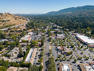
The San Ramon Valley is a valley and region in Contra Costa County and Alameda County, in the East Bay region of the San Francisco Bay Area in northern California.

The Coast Ranges of California span 400 miles (644 km) from Del Norte or Humboldt County, California, south to Santa Barbara County. The other three coastal California mountain ranges are the Transverse Ranges, Peninsular Ranges and the Klamath Mountains.
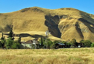
Morgan Territory is an historic ranching area on the east side of Mount Diablo in San Francisco East Bay's Contra Costa County. It was named after Anglo-American pioneer Jeremiah Morgan, a migrant from Alabama and Iowa who acquired 2000 acres and developed a ranch here, starting in 1857.
The Black Diamond Mines Regional Preserve is a 6,000-acre (2,400 ha) park located north of Mount Diablo in Contra Costa County, California under the administration of the East Bay Regional Park District (EBRPD). The district acquired the property in 1973. The preserve contains relics of 3 mining towns, former coal and sand mines, and offers guided tours of a former sand mine. The 60 miles (97 km) of trails in the Preserve cross rolling foothill terrain covered with grassland, California oak woodland, California mixed evergreen forest, and chaparral.
Morgan Territory Regional Preserve is a regional park in Contra Costa County, California. Located east of Clayton and north of Livermore, California, bordering on Mt. Diablo State Park, it is part of the East Bay Regional Park District (EBRPD). The preserve was founded in 1975 with fewer than 1,000 acres (400 ha), but EBRPD has gradually acquired more property, and, since 2015, the preserve encompasses 5,230 acres (2,120 ha). The main access roads run from Livermore and Clayton.

The Livermore Valley, historically known as the Valle de San José, is a valley in Alameda County, California, located in the East Bay region. The city of Livermore is located in the valley. The valley became known as "Livermore's Valley", and today as the "Livermore Valley" after Robert Livermore, an early settler and rancher in the region who received together with José Noriega a land grant composing most of modern Livermore.

Pleasanton Ridge Regional Park is a 5,271-acre (21.33 km2) park in the East Bay Regional Park District overlooking Pleasanton, California and the Livermore Valley to the east.
KVHS is a non-profit high school radio station playing an active rock music format. It is licensed to the Mt. Diablo Unified School District and broadcasts from the campus of Clayton Valley Charter High School, Concord, California. The signal reaches the counties of Contra Costa, Solano, Napa, San Joaquin, West Sacramento and Yolo, and KVHS primarily serves the Diablo Valley area.
The defunct Boy Scout councils are those which have been closed and merged with other councils.
