Related Research Articles

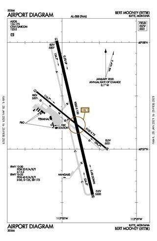
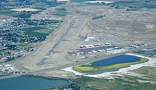
Bert Mooney Airport is a public airport three miles southeast of Butte, in Silver Bow County, Montana, United States. It is owned by the Bert Mooney Airport Authority.

Yellowstone Regional Airport is a public-use airport located two nautical miles (3.7 km) southeast of the central business district of Cody, a city in Park County, Wyoming, United States. It is the only commercial airport in Park County Wyoming. It is in northwestern Wyoming, about 53 miles from the east entrance of Yellowstone National Park.

Helena Regional Airport is a public airport two miles northeast of Helena, in Lewis and Clark County, Montana, United States. It is owned by the Helena Regional Airport Authority.

Missoula Montana Airport is located in Missoula, in Missoula County, Montana. It is owned by the Missoula County Airport Authority.
Pittsfield Municipal Airport is two miles west of Pittsfield, in Berkshire County, Massachusetts. The National Plan of Integrated Airport Systems for 2011–2015 categorized it as a general aviation facility.
Baker City Municipal Airport is three miles north of Baker City, in Baker County, Oregon, United States. The National Plan of Integrated Airport Systems for 2011–2015 categorized it as a general aviation facility.

Grant County Regional Airport - GCRA is in Grant County, Oregon, a mile southwest of John Day, Oregon. The National Plan of Integrated Airport Systems for 2011–2015 categorized it as a general aviation facility.
Delaware County Regional Airport is in Delaware County, Indiana three miles northwest of Muncie. Owned by the Delaware County Airport Authority, it was formerly Delaware County Airport and Johnson Field. The National Plan of Integrated Airport Systems for 2011–2015 categorized it as a general aviation facility.
Keokuk Municipal Airport is five miles northwest of Keokuk, in Lee County, Iowa. The National Plan of Integrated Airport Systems for 2017–2021 categorized it as a general aviation facility.

Marion County Regional Airport is a county-owned public-use airport in Marion County, Arkansas, United States. It is located one nautical mile north of the central business district of Flippin, Arkansas.

Eagle River Union Airport is a city owned public use airport located in Eagle River, a city in Vilas County, Wisconsin, United States. It is included in the Federal Aviation Administration (FAA) National Plan of Integrated Airport Systems for 2021–2025, in which it is categorized as a local general aviation facility.

Cut Bank Municipal Airport is three miles southwest of Cut Bank, in Glacier County, Montana, United States. It is owned by Cut Bank and Glacier County.

Austin Municipal Airport is a public owned public use airport located two nautical miles (3.2 km) east of the central business district of the city of Austin, in Mower County, Minnesota, United States.
Perry Municipal Airport is a city-owned public-use airport located three nautical miles west of the central business district of Perry, a city in Dallas County, Iowa, United States. This airport is included in the FAA's National Plan of Integrated Airport Systems for 2015–2019, which categorized it as a general aviation facility.
Marion Municipal Airport is located three miles southwest of Marion, in Grant County, Indiana. The FAA's National Plan of Integrated Airport Systems for 2021–2025 categorized it as a general aviation facility.

Dexter B. Florence Memorial Field is a city-owned public-use airport located one nautical mile south of the central business district of Arkadelphia, a city in Clark County, Arkansas, United States.
Mission Field is a public use airport located five nautical miles east of the central business district of Livingston, a city in Park County, Montana, United States. It is owned by the city and county. This airport is included in the National Plan of Integrated Airport Systems for 2011–2015, which categorized it as a general aviation facility.
Sher-Wood Airport is a public use airport located one nautical mile (2 km) northeast of the central business district of Plentywood, a city in Sheridan County, Montana, United States. It is owned by the city and county. This airport is included in the National Plan of Integrated Airport Systems for 2011–2015, which categorized it as a general aviation facility.
Shelby Airport is a county-owned airport two miles north of Shelby, in Toole County, Montana. The National Plan of Integrated Airport Systems for 2011–2015 called it a general aviation airport.
Polson Airport is a public use airport in Lake County, Montana, United States. It is located one nautical mile (2 km) west of the central business district of Polson, a city on the southern shore of Flathead Lake. The airport is owned by the City of Polson and Lake County. It is included in the National Plan of Integrated Airport Systems for 2011–2015, which categorized it as a general aviation facility.
References
- 1 2 3 4 FAA Airport Form 5010 for DLN PDF , effective 2023-08-10.
- ↑ Accident descriptionfor N22HP at the Aviation Safety Network . Retrieved on August 22, 2023.