Dintikon

Last updated
Dintikon
Dintikon 1515.jpg
CHE Dintikon COA.svg
Location of Dintikon
Dintikon
Switzerland adm location map.svg
Red pog.svg
Dintikon
Reliefkarte Aargau blank.png
Red pog.svg
Dintikon
Coordinates: 47°22′N8°14′E / 47.367°N 8.233°E / 47.367; 8.233
Country Switzerland
Canton Aargau
District Lenzburg
Area
[1]
  Total3.73 km2 (1.44 sq mi)
Elevation
449 m (1,473 ft)
Population
 (31 December 2018) [2]
  Total2,228
  Density600/km2 (1,500/sq mi)
Time zone UTC+01:00 (Central European Time)
  Summer (DST) UTC+02:00 (Central European Summer Time)
Postal code(s)
5606
SFOS number 4194
Surrounded by Ammerswil, Egliswil, Hendschiken, Seengen, Villmergen
Website www.dintikon.ch
SFSO statistics

Dintikon is a municipality in the district of Lenzburg in the canton of Aargau in Switzerland.

Contents

The small village is located near Lenzburg and Wohlen.

Aerial view (1964) ETH-BIB-Dintikon-LBS H1-024305.tif
Aerial view (1964)

History

Dintikon is first mentioned in 924 as Tintinchowa. [3]

Geography

Frozen forest pond at the south side of the road from Ammerswil to Dintikon Dintikon glaciighinta arbarlageto 300.jpg
Frozen forest pond at the south side of the road from Ammerswil to Dintikon

Dintikon has an area, as of 2009, of 3.73 square kilometers (1.44 sq mi). Of this area, 1.45 km2 (0.56 sq mi) or 38.9% is used for agricultural purposes, while 1.57 km2 (0.61 sq mi) or 42.1% is forested. Of the rest of the land, 0.7 km2 (0.27 sq mi) or 18.8% is settled (buildings or roads). [4]

Of the built up area, industrial buildings made up 4.0% of the total area while housing and buildings made up 9.9% and transportation infrastructure made up 4.0%. Out of the forested land, all of the forested land area is covered with heavy forests. Of the agricultural land, 18.0% is used for growing crops and 19.3% is pastures, while 1.6% is used for orchards or vine crops. [4]

The municipality is located in the Lenzburg district, from the eastern edge of the Rietenberg to the edge of the Bünztal (Bünz valley).
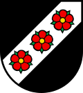
Coat of arms

The blazon of the municipal coat of arms is Sable on a Bend sinister three Roses Gules barbed and seeded proper. [5]

Demographics

Dintikon has a population (as of December 2020) of 2,317. [6] As of June 2009, 19.0% of the population are foreign nationals. [7] Over the last 10 years (1997–2007) the population has changed at a rate of 28.9%. Most of the population (as of 2000) speaks German (93.0%), with Italian being second most common ( 2.8%) and Albanian being third ( 0.9%). [8]

The age distribution, as of 2008, in Dintikon is; 217 children or 12.1% of the population are between 0 and 9 years old and 227 teenagers or 12.7% are between 10 and 19. Of the adult population, 234 people or 13.0% of the population are between 20 and 29 years old. 247 people or 13.8% are between 30 and 39, 326 people or 18.2% are between 40 and 49, and 254 people or 14.2% are between 50 and 59. The senior population distribution is 167 people or 9.3% of the population are between 60 and 69 years old, 78 people or 4.3% are between 70 and 79, there are 38 people or 2.1% who are between 80 and 89, and there are 6 people or 0.3% who are 90 and older. [9]

As of 2000 the average number of residents per living room was 0.56 which is about equal to the cantonal average of 0.57 per room. In this case, a room is defined as space of a housing unit of at least 4 m2 (43 sq ft) as normal bedrooms, dining rooms, living rooms, kitchens and habitable cellars and attics. [10] About 66.7% of the total households were owner occupied, or in other words did not pay rent (though they may have a mortgage or a rent-to-own agreement). [11]

As of 2000, there were 33 homes with 1 or 2 persons in the household, 197 homes with 3 or 4 persons in the household, and 250 homes with 5 or more persons in the household. [12] As of 2000, there were 506 private households (homes and apartments) in the municipality, and an average of 2.6 persons per household. [8] In 2008 there were 306 single family homes (or 42.9% of the total) out of a total of 714 homes and apartments. [13] There were a total of 5 empty apartments for a 0.7% vacancy rate. [13] As of 2007, the construction rate of new housing units was 64.5 new units per 1000 residents. [8]

In the 2007 federal election the most popular party was the SVP which received 44.5% of the vote. The next three most popular parties were the FDP (19.3%), the SP (11.8%) and the CVP (8.6%). [8]

Dintikon school Dintikon lernejo 309.jpg
Dintikon school

The entire Swiss population is generally well educated. In Dintikon about 75.1% of the population (between age 25-64) have completed either non-mandatory upper secondary education or additional higher education (either university or a Fachhochschule ). [8] Of the school age population (in the 2008/2009 school year), there are 163 students attending primary school in the municipality. [12]

The historical population is given in the following table: [3]

Historical population
YearPop.±%
1850 673    
1900 524−22.1%
1950 783+49.4%
2000 1,307+66.9%

Economy

As of  2007, Dintikon had an unemployment rate of 2%. As of 2005, there were 44 people employed in the primary economic sector and about 12 businesses involved in this sector. 206 people are employed in the secondary sector and there are 25 businesses in this sector. 897 people are employed in the tertiary sector, with 53 businesses in this sector. [8]

In 2000 there were 724 workers who lived in the municipality. Of these, 548 or about 75.7% of the residents worked outside Dintikon while 900 people commuted into the municipality for work. There were a total of 1,076 jobs (of at least 6 hours per week) in the municipality. [14] Of the working population, 9.3% used public transportation to get to work, and 59.8% used a private car. [8]

Religion

From the 2000 census, 485 or 37.1% were Roman Catholic, while 630 or 48.2% belonged to the Swiss Reformed Church. [12]

Related Research Articles

<span class="mw-page-title-main">Beinwil am See</span> Municipality in Aargau, Switzerland

Beinwil am See is a municipality in the district of Kulm in the canton of Aargau in Switzerland.

<span class="mw-page-title-main">Lenzburg</span> Municipality in Aargau, Switzerland

Lenzburg is a town in the central region of the Swiss canton of Aargau and is the capital of the Lenzburg District. The town, founded in the Middle Ages, lies in the Seetal valley, about 3 kilometres south of the Aare river. Lenzburg and the neighbouring municipalities of Niederlenz and Staufen have grown together in an agglomeration.

<span class="mw-page-title-main">Fahrwangen</span> Municipality in Aargau, Switzerland

Fahrwangen is a municipality in the district of Lenzburg in the canton of Aargau in Switzerland.

<span class="mw-page-title-main">Seon, Aargau</span> Municipality in Aargau, Switzerland

Seon is a municipality in the district of Lenzburg in the canton of Aargau in Switzerland.

<span class="mw-page-title-main">Kirchleerau</span> Municipality in Aargau, Switzerland

Kirchleerau is a municipality in the district of Zofingen in the canton of Aargau in Switzerland.

<span class="mw-page-title-main">Reitnau</span> Municipality in Aargau, Switzerland

Reitnau is a municipality in the district of Zofingen in the canton of Aargau in Switzerland. On 1 January 2019 the former municipality of Attelwil merged into the municipality of Reitnau.

<span class="mw-page-title-main">Eggenwil</span> Municipality in Aargau, Switzerland

Eggenwil is a municipality in the district of Bremgarten in the canton of Aargau in Switzerland.

<span class="mw-page-title-main">Hägglingen</span> Municipality in Aargau, Switzerland

Hägglingen is a municipality in the district of Bremgarten in the canton of Aargau in Switzerland.

<span class="mw-page-title-main">Ammerswil</span> Municipality in Aargau, Switzerland

Ammerswil is a municipality in the district of Lenzburg in the canton of Aargau in Switzerland. It is located 3 km (2 mi) southeast of the town of Lenzburg.

<span class="mw-page-title-main">Burg, Aargau</span> Former municipality in Aargau, Switzerland

Burg is a former municipality in the district of Kulm in the canton of Aargau in Switzerland. On 1 January 2023 the former municipality of Burg merged to form the municipality of Menziken.

<span class="mw-page-title-main">Dürrenäsch</span> Municipality in Aargau, Switzerland

Dürrenäsch is a municipality in the district of Kulm in the canton of Aargau in Switzerland.

<span class="mw-page-title-main">Boniswil</span> Municipality in Aargau, Switzerland

Boniswil is a municipality in the district of Lenzburg in the canton of Aargau in Switzerland.

<span class="mw-page-title-main">Brunegg</span> Municipality in Aargau, Switzerland

Brunegg is a municipality in the district of Lenzburg in the canton of Aargau in Switzerland.

<span class="mw-page-title-main">Egliswil</span> Municipality in Aargau, Switzerland

Egliswil is a municipality and village in the district of Lenzburg in the canton of Aargau in Switzerland.

<span class="mw-page-title-main">Hallwil</span> Municipality in Aargau, Switzerland

Hallwil is a municipality in the district of Lenzburg in the canton of Aargau in Switzerland.

<span class="mw-page-title-main">Hendschiken</span> Municipality in Aargau, Switzerland

Hendschiken is a municipality in the district of Lenzburg in the canton of Aargau in Switzerland.

<span class="mw-page-title-main">Hunzenschwil</span> Municipality in Aargau, Switzerland

Hunzenschwil is a municipality in the district of Lenzburg in the canton of Aargau in Switzerland.

<span class="mw-page-title-main">Schafisheim</span> Municipality in Aargau, Switzerland

Schafisheim is a municipality in the district of Lenzburg in the canton of Aargau in Switzerland.

<span class="mw-page-title-main">Seengen</span> Municipality in Aargau, Switzerland

Seengen is a municipality in the district of Lenzburg in the canton of Aargau in Switzerland.

<span class="mw-page-title-main">Staufen, Aargau</span> Municipality in Aargau, Switzerland

Staufen is a municipality in the district of Lenzburg in the canton of Aargau in Switzerland.

References

  1. "Arealstatistik Standard - Gemeinden nach 4 Hauptbereichen". Federal Statistical Office. Retrieved 13 January 2019.
  2. "Ständige Wohnbevölkerung nach Staatsangehörigkeitskategorie Geschlecht und Gemeinde; Provisorische Jahresergebnisse; 2018". Federal Statistical Office. 9 April 2019. Retrieved 11 April 2019.
  3. 1 2 Dintikon in German , French and Italian in the online Historical Dictionary of Switzerland .
  4. 1 2 Swiss Federal Statistical Office-Land Use Statistics 2009 data (in German) accessed 25 March 2010
  5. Flags of the World.com Archived 2012-10-04 at the Wayback Machine accessed 13-May-2010
  6. "Ständige und nichtständige Wohnbevölkerung nach institutionellen Gliederungen, Geburtsort und Staatsangehörigkeit". bfs.admin.ch (in German). Swiss Federal Statistical Office - STAT-TAB. 31 December 2020. Retrieved 21 September 2021.
  7. Statistical Department of Canton Aargau -Bereich 01 -Bevölkerung Archived 2012-02-22 at the Wayback Machine (in German) accessed 20 January 2010
  8. 1 2 3 4 5 6 7 Swiss Federal Statistical Office Archived January 5, 2016, at the Wayback Machine accessed 13-May-2010
  9. Statistical Department of Canton Aargau -Bevölkerungsdaten für den Kanton Aargau und die Gemeinden (Archiv) Archived 2012-02-22 at the Wayback Machine (in German) accessed 20 January 2010
  10. Eurostat. "Housing (SA1)". Urban Audit Glossary (PDF). 2007. p. 18. Archived from the original (PDF) on 14 November 2009. Retrieved 12 February 2010.
  11. Urban Audit Glossary pg 17
  12. 1 2 3 Statistical Department of Canton Aargau - Aargauer Zahlen 2009 Archived 2012-02-22 at the Wayback Machine (in German) accessed 20 January 2010
  13. 1 2 Statistical Department of Canton Aargau Archived 2012-02-22 at the Wayback Machine (in German) accessed 20 January 2010
  14. Statistical Department of Canton Aargau-Bereich 11 Verkehr und Nachrichtenwesen Archived 2012-02-22 at the Wayback Machine (in German) accessed 21 January 2010