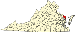
Dodlyt is an unincorporated community in Northumberland County, in the U.S. state of Virginia.
Violet is a census-designated place (CDP) in St. Bernard Parish, Louisiana, United States. The population was 5,758 at the 2020 census. Violet is located on the east bank of the Mississippi River, approximately 7.5 miles (12.1 km) southeast of New Orleans and is part of the New Orleans–Metairie–Kenner metropolitan statistical area.
Womelsdorf (Coalton) is a town in Randolph County, West Virginia, United States. The population was 190 at the 2020 census.
Mineralwells, also known as Mineral Wells, is a census-designated place (CDP) in Wood County, West Virginia, United States. It is part of the Parkersburg-Marietta-Vienna, WV-OH Metropolitan Statistical Area. The population was 1,950 at the 2010 census. The population was 2216 at the 2021 census.
Cape Fair is an unincorporated community in Stone County, Missouri, United States. It is located on Route 76 and the southern terminus of Route 173. Cape Fair is on the west side of the James River arm of Table Rock Lake. The community is part of the Branson, Missouri Micropolitan Statistical Area. The ZIP Code for Cape Fair is 65624.
Morgan is an unincorporated village in southern Laclede County, Missouri, United States. It is located approximately eleven miles south of Lebanon at the intersection of Missouri Supplemental Routes J and PP. Conway is approximately seven miles to the west. The Osage Fork flows past 1.5 miles to the south. There is a combined grocery store and gas station located in Morgan, along with numerous houses.
The Coan River is a 7.5-mile-long (12.1 km) river in Virginia's Northern Neck region. It is a tributary of the Potomac River. It flows from its source in Heathsville through Northumberland County and into the Potomac between Lewisetta and Walnut Point.
The Empire City Historic Landmark is a California Historic Landmark in honor of the pioneer John C. Marvin who from 1850, settled on the south bank of the Tuolumne River and called the town "Empire City". Empire City was the head of navigation for small steamboats that could ascend the Tuolumne River carrying passengers and supplies. It was the shipping point for the large grain crops grown in the area. At its height, the town had three stores, a three-story hotel, two boarding houses, a blacksmith shop, a church, and a school house. Empire City was voted as the county seat of Stanislaus County from October 1854 to December 1855. The town was destroyed by flood waters during the Great Flood of 1862. A new railroad town was built 40 years later 1 mile north of the old town site, taking the name Empire.
Byrdton is an unincorporated community in Northumberland County, in the U.S. state of Virginia.
Georgetown is an unincorporated community in Northumberland County, in the U.S. state of Virginia.
Hardings is an unincorporated community in Northumberland County, in the U.S. state of Virginia.
Hyacinth is an unincorporated community in Northumberland County, in the U.S. state of Virginia.
Lara is an unincorporated community in Northumberland and Richmond counties, in the U.S. state of Virginia.
Lottsburg is an unincorporated community in Northumberland County, in the U.S. state of Virginia.
Luttrellville is an unincorporated community in Northumberland and Richmond counties, in the U.S. state of Virginia.
Mila is an unincorporated community in Northumberland County, in the U.S. state of Virginia. Mila is located at 37°50′32″N76°19′39″W.
Ophelia is an unincorporated community in Northumberland County, in the U.S. state of Virginia.
Rainswood is an unincorporated community in Northumberland and Richmond counties, in the U.S. state of Virginia.
Sunnybank is an unincorporated community in Northumberland County, in the U.S. state of Virginia.
Tipers is an unincorporated community in Northumberland County, in the U.S. state of Virginia.
37°53′49″N76°30′37″W / 37.89694°N 76.51028°W