Callao, Virginia

Last updated

Callao
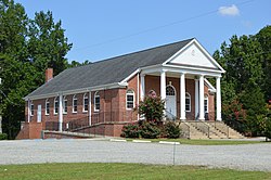
Northern Neck Baptist Church.jpg
Baptist church
USA Virginia location map.svg
Red pog.svg
Callao
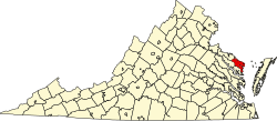
Location within the Commonwealth of Virginia
Usa edcp location map.svg
Red pog.svg
Callao
Callao (the United States)
Coordinates: 37°58′09″N76°33′35″W / 37.96917°N 76.55972°W / 37.96917; -76.55972
CountryUnited States
State Virginia
County Northumberland
Time zone UTC−5 (Eastern (EST))
  Summer (DST) UTC−4 (EDT)
GNIS feature ID1464259 [1]

Callao is an unincorporated community in Northumberland County, Virginia, United States. [1] It is located on U.S. Route 360 (the Northumberland Highway) northwest of Heathsville and east of Warsaw.

The name of the town was derived from the name of the first Postmaster, Jacob Callaway, in 1893. Callaway wanted the post office named after himself. However, there was already a town named Callaway in Virginia, so he dropped the "way" and added the "o". [2]

Wheatland was listed on the National Register of Historic Places in 1988. [3]

Related Research Articles

<span class="mw-page-title-main">Northumberland County, Virginia</span> County in Virginia, United States

Northumberland County is a county located in the Commonwealth of Virginia. At the 2020 census, the population was 11,839. Its county seat is Heathsville. The county is located on the Northern Neck and is part of the Northern Neck George Washington Birthplace AVA winemaking appellation.

<span class="mw-page-title-main">Callao, Missouri</span> City in Missouri, United States

Callao is a city in Macon County, Missouri, United States. The population was 251 at the 2020 census, down from 292 in 2010.

<span class="mw-page-title-main">Elliston, Virginia</span> CDP in Virginia, United States

Elliston is a census-designated place (CDP) in Montgomery County, Virginia, United States. It lies between the city of Roanoke and the town of Christiansburg in the southwestern part of the state. The population as of the 2010 Census was 902. It is home to a small fire department, an elementary school, two gas stations, a train stop, and several churches. Most of its residents commute to larger towns. A set of railroad tracks separates the northwestern part of the town from the rest. US highway 11-460 further divides the town into two distinct neighborhoods, "Oldtown," which formed along the Valley Road in the 1850s, and "The Brake," a predominantly African-American area that developed after the Civil War.

<span class="mw-page-title-main">Heathsville, Virginia</span> Census-designated place in Virginia, United States

Heathsville is a census-designated place (CDP) in and the county seat of Northumberland County, Virginia, United States. Heathsville is in the easternmost county of the Northern Neck of Virginia, which was the birthplace of three of the first five Presidents of the United States - George Washington, James Madison, and James Monroe. It is the county seat of Northumberland County, and has housed four county courthouses since the first was built in 1663.

<span class="mw-page-title-main">Aurora, West Virginia</span> Census-designated place in West Virginia, United States

Aurora is an unincorporated community and census-designated place in southeastern Preston County, West Virginia, United States. As of the 2010 census, its population was 201. Aurora is located on U.S. Route 50 between the Maryland state line and the town of Rowlesburg. Cathedral State Park is located to the east of Aurora's post office.

<span class="mw-page-title-main">Algoma, West Virginia</span> Unincorporated community in West Virginia, United States

Algoma is an unincorporated community in McDowell County, West Virginia, United States. Algoma is located adjacent to the town of Northfork. Its post office was established in 1891 and discontinued in 1988. Algoma most likely was derived from the Algonquin language.

<span class="mw-page-title-main">Tebbetts, Missouri</span> Census-Designated Place in Missouri, United States

Tebbetts is an unincorporated community in southern Callaway County, Missouri, United States. It is part of the Jefferson City, Missouri Metropolitan Statistical Area. Tebbetts is located on Route 94, approximately 8 miles (13 km) east of Jefferson City, on the north edge of the Missouri River floodplain.

Bloomfield is an unincorporated community in Loudoun County, Virginia. It is situated at the intersection of Airmont and Bloomfield Roads.

<span class="mw-page-title-main">Reedville, Virginia</span> Unincorporated community in Virginia, United States

Reedville is an unincorporated community in Northumberland County in the Northern Neck region of the U.S. state of Virginia. It is located at the eastern terminus of U.S. Route 360 east of Heathsville, at the head of Cockrell's Creek on the western shore of the Chesapeake Bay.

<span class="mw-page-title-main">National Register of Historic Places listings in Caroline County, Virginia</span>

This is a list of the National Register of Historic Places listings in Caroline County, Virginia.

<span class="mw-page-title-main">National Register of Historic Places listings in Hanover County, Virginia</span>

This is a list of the National Register of Historic Places listings in Hanover County, Virginia.

<span class="mw-page-title-main">National Register of Historic Places listings in Northumberland County, Pennsylvania</span>

This is a list of the National Register of Historic Places listings in Northumberland County, Pennsylvania.

<span class="mw-page-title-main">National Register of Historic Places listings in Stafford County, Virginia</span>

This is a list of the National Register of Historic Places listings in Stafford County, Virginia.

<span class="mw-page-title-main">National Register of Historic Places listings in Northumberland County, Virginia</span>

This is a list of the National Register of Historic Places listings in Northumberland County, Virginia.

<span class="mw-page-title-main">National Register of Historic Places listings in Suffolk, Virginia</span>

This is a list of the National Register of Historic Places listings in Suffolk, Virginia.

<span class="mw-page-title-main">National Register of Historic Places listings in Surry County, Virginia</span>

This is a list of the National Register of Historic Places listings in Surry County, Virginia.

<span class="mw-page-title-main">National Register of Historic Places listings in Callaway County, Missouri</span>

This is a list of the National Register of Historic Places listings in Callaway County, Missouri.

<span class="mw-page-title-main">Callaway, Virginia</span> Unincorporated community in Virginia, United States

Callaway is an unincorporated community in Franklin County, Virginia, United States. Callaway is 8.8 miles (14.2 km) west of Rocky Mount. Callaway has a post office with ZIP code 24067, which opened on July 14, 1871.

<span class="mw-page-title-main">Pompey Callaway House</span> Historic house in Virginia, United States

Pompey Callaway House is a historic home located near Elliston, Montgomery County, Virginia, United States. The house was built about 1910, and is a two-story, three bay brick dwelling with a single pile central passage plan. Its builder, Pompey Callaway, was an ex-slave from Franklin County. It is one of the most substantial houses built for an African-American owner in Montgomery County before 1920.

<span class="mw-page-title-main">Wheatland (Callao, Virginia)</span> Historic house in Virginia, United States

Wheatland is a historic plantation house located at Callao, Northumberland County, Virginia, United States. It was built between 1848 and 1850, and consists of a 2+12-story, five-bay, Federal style frame main block flanked by symmetrical 1+12-story wings. It measures 96 feet long, and is topped by a gable roof. The front and rear facades features two-tier Doric order porticos. Also on the property are the contributing kitchen, office, North Yard and South Yard houses, barn, tenant house, and early 20th century smokehouse.

References

  1. 1 2 "Callao". Geographic Names Information System . United States Geological Survey, United States Department of the Interior . Retrieved August 13, 2013.
  2. McKenney, Mike. Down Home in Calleo. Cooperative Living.
  3. "National Register Information System". National Register of Historic Places . National Park Service. July 9, 2010.