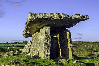
A dolmen or portal tomb is a type of single-chamber megalithic tomb,usually consisting of two or more upright megaliths supporting a large flat horizontal capstone or "table". Most date from the Late Neolithic period and were sometimes covered with earth or smaller stones to form a tumulus. Small pad-stones may be wedged between the cap and supporting stones to achieve a level appearance. In many instances,the covering has eroded away,leaving only the stone "skeleton".

The Liao River is the principal river in southern Northeast China,and one of the seven main river systems in China. Its name derived from the Liao region,a historical name for southern Manchuria,from which the Liaoning province,Liaodong Peninsula and Liao dynasty also all have derived their names. The river is also popularly known as the "mother river" in Northeast China. Coursing 1,345 kilometres (836 mi) long,the Liao River system drains a catchment basin of over 232,000 square kilometres (90,000 sq mi),but its mean discharge is quite small at only about 500 cubic metres per second (18,000 cu ft/s),about one-twentieth that of the Pearl River. The Liao River has an exceedingly high sediment load because many parts of it flow through powdery loess.

The Nen River or Nenjiang,or Nonni is a river in Northeast China. The Nen River flows through the northern part of Heilongjiang Province and the northeastern section of Inner Mongolia,some parts of the river forming the border between the two regions. At 1,370 km (850 mi) in length,the Nen River is the longest tributary of the Songhua River.

The Dadu River,known in Tibetan as the Gyelmo Ngul Chu,is a major river located primarily in Sichuan province,southwestern China. The Dadu flows from the eastern Tibetan Plateau into the Sichuan Basin where it joins with the Min River,a tributary of the Yangtze River. Measured from its geographic source,the Dadu is actually longer than the Min and thus forms the main stem of the Min River system.

Meihekou is a city of 600,000 in Jilin province,People's Republic of China. It is a regional transport hub,connecting three railway lines,all of which are single track,and 2 national highways. The city is also a major lorry transshipment point in the region as it is also the junction of two trunk roads,connected to Liaoyuan in the northwest. The city is administratively a county-level city of the prefecture-level city of Tonghua,and is its northernmost county-level division.

The Xiliao or West Liao River is a river in Inner Mongolia and Liaoning province,in northeast China. Its source is the Xilamulun River in Inner Mongolia. It is one of the headwaters of the Liao River.
The Huan River,or Anyang River (安阳河),is a river in Henan,China,and part of the Hai River basin. The river rises north of Linzhou in northwestern Henan,and joins the Wei River near Neihuang in the northeast of the province.

The Jing River or Jing He,also called Jing Shui,is a tributary of the Wei River,which in turn is the largest tributary of the Yellow River.

The Zuojiang Huashan Rock Art Cultural Landscape is an extensive assembly of historical rock art that was painted on limestone cliff faces in Guangxi,southern China. The paintings are located on the west bank of the Ming River which is a tributary of the Zuo River. The area of the paintings is part of the Nonggang Nature Reserve and belongs to Ningming County. On July 15,2016,Zuojiang Huashan Rock Art Cultural Landscape was listed as the 49th UNESCO World Heritage Site in China.

Kayue culture was a Bronze Age culture in Northwest China in the area of the upper reaches of the Yellow River and its tributary Huang Shui. It was discovered in 1923 in the villages Kayue (卡约) and Xiaxihe (下西河) of Yunguchuan Huangzhong in China's Qinghai Province and is named after the village of Kayue. The former name of the Kayue culture was Kayao culture,it was previously assigned to the Siwa culture. It is dated to the period of approximately 900 to 600 BCE.
Jade Mountain is a mythological mountain in Chinese mythology and the residence of The Queen Mother of the West.

The Yinma River is a 386.8-km-long tributary of the Second Songhua River in the center of Jilin province of China. The source of the river is located in Yitong Manchu Autonomous County and flows generally from south to north through Panshi、Jiutai、Dehui to join the Second Songhua River at Kaoshan in Nong'an County.

The Huifa River is a 267.7-km-long tributary of the Second Songhua River in center Northeast China. The source of river is located in Qingyuan Manchu Autonomous County of Liaoning Province and flows generally from west to east across Meihekou、Huinan、Huadian of Jilin Province and joins Second Songhua River at Toudaogou of Huadian City.
Lingxi is a town of Yongshun County,Hunan Province,China,and also the seat of Yongshun County,Hunan,China.

Hui River,traditionally known as Huan River or Baohui River,was a major tributary of Huai River in northern China. Currently,it flows into the Huai-Hong New Canal,a constructed flood control waterway connecting Huaiyuan and Hongze Lake. The starting point of Hui River is the ancient Honggou Canal (鸿沟),which has a great historical significance because it was the border between territories controlled by Liu Bang and Xiang Yu during the Chu-Han Contention. The river is mainly recharged by rainwater and groundwater. The river is heavily polluted by wastewater from nearby towns.
Xituanshan is a Late Bronze Age group of stone burials in Jilin,China. It was designated a Major National Historical and Cultural Site by the Chinese government in 2001.
The Huizhou dialect is a Chinese dialect spoken in and around Huicheng District,the traditional urban centre of Huizhou,Guangdong. The locals also call the dialect Bendihua and distinguish it from the dialect spoken in Meixian and Danshui,Huiyang,which they call Hakka.


