
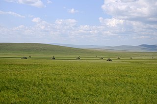
The Mongols are an East Asian ethnic group native to Mongolia, China, as well as Buryatia and Kalmykia of Russia. The Mongols are the principal member of the large family of Mongolic peoples. The Oirats in Western Mongolia as well as the Buryats and Kalmyks of Russia are classified either as distinct ethno-linguistic groups or subgroups of Mongols.

Manchuria is a term that refers to a region in Northeast Asia encompassing the entirety of present-day Northeast China, and historically parts of the modern-day Russian Far East, often referred to as Outer Manchuria. Its definition may refer to varying geographical extents as follows: the Chinese provinces of Heilongjiang, Jilin, and Liaoning but broadly also including the eastern Inner Mongolian prefectures of Hulunbuir, Hinggan, Tongliao, and Chifeng, collectively known as Northeast China; the aforementioned regions plus the homelands of ancient Jurchen and their descendant Manchus, parts of these region were ceded to the Russian Empire by the Manchu-led Qing dynasty during the Amur Annexation of 1858–1860, which include present-day Amur Oblast, Primorsky Krai, the Jewish Autonomous Oblast, the southern part of Khabarovsk Krai, and the eastern edge of Zabaykalsky Krai, collectively known as the Outer Manchuria or Russian Manchuria.
Inner Mongolia, officially the Inner Mongolia Autonomous Region, is an autonomous region of the People's Republic of China. Its border includes two-thirds of the length of China's border with the country of Mongolia. Inner Mongolia also accounts for a small section of China's border with Russia. Its capital is Hohhot; other major cities include Baotou, Chifeng, Tongliao, and Ordos.

Ulaanbaatar, previously anglicized as Ulan Bator, is the capital and most populous city of Mongolia. With a population of 1.6 million, it is the coldest capital city in the world by average yearly temperature. The municipality is located in north central Mongolia at an elevation of about 1,300 metres (4,300 ft) in a valley on the Tuul River. The city was founded in 1639 as a nomadic Buddhist monastic centre, changing location 28 times, and was permanently settled at its modern location in 1778.

Turkestan, also spelled Turkistan, is a historical region in Central Asia corresponding to the regions of Transoxiana and East Turkistan (Xinjiang). Turkestan is primarily inhabited by Turkic peoples, including Uzbeks, Oghuz Turks, Kazakhs, Khazars, Kyrgyz, and Uyghurs. The region hosts Russian and Tajik-Persian minorities. Turkestan is subdivided into Afghan Turkestan, Russian Turkestan, and East Turkistan. Today, "Turkestan" mainly refers to Xinjiang, where Turkic peoples constitute more than half of the population.

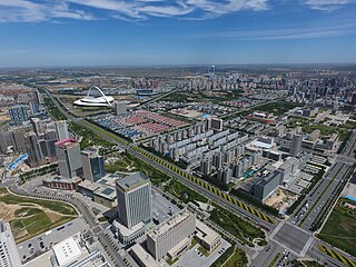
Hohhot, formerly known as Kweisui, is the capital of Inner Mongolia in the north of the People's Republic of China, serving as the region's administrative, economic and cultural center. Its population was 3,446,100 inhabitants as of the 2020 census, of whom 2,944,889 lived in the metropolitan area consisting of 4 urban districts plus the Tümed Left Banner.

Zhenjiang, alternately romanized as Chinkiang, is a prefecture-level city in Jiangsu Province, China. It lies on the southern bank of the Yangtze River near its intersection with the Grand Canal. It is opposite Yangzhou and between Nanjing and Changzhou. Zhenjiang was formerly the provincial capital of Jiangsu and remains as an important transportation hub. As of the 2020 census, its total population was 3,210,418 inhabitants whom 1,266,790 lived in the built-up area made of the 3 urban districts. The town is best known both in China and abroad for Chinkiang vinegar, a fragrant black vinegar that is a staple of Chinese cooking.
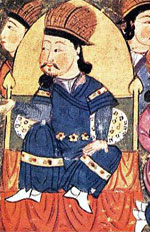
Altan Khan of the Tümed, whose given name was Anda, was the leader of the Tümed Mongols de facto ruler of the Right Wing, or western tribes, of the Mongols, and the first Ming Shunyi King (顺义王). He was the grandson of Dayan Khan (1464–1543), a descendant of Kublai Khan (1215–1294), who had managed to unite a tribal league between the Khalkha Mongols in the north and the Chahars (Tsakhars) to the south. His name means "Golden Khan" in the Mongolian language.

Khanbaliq or Dadu of Yuan was the winter capital of the Yuan dynasty of China in what is now Beijing, the capital of China today. It was located at the center of modern Beijing. The Secretariat directly administered the Central Region of the Yuan dynasty and dictated policies for the other provinces. As emperors of the Yuan dynasty, Kublai Khan and his successors also claimed supremacy over the entire Mongol Empire following the death of Möngke in 1259. Over time the unified empire gradually fragmented into a number of khanates.

Zhangjiakou, also known as Kalgan and by several other names, is a prefecture-level city in northwestern Hebei province in Northern China, bordering Beijing to the southeast, Inner Mongolia to the north and west, and Shanxi to the southwest. By 2019, its population was 4,650,000 inhabitants on 36,861.56 square kilometres (14,232.33 sq mi), divided into 17 Counties and Districts. The built-up area made of Qiaoxi, Qiaodong, Chongli, Xuanhua, Xiahuayuan Districts largely being conurbated had 1,500,000 inhabitants in 2019 on 1,412.7 km2 (545.4 sq mi).

Khovd, formerly known as Kobdo or Khobdo, is the capital of the Khovd Province of Mongolia. It is the administrative seat of the Jargalant sum.
Ordos, also known as Ih Ju, is one of the twelve major subdivisions of Inner Mongolia, China. It lies within the Ordos Plateau of the Yellow River. Although mainly rural, Ordos is administered as a prefecture-level city. Its population was 2,153,638 as of the 2020 census, and its built-up area made up of Ejin Horo Banner and Kangbashi District was home to 366,779 inhabitants, as Dongsheng District is not a conurbation yet.

Buddhism is the largest religion in Mongolia practiced by 51.7% of Mongolia's population, according to the 2020 Mongolia census. Buddhism in Mongolia derives much of its recent characteristics from Tibetan Buddhism of the Gelug and Kagyu lineages, but is distinct and presents its own unique characteristics.

Mongolia under Qing rule was the rule of the Manchu-led Qing dynasty of China over the Mongolian Plateau, including the four Outer Mongolian aimags and the six Inner Mongolian aimags from the 17th century to the end of the dynasty. The term "Mongolia" is used here in the broader historical sense, and includes an area much larger than the modern-day state of Mongolia. By the early 1630s Ligdan Khan saw much of his power weakened due to the disunity of the Mongol tribes. He was subsequently defeated by the Later Jin dynasty and died soon afterwards. His son Ejei handed the Yuan imperial seal over to Hong Taiji in 1635, thus ending the rule of the Northern Yuan dynasty in Inner Mongolia. However, the Khalkha Mongols in Outer Mongolia continued to rule until they were overrun by the Dzungar Khanate in 1690, and they submitted to the Qing dynasty in 1691.

The Mongolian Revolution of 1911 occurred when the region of Outer Mongolia declared its independence from the Manchu-led Qing China during the Xinhai Revolution. A combination of factors, including economic hardship and failure to resist Western imperialism, led many in China to be unhappy with the Qing government. When a new program to settle Mongolia with ethnic Han and assimilate the natives was unveiled, it was met with resistance that resulted in a relatively bloodless separation from the Qing Empire. Many Barga and Inner Mongolian chieftains assisted in the revolution and became the revolution leaders.
Zhenning Buyei and Miao Autonomous County is an autonomous county under the administration of the prefecture-level city of Anshun, in the southwest of Guizhou Province, China.
Various nomadic empires, including the Xiongnu, the Xianbei state, the Rouran Khaganate (330–555), the First (552–603) and Second Turkic Khaganates (682–744) and others, ruled the area of present-day Mongolia. The Khitan people, who used a para-Mongolic language, founded an empire known as the Liao dynasty (916–1125), and ruled Mongolia and portions of North China, northern Korea, and the present-day Russian Far East.

Chengguan, also known as Huangyuan and by other names, is a town on the Huangshui River in Qinghai, China. It serves as the seat of Huangyuan County, lying about 45 km (28 mi) upstream (west) from the provincial capital of Xining and approximately 45 km (28 mi) east of Qinghai Lake. Chengguan has a 600-year history as a frontier trading post between the Chinese, Mongolian, and Tibetan cultural spheres.
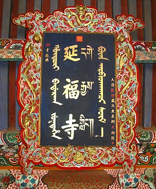
Yanfu Temple, more commonly known as Prince Temple, is a Buddhist temple located in Alxa Left Banner, Alxa League, Inner Mongolia China. Yanfu Temple is considered one of the Three Great Buddhist Temples in Alxa League, alongside Fuyin Temple and Guangzong Temple.

Carthage was captured by the Vandals from the Western Roman Empire on 19 October 439. Under their leader Genseric, the Vandals crossed the Strait of Gibraltar into Africa and captured Hippo Regius in August 431, which they made the capital of their kingdom. Despite an uneasy peace with the Romans, Genseric made a surprise attack against Carthage in October 439. After capturing Carthage, the Vandals put the city to the sack and made it the new capital of their kingdom.
