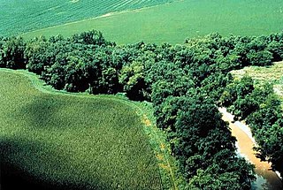
A floodplain or flood plain or bottomlands is an area of land adjacent to a river which stretches from the banks of its channel to the base of the enclosing valley walls, and which experiences flooding during periods of high discharge. The soils usually consist of clays, silts, sands, and gravels deposited during floods.

Flushing Meadows–Corona Park, often referred to as Flushing Meadows Park, or simply Flushing Meadows, is a public park in the northern part of Queens, New York City. It is bounded by I-678 on the east, Grand Central Parkway on the west, Flushing Bay on the north, and Union Turnpike on the south. Flushing Meadows–Corona Park is the fourth-largest public park in New York City, with a total area of 897 acres (363 ha).

Sint-Michielsgestel is a municipality in the southern part of the Netherlands. It is named for the village of Sint-Michielsgestel located within its boundaries.

Sint-Oedenrode is a town in the province of North Brabant.

A hedge or hedgerow is a line of closely spaced shrubs and sometimes trees, planted and trained to form a barrier or to mark the boundary of an area, such as between neighbouring properties. Hedges that are used to separate a road from adjoining fields or one field from another, and are of sufficient age to incorporate larger trees, are known as hedgerows. Often they serve as windbreaks to improve conditions for the adjacent crops, as in bocage country. When clipped and maintained, hedges are also a simple form of topiary.

The Gender is a stream in the Dutch province of North Brabant. It originates in originally marshy flatlands near Steensel and flows through Veldhoven and its eastern district Meerveldhoven in a general east-northeast direction towards Eindhoven.

The Bijlands Kanaal is a canal in the Dutch province of Gelderland, near the Dutch-German border. It is currently by far the most important river-stretch of the Rhine when that major river enters the Netherlands.

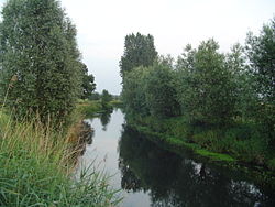
The Dommel is a small river in Belgium and the Netherlands, left tributary of the Dieze. It is 120 km long, of which 85 km in the Netherlands. The Dommel takes in water from the Keersop, Tongelreep, Run, Gender and Kleine Dommel streams and merges at 's-Hertogenbosch with the Aa stream to form the river Dieze, which subsequently flows towards the Meuse. The main cities and towns along the Dommel's course are Peer, Neerpelt, Valkenswaard, Dommelen, Eindhoven, Son en Breugel, Sint-Oedenrode, Boxtel, Sint-Michielsgestel and 's-Hertogenbosch.

A water-meadow is an area of grassland subject to controlled irrigation to increase agricultural productivity. Water-meadows were mainly used in Europe from the 16th to the early 20th centuries. Working water-meadows have now largely disappeared, but the field patterns and water channels of derelict water-meadows remain common in areas where they were used, such as parts of Northern Italy, Switzerland and England. Derelict water-meadows are often of importance as wetland wildlife habitats.
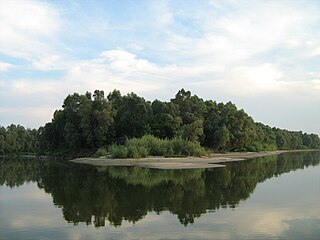
A riparian zone or riparian area is the interface between land and a river or stream. Riparian is also the proper nomenclature for one of the terrestrial biomes of the Earth. Plant habitats and communities along the river margins and banks are called riparian vegetation, characterized by hydrophilic plants. Riparian zones are important in ecology, environmental resource management, and civil engineering because of their role in soil conservation, their habitat biodiversity, and the influence they have on fauna and aquatic ecosystems, including grasslands, woodlands, wetlands, or even non-vegetative areas. In some regions, the terms riparian woodland, riparian forest, riparian buffer zone,riparian corridor, and riparian strip are used to characterize a riparian zone. The word riparian is derived from Latin ripa, meaning "river bank".
Ashford Green Corridor is a green space that runs through the town of Ashford in Kent, England. The Green Corridor is made up of parks, recreation grounds and other green spaces alongside the rivers that flow through Ashford. It is a Local Nature Reserve.

The University of Guelph Arboretum was formally established in 1970 by the University of Guelph. The Arboretum aims to conserve biodiversity and connect people with nature through teaching, research, and community outreach. The 165 hectare space serves as an “outdoor learning resource,” a “living laboratory” and a “community resource”. The Arboretum is open all year round to the public from dawn to dusk, and admission is free. It is used for a wide array of purposes such as teaching, research, conservation, recreation, school programs, adult workshops, and walking tours. It is also a popular place for weddings and ceremonies. There are more than 40 collections of woody plants for academic and display purposes, as well as various display gardens, memorial plantings, and facilities. The University of Guelph Arboretum is a member of the American Public Gardens Association and the Society for Ecological Restoration. These memberships and programs allow the Arboretum to work cooperatively towards a variety of biodiversity and conservation goals. Additionally, the Arboretum is one of the 38 Arbnet Level 4 accredited arboretums around the world. The Arboretum and University of Guelph sit on Dish with One Spoon territory, treaty lands of the Mississaugas of the Credit, and the Between the Lakes Treaty 3 lands. Continuing to care for the rich natural heritage of this land in a sustainable manner is part of the Arboretum’s vision. It is visited by approximately 100,000 people annually.
Gornje Podunavlje Special Nature Reserve is a large protected area of wetland in the northwest of Serbia, on the Danube's left bank. It comprises two large marshes, Monoštorski Rit and Apatinski Rit and vast forests, meadows, ponds, swamps and the Danube's meanders, including 66 km (41 mi) of the Danube course. It is a part of the trans-boundary biosphere reserve "Mura-Drava-Danube", a five country project, dubbed the "Amazon of Europe".

The Tongelreep is a small tributary of the Dommel that flows through Belgium and the Netherlands. It begins in Belgium near Neerpelt and runs into the Dommel in Eindhoven by way of Valkenswaard and Aalst. The stream runs near the Achel Abbey, the Leenderbos, the Valkenhorst estates and the Genneper Parken park area.

Frays Farm Meadows is a 28.2-hectare (70-acre) biological Site of Special Scientific Interest near Denham in the London Borough of Hillingdon. It was notified as an SSSI in 1981, and has been managed by the London Wildlife Trust on behalf of Hillingdon Council since 1999. It is part of the Colne Valley Regional Park.

Old River Severn, Upper Lode is a 3.72-hectare (9.2-acre) biological Site of Special Scientific Interest in Gloucestershire, notified in 1985. It is a cross county border site between Gloucestershire and Herefordshire and Worcestershire.
Nijnsel is a village in the province of North Brabant, located in the Meierij of 's-Hertogenbosch. Nijnsel is a parish of the municipality of Meierijstad.

The Moerkuilen are, along with the Dommelbeemden a forestry area in a bend of the Dommel river north east of Nijnsel in Meierijstad. It is located at the Lieshoutse Dijk, not far from the A50 motorway. The protected area measures over 100 acres and connects with the Vresselse Bossen in the south. The Moerkuilen are part of the larger area Het Groene Woud.

Het Groene Woud is a special area of the Netherlands which is located in North Brabant between the cities of Tilburg, Eindhoven and 's-Hertogenbosch. It includes nature reserves such as the Kampina, the Oisterwijk forests and fens, Velderbos and the Dommel.

The Kleine Dommel or Rul is a brook in the Campine and Meierij van 's-Hertogenbosch, Netherlands.