
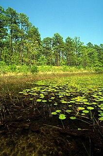
Peat, also known as turf, is an accumulation of partially decayed vegetation or organic matter. It is unique to natural areas called peatlands, bogs, mires, moors, or muskegs. The peatland ecosystem covers 3.7 million square kilometres (1.4 million square miles) and is the most efficient carbon sink on the planet, because peatland plants capture carbon dioxide (CO2) naturally released from the peat, maintaining an equilibrium. In natural peatlands, the "annual rate of biomass production is greater than the rate of decomposition", but it takes "thousands of years for peatlands to develop the deposits of 1.5 to 2.3 m [4.9 to 7.5 ft], which is the average depth of the boreal [northern] peatlands", which store around 415 gigatonnes (Gt) of carbon (about 46 times 2019 global CO2 emissions). Globally, peat stores up to 550 Gt of carbon, 42% of all soil carbon, which exceeds the carbon stored in all other vegetation types, including the world's forests, although it covers just 3% of the land's surface. Sphagnum moss, also called peat moss, is one of the most common components in peat, although many other plants can contribute. The biological features of sphagnum mosses act to create a habitat aiding peat formation, a phenomenon termed 'habitat manipulation'. Soils consisting primarily of peat are known as histosols. Peat forms in wetland conditions, where flooding or stagnant water obstructs the flow of oxygen from the atmosphere, slowing the rate of decomposition. Peat properties such as organic matter content and saturated hydraulic conductivity can exhibit high spatial heterogeneity.

The Dommel is a small river in Belgium and the Netherlands, left tributary of the Dieze. It is 120 km long, of which 85 km in the Netherlands. The Dommel takes in water from the Keersop, Tongelreep, Run, Gender and Kleine Dommel streams and merges at 's-Hertogenbosch with the Aa stream to form the river Dieze, which subsequently flows towards the Meuse. The main cities and towns along the Dommel's course are Peer, Neerpelt, Valkenswaard, Dommelen, Eindhoven, Son en Breugel, Sint-Oedenrode, Boxtel, Sint-Michielsgestel and 's-Hertogenbosch.

The Kootenai National Forest is a national forest located in the far northwestern section of Montana and the northeasternmost lands in the Idaho panhandle in the United States, along the Canada–US border. Of the 2.2 million acres (8,900 km2) administered by the forest, less than 3 percent is located in the state of Idaho. Forest headquarters are located in Libby, Montana. There are local ranger district offices in Eureka, Fortine, Libby, Trout Creek, and Troy, Montana. About 53 percent of the 94,272-acre (381.51 km2) Cabinet Mountains Wilderness is located within the forest, with the balance lying in neighboring Kaniksu National Forest.

Mount Makiling, or Mount Maquiling, is an inactive stratovolcano located in the provinces of Laguna and Batangas on the island of Luzon, Philippines. The mountain rises to an elevation of 1,090 m (3,580 ft) above mean sea level and is the highest feature of the Laguna Volcanic Field. The volcano has no recorded historic eruption but volcanism is still evident through geothermal features like mud spring and hot springs. South of the mountain is the Makiling-Banahaw Geothermal Plant. The Philippine Institute of Volcanology and Seismology (PHIVOLCS) classifies the volcano as "Inactive".

Delamere Forest is a large wood in the village of Delamere in Cheshire, England. The woodland, which is managed by Forestry England, covers an area of 972 hectares making it the largest area of woodland in the county. It contains a mixture of deciduous and evergreen trees.

Nettetal is a municipality in the district of Viersen, North Rhine-Westphalia, Germany. It is situated in the Lower Rhine region.

Drawa National Park is located in north-western Poland, on the border of Greater Poland, Lubusz and West Pomeranian Voivodeships. The park is a part of the huge Drawsko Forest, which lies on the vast Drawsko Plain. It takes its name from the River Drawa. It was created in 1990 and initially covered 86.91 km². Later, it was enlarged to 113.42 square kilometres (43.79 sq mi) of which forests account for 96.14 km², and water bodies cover 9.37 km².

The Minnesota Department of Natural Resources, or Minnesota DNR, is the agency of the U.S. state of Minnesota charged with conserving and managing the state's natural resources. The agency maintains areas such as state parks, state forests, recreational trails, and recreation areas as well as managing minerals, wildlife, and forestry throughout the state. The agency is divided into six divisions - Ecological & Water Resources, Enforcement, Fish & Wildlife, Forestry, Lands & Minerals, and Parks & Trails.

The Borneo peat swamp forests ecoregion, within the tropical and subtropical moist broadleaf forests biome, are on the island of Borneo, which is divided between Brunei, Indonesia and Malaysia.

The Blackwater River of Florida is a 56.6-mile-long (91.1 km) river rising in southern Alabama and flowing through the Florida Panhandle to the Gulf of Mexico. The river enters Florida in Okaloosa County and flows through Santa Rosa County to Blackwater Bay, an arm of Pensacola Bay. The river passes through Blackwater River State Forest and Blackwater River State Park. Milton, the county seat of Santa Rosa County, is located on the river.
Clearwater Wilderness, a small 14,300-acre (5,800 ha) wilderness area in the North Cascades mountain range, in northern Washington state, of the Northwestern United States. It is located in the Mount Baker-Snoqualmie National Forest, and southeast of Tacoma in northeastern Pierce County.
The Croatan National Forest is a U.S. National Forest, was established on July 29, 1936, and is located on the Atlantic coast of North Carolina. It is administered by the United States Forest Service, a part of the United States Department of Agriculture. The forest is managed together with the other three North Carolina National Forests from common headquarters in Asheville, North Carolina. However, Croatan has a local ranger district office in New Bern.

Canada's boreal forest is a vast region comprising about one third of the circumpolar boreal forest that rings the Northern Hemisphere, mostly north of the 50th parallel. Other countries with boreal forest include Russia, which contains the majority; the United States in its northernmost state of Alaska; and the Scandinavian or Northern European countries. In Europe, the entire boreal forest is referred to as taiga, not just the northern fringe where it thins out near the tree line. The boreal region in Canada covers almost 60% of the country's land area. The Canadian boreal region spans the landscape from the most easterly part of the province of Newfoundland and Labrador to the border between the far northern Yukon and Alaska. The area is dominated by coniferous forests, particularly spruce, interspersed with vast wetlands, mostly bogs and fens. The boreal region of Canada includes eight ecozones. While the biodiversity of regions varies, each ecozone has a characteristic native flora and fauna.

The Kahayan river, or Great Dayak River, is the second largest river after Barito River in Central Kalimantan, a province of Indonesia in Kalimantan – the Indonesian part of the island of Borneo. With a total length of 658 km (409 mi) and with a drainage basin of 15,500 km2 (6,000 sq mi) in South Kalimantan, Indonesia. Mean annual discharge 1,178 m3/s (41,600 cu ft/s). The provincial capital Palangkaraya lies on the river. The main inhabitants are Dayaks, who practice slash-and-burn rice cultivation and pan for gold on the upper reaches. The lower Kayahan flows through a rich and unusual environment of peat swamp forests, which has been severely degraded by an unsuccessful program to convert a large part of the area into rice paddies, compounded by legal and illegal forestry.

Bắc Kạn, also spelt Bắc Cạn, is a province of Vietnam. It is located in the Northeast region, due north of the capital Hanoi. Bắc Kạn is the only town of the province which is the capital of the province and is a municipality. The province covers an area of 4,859.4 square kilometres and as of 2019 it had a population of 313,905 people. It is a mountainous terrain with rich natural resources of minerals and forests. It has numerous mountains, rivers and lakes which are very scenic. Ba Bể National Park and Ba Bể Lake lie within its borders.

Nijnsel is a village in the province of North Brabant, located in the Meierij of 's-Hertogenbosch. Nijnsel is a parish of the municipality of Meierijstad.
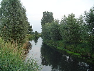
The Dommelbeemden are, along with the Moerkuilen a forestry area in a bend of the Dommel river northeast of Nijnsel in Meierijstad. It is located at the Lieshoutse Dijk, not far from the A50 motorway. The protected area measures over 100 acres. The Dommelbeemden are part of the larger area Het Groene Woud.

Het Groene Woud is a special area of the Netherlands which is located in North Brabant between the cities of Tilburg, Eindhoven and 's-Hertogenbosch. It includes nature reserves such as the Kampina, the Oisterwijk forests and fens, Velderbos and the Dommel.

Meshchyora National Park covers extensive wetlands and pine/birch woodlands in the Meshchera Lowlands on the East European Plain in Vladimir Oblast, about 120 km east of Moscow. The wetland habitat provides for extremely rich biodiversity among the plants and animals. The area is associated with the medieval Meshchera tribe, from which the area takes its name. "Meshchyora" National Park (Мещёра) is not to be confused with "Meshchersky" (Мещёрский) National Park, which is just to the south, over the border in Ryazan Oblast. The Meshchyora NP is located entirely within the Oka River watershed. A small corner of the park touches on the border of the Moscow region. About 39% of the park territory is used and managed for agricultural purposes by local communities.
Princess Sirindhorn Wildlife Sanctuary, or popularly known as Pa Phru To Daeng (ป่าพรุโต๊ะแดง), or just called Phru To Daeng (พรุโต๊ะแดง) is a largest and most fertile peat swamp forest in Thailand covering an area of 125,625 rais, about 4.9654 km2 (49,654 a) in Mueang Narathiwat, Tak Bai, Su-ngai Kolok, and Su-ngai Padi districts of Narathiwat province in southern Thailand. It is about 6 km from Su-ngai Kolok railway station.
