
Macquarie Pass National Park is a national park in New South Wales, Australia, 90 km southwest of Sydney. It is located around the pass of the same name, which is on the Illawarra Highway and part of the Illawarra escarpment.

Interstate 86 (I-86) is an east–west intrastate Interstate Highway located entirely within the state of Idaho. It runs approximately 63 miles (101 km) from an intersection with I-84 east of Declo in rural Cassia County, to an intersection with I-15 in Chubbuck, just north of Pocatello. The highway is part of the main route from Boise and Twin Falls to Idaho Falls and the upper Snake River region.

Reliance Infrastructure Limited (R-Infra), formerly Reliance Energy Limited (REL) and Bombay Suburban Electric Supply (BSES), is an Indian private sector enterprise involved in power generation, infrastructure, construction and defence. It is part of the Reliance Anil Dhirubhai Ambani Group. The company is headed by its chairman, Anil Ambani, and chief executive officer, Punit Narendra Garg. The corporate headquarters is in Navi Mumbai. Reliance Infrastructure's interests are in the fields of power plants, metro rail, airports, bridges, toll roads, and defence. It is a major shareholder in the other group company, Reliance Power and Reliance Naval and Engineering Limited.

Ramagundam is a city and municipal corporation in Peddapalli district of the Indian state of Telangana. It is the most populous city in the district and falls under the Peddapalli revenue division. It is located on the banks of the Godavari River. As of the 2011 census, the city had a population of 229,644, making it the 6th most populous in the state, and an urban agglomeration population of 242,979. It is located about 225 km from the state capital Hyderabad.

Banihal local pronunciation[ banhal ]is a town and a notified area committee, near Ramban town in Ramban district in the Indian union territory of Jammu and Kashmir. It is a rural and hilly area with Kamirwah being one of the most prominent hills. It is located about 35 km (22 mi) away from Qazigund of Anantnag district on NH 44. However, the distance between Banihal and Qazigund is only 18 km by train on the new railway line which is much shorter than the road. The most common language spoken in the region is Kashmiri; Urdu, Hindi, Gujjari, Pahari and English being other familiar languages. Banihal forms the main gateway to the valley of Kashmir. Some famous visiting places in banihal are Neel top and Mahu valley.

Interstate 5 (I-5) is an Interstate Highway on the West Coast of the United States that serves as the region's primary north–south route. It spans 277 miles (446 km) across the state of Washington, from the Oregon state border at Vancouver, through the Puget Sound region, to the Canadian border at Blaine. Within the Seattle metropolitan area, the freeway connects the cities of Tacoma, Seattle, and Everett.

Noida International Airport, also known as Jewar International Airport, is an upcoming international airport being constructed near Jewar in Gautam Buddha Nagar District, Uttar Pradesh in India, which will serve the National Capital Region (NCR). Once completed, it will be an alternative to Indira Gandhi International Airport in Delhi by relieving its high and rising traffic load, and is planned to be India's largest airport. The Noida International Airport Limited (NIAL) will be the implementing agency on behalf of the Government of Uttar Pradesh. The airport is to be developed through a public-private partnership model (PPP). In 2019, Flughafen Zürich AG, the operator of Zurich Airport in Switzerland won the bid to build and operate the airport for 40 years. The National Highways Authority of India (NHAI) is also constructing a 31-kilometre long (19 mi) greenfield highway from the airport to Sector-65, Faridabad on Delhi–Mumbai Expressway.
The Eastern Peripheral Expressway (EPE) or Kundli–Ghaziabad–Palwal Expressway is a 135 km (84 mi) long, 6-lane wide expressway passing through the states of Haryana and Uttar Pradesh in India. The expressway starts from the Western Peripheral Expressway at Kundli, Sonipat, passing through Baghpat, Ghaziabad and Noida districts in UP and Faridabad district in Haryana before rejoining the Western Peripheral Expressway near Dholagarh, Palwal. Eastern Peripheral Expressway along with Western Peripheral Expressway completes the largest Ring Road around Delhi. The Eastern Peripheral Expressway was declared as National Expressway 2 (NE-2) in March 2006.
The State Highway 59 (SH-59) is a proposed state highway in Kerala. It will be the longest highway in Kerala, extending from Nandarapadavu in Kasaragod district to Parassala in Thiruvananthapuram district, will have a length of 1332.16 km and will pass through 13 of the 14 districts, the exception being Alappuzha as that district is not part of the hilly ranges of Kerala. The expected outlay for the project is Rs.1,500 crore.

The Chenab Valley is a river valley formed by the Chenab River. The term is also used collectively for Doda, Kishtwar and Ramban districts of Jammu Division in Jammu and Kashmir, India. These districts were formerly part of a single district, called Doda.

Thathri is a town and a notified area committee in Doda district in the Indian union territory of Jammu and Kashmir. Thathri valley is located in the foothills of the Himalayan mountains, about 85 km from Batote. Apart from having ample forests, the town contains many small streams flowing through its various parts. It is located on the banks of the Chenab River and the town area is spread over 1.50 sq. Km².
National Highway 244 is a National Highway in India. It is located entirely within the union territory of Jammu and Kashmir. It was originally called National Highway 1B.
The Delhi–Mumbai Expressway is a 1,350 km long, 8-lane wide under-construction access-controlled expressway connecting India's national capital New Delhi with its financial capital Mumbai. Foundation stone of the project was laid by union minister Nitin Gadkari in presence of Sushma Swaraj and Arun Jaitley on 8 March 2019. The total project value including the land acquisition cost is around ₹1,00,000 crores. An additional 31 km long spur will also be constructed by the NHAI from Noida International Airport in Jewar to Sector-65, Faridabad on this expressway.
The Trans–Haryana Expressway or the Ambala–Narnaul Expressway (NH-152D) is a 227-km long, 6-lane wide greenfield access-controlled expressway, connecting the cities of Ambala and Narnaul in the state of Haryana. The expressway connects Gangheri village in Kurukshetra district with Surana village on Narnaul Bypass (NH-148B) in Mahendragarh district. It passes via Kaul, Pundri, Assandh, Dhatrath, Kalanaur, Charkhi Dadri and Kanina. It will reduce the distance from Chandigarh to Delhi, Narnaul, and Jaipur, thus decongesting NH-44 and NH-48.
Zea Abad, is a village in Thathri sub division of Doda district. It is the part of panchayat Jangalwar located on the Batote-Kishtwar National Highway.
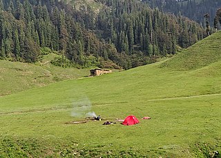
Bhal Padri is a hill station situated above a group of small valleys covered with a dense forest located in the Changa, Bhalessa. area of Doda district. It borders Padri Pass, Bhaderwah at a distance of 4 kilometres (2.5 mi) northeast. Rivulets and streams flow through this valley.

Bhalessa is a geographical area within Doda district in the Jammu region of India-administered Kashmir. It consists of the Bunjwah and Bhalessa Valleys, and comprises the three Tehsils of Kahara, Chilly Pingal and Gandoh.

Kahara is a village and tehsil in Doda district, Jammu, India. It is situated between mountainous cliffs 13 kilometres (8.1 mi) from Thathri on the Thathri-Gandoh road.
Bunjwah is a region and tehsil located in the Kishtwar district of Jammu and Kashmir, India. It comprises nine panchayat and two nayabats; it became a tehsil in 2014.
Phagsoo is a village and tehsil in the Doda district of the Jammu division of Jammu and Kashmir, India. It was previously part of the Thathri tehsil.
