
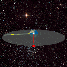
A geosynchronous orbit is an Earth-centered orbit with an orbital period that matches Earth's rotation on its axis, 23 hours, 56 minutes, and 4 seconds. The synchronization of rotation and orbital period means that, for an observer on Earth's surface, an object in geosynchronous orbit returns to exactly the same position in the sky after a period of one sidereal day. Over the course of a day, the object's position in the sky may remain still or trace out a path, typically in a figure-8 form, whose precise characteristics depend on the orbit's inclination and eccentricity. A circular geosynchronous orbit has a constant altitude of 35,786 km (22,236 mi).
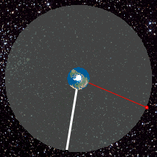
A geostationary orbit, also referred to as a geosynchronous equatorial orbit (GEO), is a circular geosynchronous orbit 35,786 km (22,236 mi) in altitude above Earth's equator, 42,164 km (26,199 mi) in radius from Earth's center, and following the direction of Earth's rotation.

A communications satellite is an artificial satellite that relays and amplifies radio telecommunication signals via a transponder; it creates a communication channel between a source transmitter and a receiver at different locations on Earth. Communications satellites are used for television, telephone, radio, internet, and military applications. Many communications satellites are in geostationary orbit 22,236 miles (35,785 km) above the equator, so that the satellite appears stationary at the same point in the sky; therefore the satellite dish antennas of ground stations can be aimed permanently at that spot and do not have to move to track the satellite. Others form satellite constellations in low Earth orbit, where antennas on the ground have to follow the position of the satellites and switch between satellites frequently.
Syncom started as a 1961 NASA program for active geosynchronous communication satellites, all of which were developed and manufactured by the Space and Communications division of Hughes Aircraft Company. Syncom 2, launched in 1963, was the world's first geosynchronous communications satellite. Syncom 3, launched in 1964, was the world's first geostationary satellite.

Dong Fang Hong 1, in the western world also known as China 1 or PRC 1, was the first space satellite of the People's Republic of China (PRC), launched successfully on 24 April 1970 as part of the PRC's Dongfanghong space satellite program. It was a part of the "Two Bombs, One Satellite" program. At 173 kg (381 lb), it was heavier than the first satellites of other countries. The satellite carried a radio transmitter which broadcast the then de facto national anthem of the same name. The broadcast lasted for 20 days while in orbit.
Dongfanghong was a satellite program of the People's Republic of China. The program started in August 1965 as Project 651—a less ambitious successor to the earlier Project 581—with the goal of launching a satellite heavier than both Sputnik 1 and Explorer 1 into space, and developing all the necessary technologies to do so.
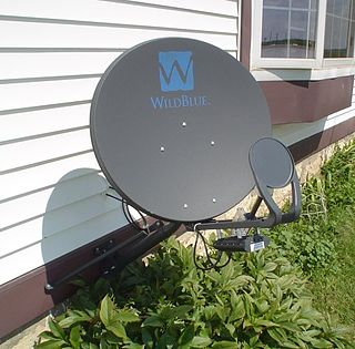
Satellite Internet access is Internet access provided through communication satellites; if it can sustain high speeds, it is termed satellite broadband. Modern consumer grade satellite Internet service is typically provided to individual users through geostationary satellites that can offer relatively high data speeds, with newer satellites using the Ku band to achieve downstream data speeds up to 506 Mbit/s. In addition, new satellite internet constellations are being developed in low-earth orbit to enable low-latency internet access from space.

Fēngyún are China's meteorological satellites. Launched since 1988 into polar Sun-synchronous and geosynchronous orbit, each three-axis stabilized Fengyun satellite is built by the Shanghai Academy of Spaceflight Technology (SAST) and operated by the China Meteorological Administration (CMA). To date, China has launched twenty-one Fengyun satellites in four classes. Fengyun 1 and Fengyun 3 satellites are in polar, Sun-synchronous orbit and Low Earth orbit while Fengyun 2 and 4 are geosynchronous orbit.
AMOS-1, then Intelsat 24, was a commercial communications satellite which was operated by Spacecom as AMOS-1, for Affordable Modular Optimized Satellite and formed part of the AMOS series of satellites. It was the first Israeli civilian communications satellite, and was initially positioned at 4° West longitude in geostationary orbit. Then in September 2011, it was moved to 31° East.
IndoStar-1, also known as Cakrawarta-1, was a communication satellite that was launched the evening of November 12, 1997 at 21:48 GMT aboard an Ariane 44L-3 rocket from Kourou, French Guiana. As the first direct broadcasting satellite (DBS) in Asia, IndoStar-1 would initiate a new communication service for Indonesian society such as direct-to-home television.
A geosynchronous satellite is a satellite in geosynchronous orbit, with an orbital period the same as the Earth's rotation period. Such a satellite returns to the same position in the sky after each sidereal day, and over the course of a day traces out a path in the sky that is typically some form of analemma. A special case of geosynchronous satellite is the geostationary satellite, which has a geostationary orbit – a circular geosynchronous orbit directly above the Earth's equator. Another type of geosynchronous orbit used by satellites is the Tundra elliptical orbit.
ChinaSat is the brand name of communications satellites operated by China Satellite Communications.
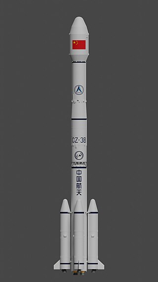
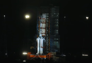
The Long March 3B, also known as the CZ-3B and LM-3B, is a Chinese orbital launch vehicle. Introduced in 1996, it is launched from Launch Area 2 and 3 at the Xichang Satellite Launch Center in Sichuan. A three-stage rocket with four strap-on liquid rocket boosters, it is the heaviest variant of the Long March 3 rocket family, and is mainly used to place communications satellites and navigation satellites into geosynchronous orbits.
The initialism STTW may stand for:
Paksat-1R is a geosynchronous, communications satellite that was manufactured by China Great Wall Industry Corporation (CGWIC) and operated by the Space and Upper Atmosphere Research Commission (SUPARCO), an executive space authority of the Government of Pakistan.
Sino Satellite Communications Co., Ltd. known also as SinoSat is a Chinese company.
Dong Fang Hong was a space satellite program in the People's Republic of China.
Alcomsat-1 is the first Algerian communications satellite. It was carried by Chinese launcher Long March 3B from the Xichang Satellite Launch Center, located in Sichuan Province, 2,200 km southwest of Beijing.
Shijian is a series of satellites built and operated by the People's Republic of China. Some Shijian-series satellites have drawn significant concerns from the United States government and space observers who cite unannounced launches, undisclosed sub-satellites deployed in orbit, unusual orbital maneuvers, and demonstrated rendezvous proximity operations (RPO) including the close inspection and towing of other satellites.
Tongxin Jishu Shiyan is a Chinese military satellite program operating in geostationary orbit (GEO). TJS satellites are manufactured by the Shanghai Academy of Spaceflight Technology (SAST) and launched from Xichang Satellite Launch Center (XSLC) in China's southern Sichuan Province. TJS is likely the cover name for multiple geostationary military satellite programs and should not be confused with the similarly named Shiyan satellite program.