Suncheon (Suncheon-si) is the largest city in Jeollanam-do, South Korea, with a population of 280,719 as of 2022. It is located in the southeast of the province and is a scenic agricultural and industrial city, known for tourist attractions, such as Suncheon Bay. The port city of Yeosu is around forty minutes south of Suncheon and Gwangyang twenty minutes to the east of the city.

Gyeongju, historically known as Seorabeol, is a coastal city in the far southeastern corner of North Gyeongsang Province, South Korea. It is the second largest city by area in the province after Andong, covering 1,324 km2 (511 sq mi) with a population of 264,091 people as of December 2012. Gyeongju is 370 km (230 mi) southeast of Seoul, and 55 km (34 mi) east of Daegu. The city borders Cheongdo and Yeongcheon to the west, Ulsan to the south and Pohang to the north, while to the east lies the coast of the Sea of Japan. Numerous low mountains—outliers of the Taebaek range—are scattered around the city.

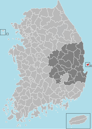
South Korea is made up of 22 first-tier administrative divisions: 6 metropolitan cities, 1 special city, 1 special self-governing city, and 14 provinces, including three special self-governing provinces and five claimed by the ROK government. These are further subdivided into a variety of smaller entities, including cities, counties, districts, towns, townships, neighborhoods and villages.

Gwangmyeong is a city in Gyeonggi Province, South Korea. It borders Seoul to the east, north and northeast, Anyang to the southeast, Siheung to the southwest, and Bucheon to the northeast.

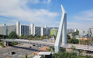
Namyangju is a city in Gyeonggi Province, South Korea. To the east is Gapyeong County, to the west is Guri City, and to the north is Pocheon City. Namyangju-si was originally a southern part of Yangju-gun, but was separated into Namyangju-gun in April 1980. In 1995, Migeum-si and Namyangju-gun were merged to form an urban and rural complex. The city hall is located in Geumgok-dong and Dasan-dong, and the administrative districts are 6-eup, 3-myeon, and 7-dong.

Pocheon (Korean pronunciation:[pʰo.tɕʰʌn]) is an inland city in the far northeastern region of Gyeonggi province in South Korea. It covers 826.48 km (513.55 mi)2 with a population of 160,176 people, according to the 2008 census. Pocheon lies between Seoul and the mountainous northwestern areas of Gangwon province. The city borders Yeoncheon county, with the cities of Dongducheon and Yangju to the west, along with Uijeongbu, and Namyangju of Gyeonggi province to the south. It also borders Hwacheon county of Gangwon province on its eastern border and Cheorwon is to the north. Alongside the adjoining Gapyeong, Pocheon consists of the highest mountainous areas in Gyeonggi province. The current city of Pocheon was created after Pocheon-hyeon and Yeongpyeong counties were merged. The north part of the city used to be part of Yeongpyeong county while the south used to be part of Pocheon-hyeon.

Mungyeong is a city in North Gyeongsang Province, South Korea. The local government, economy, and transportation networks are all centered in Jeomchon, the principal town. Mungyeong has a lengthy history, and is known today for its various historic and scenic tourist attractions. The city's name means roughly "hearing good news." Recently, development has been somewhat stagnant with the decline of the coal industry. Since the 1990s, the proportion of people who rely on the tourism industry through Mungyeong Saejae has gradually increased.
Ulleung County is a county in North Gyeongsang Province, South Korea.

Yeongdeungpo District is an administrative district in southwest Seoul, South Korea. Although the origin of the name is uncertain, the first two syllables are thought to be from "yeongdeung" (靈登) or "divine ascent", a shamanic rite. The third syllable is "po", representing the bank of a river (浦), referring to the district's position on the Han River. The 2006 population was 408,819.

Bangbae-dong is a dong, or neighbourhood of the greater Gangnam area Seocho District district of the South Korean city of Seoul. Bangbae-dong is divided into 5 different dongs which are Bangbaebon-dong, Bangbae 1-dong, 2-dong, 3-dong and 4-dong. The origin of Bangbae-dong is derived from the name Bangbae, meaning "dong-ri with my back to Mt. Myeon-ri," which rises on the border between Gwanak District and Seocho District. Bangbae-dong was Bangbae-ri, Sangbuk-myeon, Gwacheon-gun, Gyeonggi-do until the end of the Joseon Dynasty, but became Bangbae-ri, Sindong-myeon, Siheung-gun, Gyeonggi-do in 1914 when the area was confirmed during the Japanese colonial period. It was incorporated into the Seoul Metropolitan Government following the expansion of the Seoul Metropolitan Government's zone in 1963, and became Bangbae-dong to this day. The location is Dong at the western end of Seocho District, and it is an area from the intersection of the road from Seoul to Gwacheon City and the southern circulation road to Umyeon Mountain.

Bupyeong District is one of the 10 administrative divisions that comprise Incheon, South Korea. Bupyeong District comprises an area of 12.35 square miles, and has a population of 508,587. It is located north of Namdong District, east of Seo District, and south of Gyeyang District. The city of Bucheon, in neighboring Gyeonggi Province, comprises its eastern limit.

Bangi-dong (Korean: 방이동) is a neighborhood, dong of Songpa District, Seoul, South Korea.

Dangsan-dong is a dong (neighborhood) of Yeongdeungpo District, Seoul, South Korea.
Singil-dong is a dong, neighbourhood of Yeongdeungpo-gu in Seoul, South Korea.
Daerim-dong is a dong (neighborhood) of Yeongdeungpo District, Seoul, South Korea.
Yangpyeong-dong is a dong, neighborhood of Yeongdeungpo-gu in Seoul, South Korea.

Bogwang-dong is a dong (neighborhood) of Yongsan District in Seoul, South Korea.
Jugyo-dong is a legal dong, or neighbourhood of the Jung-gu district in Seoul, South Korea. It is governed by its administrative dong, Euljiro 3, 4, 5ga-dong.

Ulju County is a county occupying much of western Ulsan, South Korea.

Nam-gu is a non-autonomous district in the City of Pohang in North Gyeongsang Province, South Korea. Its name literally means "South District" as it is one of two districts in the city, the other being Buk-gu or "North District".
