Dorothy was initially established as a railroad station in 1916–17, after the Northern Pacific Railway extended its line from Tilden Junction to Winnipeg and built a spur through Red Lake Falls. The new town sucked away what was left of the historic river crossing town, Huot, and for a time sputtered toward prosperity, boasting a grain elevator, a Catholic church, a school and several houses.
The post office in Dorothy was first established February 11, 1898, with Joseph H. Mathews as postmaster. It was finally discontinued in 1945.[3]
The Federal Writers' Project reported in 1938 that the town had a population of 25, and "a beautiful church with stained-glass windows". In 1973, the railroad was abandoned and the grain elevator closed, and with it, the town's reason for existence was gone. By 2007, the church had been abandoned and appeared to be in use as a residence.
On October 24, 2014, the old church caught fire and burned to the ground in a conflagration that apparently started after embers from a pile of leaves a property owner was burning nearby blew towards the building, igniting the structure, which was a total loss.
Lake Crystal is a city in Blue Earth County, Minnesota, United States, established in 1869. The population was 2,539 at the 2020 census. It is part of the Mankato-North Mankato Metropolitan Statistical Area.
Badger Township is a township in Polk County, Minnesota, United States. It is part of the Grand Forks-ND-MN Metropolitan Statistical Area. Under the United States Public Land Survey System it is a survey township identified as Township 149 North, Range 42 West, Fifth Principal Meridian. The population was 166 at the 2000 census.
Erskine is a city in Polk County, Minnesota. The population was 403 at the time of the 2020 census. It is part of the Greater Grand Forks region.
Tenney is an unincorporated community and former city in section 28 of Campbell Township, Wilkin County, Minnesota, United States. A post office was established there in 1887, and Tenney was incorporated as a city on November 30, 1901. The population was five at the 2010 census, tying Tenney with Funkley as Minnesota's least populous community. It is part of the Wahpeton, ND–MN Micropolitan Statistical Area. The only portion of Tenney that is still active is a grain elevator along the tracks on the south side of town.
Hastings is a city mostly in Dakota County, Minnesota, of which it is the county seat, with a portion in Washington County, Minnesota, United States. It is near the confluence of the Mississippi, Vermillion, and St. Croix Rivers. The population was 22,154 at the 2020 census. It is named for the first elected governor of Minnesota, Henry Hastings Sibley.
Cisco is a place name for the remnants of a former unincorporated community located along the Soo Line Railroad and US 59 in the northwestern quarter of Section 11 of Badger Township, 149 North, Range 42 West, in Polk County, Minnesota, United States, approximately four miles north of the city of Erskine, and about the same distance south of the city of Brooks.
Huot is an unincorporated community in Louisville Township, Red Lake County, Minnesota, United States. The name of the community evokes the French-Canadian and Métis history of the Red River Trails and the Pembina settlements of Assiniboia.
Riverside is a small unincorporated community on the border of Davis Township and Logan Township in Fountain County, Indiana, United States.
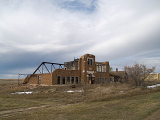
Wheelock is a ghost town in Wheelock Township, Williams County, in the northwestern part of the U.S. state of North Dakota. In 1938, the Federal Writers' Project found a population of 115 in Wheelock. In the 1990 census, the population was 23. All census population figures after 1990 are estimates. The town was disincorporated in 1994.
Winnipeg Junction is a ghost town in section 22 of Highland Grove Township in Clay County, Minnesota United States.
Soudan is an unincorporated community and census-designated place (CDP) in Breitung Township, Saint Louis County, Minnesota, United States. As of the 2020 census, its population was 385.
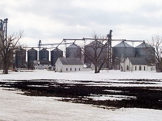
Radium is an unincorporated community in section 19 of Comstock Township, Marshall County, Minnesota, United States. It was built alongside the Minneapolis, St. Paul and Sault Ste. Marie Railroad branch line built in 1905 from Thief River Falls, Minnesota, to Kenmare, North Dakota. The place was named for the element radium. Radium had its own post office from 1905 to 1984. Since 1984, Radium has been served by the post office in Warren. It is also on the Warren telephone exchange and part of the Warren-Alvarado-Oslo school district. The townsite is being slowly reclaimed for use as farmland. There is still a large grain elevator on the railroad line south of the townsite. A small Lutheran church 1+1⁄2 miles (2.4 km) south of the town antedates the coming of the railroad; Immanuel Lutheran Church (LCMS) was organized in 1897.
Blackstone is an unincorporated village in section 7 of Sunbury Township, Livingston County, Illinois, United States. Blackstone is 10 miles (16 km) southeast of Streator and 13 miles (21 km) west of Dwight, Illinois. Blackstone has a post office with ZIP code 61313, a grainery complex, and a small rubber-products plant
Org is an unincorporated community in Nobles County, Minnesota, United States.
Reading is an unincorporated community in Nobles County, Minnesota, United States.
Delft is an unincorporated community located in Carson Township, Cottonwood County, Minnesota, United States.
Berea is an unincorporated community and census-designated place in Box Butte County, in the northwestern part of the state of Nebraska in the Midwestern United States. It had a population of 41 at the 2010 census.
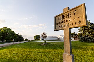
Cheney is an unincorporated community in Lancaster County, Nebraska, United States.
Blalock was an unincorporated community located in the Columbia River Gorge in Gilliam County, Oregon, United States. The town displaced a Native American settlement originally named Táwash. Blalock was located about 7 miles (11 km) west of Arlington on Interstate 84/U.S. Route 30 at the mouth of Blalock Canyon. Blalock is still the name of a station on the Union Pacific Railroad.
Gorman is an unincorporated community in Potter County, in the U.S. state of South Dakota.
This page is based on this Wikipedia article Text is available under the CC BY-SA 4.0 license; additional terms may apply. Images, videos and audio are available under their respective licenses.