Dover-Foxcroft (CDP), Maine

Last updated

Dover-Foxcroft, Maine
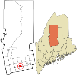
Piscataquis County Maine incorporated and unincorporated areas Dover-Foxcroft (CDP) highlighted.svg
Location in Piscataquis County and the state of Maine.
Coordinates: 45°11′11″N69°13′45″W / 45.18639°N 69.22917°W / 45.18639; -69.22917
CountryUnited States
State Maine
County Piscataquis
Area
[1]
  Total
8.61 sq mi (22.30 km2)
  Land8.38 sq mi (21.71 km2)
  Water0.23 sq mi (0.59 km2)
Elevation
361 ft (110 m)
Population
 (2020)
  Total
2,776
  Density331.23/sq mi (127.89/km2)
Time zone UTC-5 (Eastern (EST))
  Summer (DST) UTC-4 (EDT)
ZIP code
04426
Area code 207
FIPS code 23-18230
GNIS feature ID0565250

Dover-Foxcroft is a census-designated place (CDP) in the town of Dover-Foxcroft in Piscataquis County, Maine, United States. The population was 2,592 at the 2000 census.

Contents

Geography

Dover-Foxcroft is located at 45°11′10″N69°13′45″W / 45.18611°N 69.22917°W / 45.18611; -69.22917 (45.186372, −69.229193). [2]

According to the United States Census Bureau, the CDP has a total area of 8.6 square miles (22.3 km2), of which 8.4 square miles (21.8 km2) is land and 0.2 square mile (0.5 km2) (2.21%) is water.

Demographics

Historical population
CensusPop.Note
2020 2,776
U.S. Decennial Census [3]

As of the census [4] of 2000, there were 2,592 people, 1,091 households, and 710 families residing in the CDP. The population density was 307.8 inhabitants per square mile (118.8/km2). There were 1,256 housing units at an average density of 149.1 per square mile (57.6/km2). The racial makeup of the CDP was 96.41% White, 0.19% Black or African American, 0.42% Native American, 0.81% Asian, 0.04% Pacific Islander, 0.19% from other races, and 1.93% from two or more races. Hispanic or Latino of any race were 1.12% of the population.

There were 1,091 households, out of which 29.7% had children under the age of 18 living with them, 48.9% were married couples living together, 11.8% had a female householder with no husband present, and 34.9% were non-families. 29.5% of all households were made up of individuals, and 14.4% had someone living alone who was 65 years of age or older. The average household size was 2.32 and the average family size was 2.83.

In the CDP, the population was spread out, with 23.9% under the age of 18, 6.4% from 18 to 24, 26.3% from 25 to 44, 25.2% from 45 to 64, and 18.3% who were 65 years of age or older. The median age was 41 years. For every 100 females, there were 88.0 males. For every 100 females age 18 and over, there were 85.1 males.

The median income for a household in the CDP was $28,929, and the median income for a family was $39,554. Males had a median income of $28,315 versus $21,641 for females. The per capita income for the CDP was $16,692. About 9.5% of families and 13.4% of the population were below the poverty line, including 22.8% of those under age 18 and 4.6% of those age 65 or over.

Related Research Articles

Willow Creek is a census-designated place (CDP) in Copper River Census Area, Alaska, United States. At the 2020 census the population was 190, down from 191 in 2010.

<span class="mw-page-title-main">Highland Acres, Delaware</span> CDP in Delaware, United States

Highland Acres is a census-designated place (CDP) in Kent County, Delaware, United States. It is part of the Dover, Delaware Metropolitan Statistical Area. The population was 3,459 at the 2010 census.

<span class="mw-page-title-main">Riverview, Delaware</span> CDP in Delaware, United States

Riverview is a census-designated place (CDP) in Kent County, Delaware, United States. It is part of the Dover, Delaware Metropolitan Statistical Area. The population was 2,456 at the 2010 census.

<span class="mw-page-title-main">Nokomis, Florida</span> Census-designated place in Florida, United States

Nokomis is an unincorporated town in Sarasota County and a census-designated place (CDP) along the Gulf Coast of Florida, United States, located south of Osprey and just north of Venice. The town has access to the coast through Nokomis Public Beach and Casey Key. The town's population was 3,217 at the 2020 census, up from 3,167 at the 2010 census. It is part of the North Port–Bradenton–Sarasota, Florida Metropolitan Statistical Area.

<span class="mw-page-title-main">Reed Plantation, Maine</span> Plantation in Maine, United States

Reed Plantation is a plantation in Aroostook County, Maine, United States. The population was 129 at the 2020 census.

<span class="mw-page-title-main">Edgemere, Maryland</span> Census-designated place in Maryland, United States

Edgemere is an unincorporated community and census-designated place in Baltimore County, Maryland, United States. The population was 8,669 at the 2010 census. Founded in 1899 as Edgemere being renamed from previous name "Fitzell". Meeting held at the Fitzell Farm which was situated where the old Rheem plant was located.

<span class="mw-page-title-main">Laurel Lake, New Jersey</span> Populated place in Cumberland County, New Jersey, US

Laurel Lake is an unincorporated community and census-designated place (CDP) located within Commercial Township, in Cumberland County, in the U.S. state of New Jersey. It is part of the Vineland-Millville-Bridgeton Primary Metropolitan Statistical Area for statistical purposes. As of the 2010 United States Census, the CDP's population was 2,989.

Horseheads North is a census-designated place (CDP) in Chemung County, New York, United States. It is part of the Elmira Metropolitan Statistical Area. As of the 2010 census, the population of the CDP was 2,843.

<span class="mw-page-title-main">Waller, Pennsylvania</span> Census-designated place in Pennsylvania, United States

Waller is a census-designated place (CDP) in Columbia County, Pennsylvania, United States. It is part of the Bloomsburg–Berwick micropolitan area in Northeastern Pennsylvania. The population was 45 at the 2020 census.

Lower Allen is a census-designated place (CDP) in Lower Allen Township in Cumberland County, Pennsylvania, United States. The population was 6,694 at the 2010 census. It is part of the Harrisburg–Carlisle metropolitan statistical area.

<span class="mw-page-title-main">Colonial Park, Pennsylvania</span> Census-designated place in Pennsylvania, United States

Colonial Park is an unincorporated community and census-designated place (CDP) in Lower Paxton Township, Pennsylvania, United States. The population was 13,229 at the 2010 census. It is part of the Harrisburg–Carlisle Metropolitan Statistical Area. It uses the Harrisburg ZIP code of 17109 and hosts a great deal of the area's retail activity, including the Colonial Park Mall.

<span class="mw-page-title-main">Gastonville, Pennsylvania</span> Census-designated place in Pennsylvania, United States

Gastonville is a census-designated place (CDP) in Washington County, Pennsylvania, United States. The population was 2,818 at the 2010 census.

<span class="mw-page-title-main">Union Hall, Virginia</span> CDP in Virginia, United States

Union Hall is a census-designated place (CDP) in Franklin County, Virginia, United States. The population estimate was approximately 1,091 according to a census in 2018. It is part of the Roanoke Metropolitan Statistical Area.

<span class="mw-page-title-main">Salisbury (CDP), Massachusetts</span> Census-designated place in Massachusetts, United States

Salisbury is a census-designated place (CDP) in the town of Salisbury in Essex County, Massachusetts, United States. The population was 4,869 at the 2010 census.

Dexter is a census-designated place (CDP) comprising the main settlement within the town of Dexter in Penobscot County, Maine, United States. The population of the CDP was 2,158 at the 2010 census.

Newport is a census-designated place (CDP) consisting of the main area of settlement within the town of Newport in Penobscot County, Maine, United States. The population of the CDP was 1,776 at the 2010 census.

<span class="mw-page-title-main">Dover-Foxcroft, Maine</span> Town in Maine, United States

Dover-Foxcroft is the largest town in and the seat of Piscataquis County, Maine, United States. The population was 4,422 at the 2020 census. The town is located near the geographic center of the state.

<span class="mw-page-title-main">Guilford (CDP), Maine</span> Census-designated place in Maine, United States

Guilford is a census-designated place (CDP) in the town of Guilford in Piscataquis County, Maine, United States. The population was 945 at the 2000 census.

Bingham is a census-designated place (CDP) in the town of Bingham in Somerset County, Maine, United States. The population was 856 at the 2000 census.

<span class="mw-page-title-main">Skowhegan (CDP), Maine</span> CDP in Maine, United States

Skowhegan is a census-designated place (CDP) in the town of Skowhegan in Somerset County, Maine, United States. The population was 6,404 at the 2020 census.
References

  1. "2020 U.S. Gazetteer Files". United States Census Bureau. Retrieved April 8, 2022.
  2. "US Gazetteer files: 2010, 2000, and 1990". United States Census Bureau. February 12, 2011. Retrieved April 23, 2011.
  3. "Census of Population and Housing". Census.gov. Retrieved June 4, 2016.
  4. "U.S. Census website". United States Census Bureau . Retrieved 2008-01-31.