Northeast Piscataquis, Maine

Last updated
Northeast Piscataquis, Maine
Northeast Piscataquis, ME, USA - panoramio.jpg
Piscataquis County Maine incorporated and unincorporated areas Northeast Piscataquis highlighted.svg
Location in Piscataquis County and the state of Maine.
Coordinates: 45°54′37″N69°05′13″W / 45.91028°N 69.08694°W / 45.91028; -69.08694
Country United States
State Maine
County Piscataquis
Area
  Total1,820.4 sq mi (4,714.8 km2)
  Land1,710.5 sq mi (4,430.3 km2)
  Water109.8 sq mi (284.5 km2)
Elevation
1,404 ft (428 m)
Population
 (2020)
  Total304
  Density0.17/sq mi (0.064/km2)
Time zone UTC-5 (Eastern (EST))
  Summer (DST) UTC-4 (EDT)
ZIP code
04462
Area code 207
FIPS code 23-51105
GNIS feature ID582629

Northeast Piscataquis is an unincorporated area in Piscataquis County, Maine, United States. The population was 304 at the 2020 census. [1]

Contents

Geography

According to the United States Census Bureau, the unorganized territory has a total area of 1,820.4 square miles (4,714.8 km2), of which 1,710.5 square miles (4,430.3 km2) is land and 109.8 square miles (284.5 km2) (6.03%) is water.

The territory contains 42 townships plus parts of ten other townships (shared with Northwest Piscataquis).

Baxter State Park, the location of Mount Katahdin, Maine's highest mountain, is located within the territory.

Demographics

Historical population
CensusPop.Note
1980 132
1990 21865.2%
2000 34759.2%
2010 273−21.3%
2020 30411.4%
U.S. Decennial Census [2]

As of the census [3] of 2000, there were 347 people, 157 households, and 108 families residing in the unorganized territory. The population density was 0.2 inhabitants per square mile (0.077/km2). There were 1,214 housing units at an average density of 0.7 per square mile (0.27/km2). The racial makeup of the unorganized territory was 99.14% White, 0.29% Native American, 0.29% Asian, and 0.29% from two or more races.

There were 157 households, out of which 21.7% had children under the age of 18 living with them, 63.7% were married couples living together, 1.9% had a female householder with no husband present, and 31.2% were non-families. 27.4% of all households were made up of individuals, and 8.9% had someone living alone who was 65 years of age or older. The average household size was 2.21 and the average family size was 2.62.

In the unorganized territory the population was spread out, with 20.5% under the age of 18, 3.5% from 18 to 24, 22.8% from 25 to 44, 41.8% from 45 to 64, and 11.5% who were 65 years of age or older. The median age was 46 years. For every 100 females, there were 109.0 males. For every 100 females age 18 and over, there were 115.6 males.

The median income for a household in the unorganized territory was $31,250, and the median income for a family was $37,813. Males had a median income of $31,364 versus $16,250 for females. The per capita income for the unorganized territory was $15,643. About 7.7% of families and 10.9% of the population were below the poverty line, including 14.3% of those under age 18 and 7.7% of those age 65 or over.

Williamsburg

The town of Williamsburg was dissolved and incorporated into Northeast Piscataquis in 1940. Williamsburg was located in the southern part of Piscataquis County, 17 miles north-east of Dover-Foxcroft. It was located to the west of Brownville. The West Branch of the Pleasant River ran through the town. It was the hometown of Lieutenant Colonel Walter Goodale Morrill. The area was first settled by people of European descent during the first decades of the 19th century and was incorporated as a town in 1820. In 1870, the town's population was 176, but the town grew to 444 residents for the 1880 census. [4] The 1900 census showed that Williamsburg had a population of 117, the smallest of all incorporated towns in the county. In 1910, it had a population of 138, the second smallest population of any incorporated place in the county. In 1920, the population dropped to 82 residents and in 1930, the final census as a separate town, Williamsburg's population was 67 people.

Related Research Articles

<span class="mw-page-title-main">Piscataquis County, Maine</span> County in Maine, United States

Piscataquis County is a county located in the U.S. state of Maine. As of the 2020 census, its population was 16,800, making it Maine's least-populous county. Its county seat is Dover-Foxcroft. The county was incorporated on March 23, 1838, taken from the western part of Penobscot County and the eastern part of Somerset County. It is named for an Abenaki word meaning "branch of the river" or "at the river branch."

<span class="mw-page-title-main">Atkinson, Maine</span> Township in Maine, United States

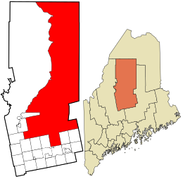
Atkinson is an unincorporated township and former town in Piscataquis County, Maine, United States, and part of the state's Unorganized Territory. Its population was 326 at the 2010 census.

<span class="mw-page-title-main">Medford, Maine</span> Town in the state of Maine, United States

Medford is a town in Piscataquis County, Maine, United States. The population was 230 at the 2020 census.

<span class="mw-page-title-main">Central Aroostook, Maine</span> Unorganized territory in Maine, United States

Central Aroostook is an unorganized territory in Aroostook County, Maine, United States. The population was 164 at the 2020 census.

<span class="mw-page-title-main">Northwest Aroostook, Maine</span> Unorganized territory in Maine, United States

Northwest Aroostook is an unorganized territory in Aroostook County, Maine, United States. The population was 12 at the 2020 census.

<span class="mw-page-title-main">South Aroostook, Maine</span> Unorganized territory in Maine, United States

South Aroostook is an unorganized territory in Aroostook County, Maine, United States. The population was 579 at the 2020 census.

<span class="mw-page-title-main">Square Lake, Maine</span> Unorganized territory in Maine, United States

Square Lake is an unorganized territory in Aroostook County, Maine, United States. The population was 706 at the 2020 census.

<span class="mw-page-title-main">East Central Franklin, Maine</span> Unorganized territory in Maine, United States

East Central Franklin is an unorganized territory in Franklin County, Maine, United States. The population was 805 at the 2020 census.

North Franklin is an unorganized territory in Franklin County, Maine, United States. The population was 41 at the 2020 census. The territory consists of 13 townships and three gores, namely Lang, Davis, Tim Pond, Stetsontown, Jim Pond, Alder Stream, Seven Ponds, Kibby, Chain of Ponds, Massachusetts Gore, Coburn Gore, Skinner, Merrill Strip, Lowelltown, Gorham Gore, and Beattie.

Central Hancock, also known as Fletchers Landing, is an unorganized territory (township) in Hancock County, Maine, United States. The population was 132 at the 2020 census. The territory is designated as Township 8 Southern Division.

<span class="mw-page-title-main">South Oxford, Maine</span> Unorganized territory in Maine, United States

South Oxford is an unorganized territory located in Oxford County, Maine, United States. The population was 591 at the 2020 census. The unorganized territory encompasses the areas designated under state law as Albany Township, Mason Township, and Batchelder's Grant. Albany and Mason were formerly incorporated as towns. Albany disincorporated in 1937 while Mason disincorporated in 1935.

Argyle is an unorganized territory (township) in Penobscot County, Maine, United States. The population was 255 at the 2020 census.

Kingman is an unorganized territory (township) in Penobscot County, Maine, United States. The population was 137 at the 2020 census.

Prentiss is an unorganized territory (township) in Penobscot County, Maine, United States. The township was named for Henry Prentiss, an early landowner. The population was 169 at the 2020 census.

<span class="mw-page-title-main">Blanchard, Maine</span> Unorganized territory in Maine, United States

Blanchard is an unorganized territory (township) in Piscataquis County, Maine, United States. The population was 91 at the 2020 census.

<span class="mw-page-title-main">Northwest Piscataquis, Maine</span> Unorganized territory in Maine, United States

Northwest Piscataquis is an unincorporated area in Piscataquis County, Maine, United States. The population was 134 at the 2020 census.

<span class="mw-page-title-main">Southeast Piscataquis, Maine</span> Unorganized territory in Maine, United States

Southeast Piscataquis, also known as Orneville, is an unincorporated area (township) in Piscataquis County, Maine, United States. The population was 487 at the 2020 census.

East Central Washington is an unorganized territory in Washington County, Maine, United States. The population was 724 at the 2020 census.

North Washington is an unorganized territory in Washington County, Maine, United States. The population was 505 at the 2020 census.

<span class="mw-page-title-main">Guilford, Maine</span> Town in the state of Maine, United States

Guilford is a town in Piscataquis County, Maine, United States. The town is located on the Piscataquis River and was first settled in 1806. The population was 1,267 at the time of the 2020 census.

References

  1. "Census - Geography Profile: Northeast Piscataquis UT, Piscataquis County, Maine" . Retrieved March 20, 2022.
  2. "Census of Population and Housing". Census.gov. Retrieved June 4, 2015.
  3. "U.S. Census website". United States Census Bureau . Retrieved 2008-01-31.
  4. History of Williamsburg, Maine A Gazetteer of the State of Maine, 1886