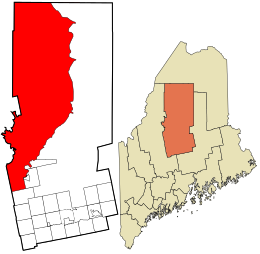
Piscataquis County is a county located in the U.S. state of Maine. As of the 2020 census, its population was 16,800, making it Maine's least-populous county. Its county seat is Dover-Foxcroft. The county was incorporated on March 23, 1838, taken from the western part of Penobscot County and the eastern part of Somerset County. It is named for an Abenaki word meaning "branch of the river" or "at the river branch."

Atkinson is an unincorporated township and former town in Piscataquis County, Maine, United States, and part of the unorganized territory of Southeast Piscataquis, Maine. Its population was 326 at the 2010 census.

Connor is an unorganized territory (township) in Aroostook County, Maine, United States. The population was 418 at the 2020 census. It is the location of a former Nike missile site and the Blotner Radar Site.

Northwest Aroostook is an unorganized territory in Aroostook County, Maine, United States. The population was 12 at the 2020 census.

Square Lake is an unorganized territory in Aroostook County, Maine, United States. The population was 706 at the 2020 census.

East Central Franklin is an unorganized territory in Franklin County, Maine, United States. The population was 805 at the 2020 census.
South Franklin is an unorganized territory in Franklin County, Maine, United States. The population was 60 at the 2020 census.
Central Hancock, also known as Fletchers Landing, is an unorganized territory (township) in Hancock County, Maine, United States. The population was 132 at the 2020 census. The territory is designated as Township 8 Southern Division.
East Hancock is an unorganized territory in Hancock County, Maine, United States. The population was 85 at the 2020 census.
Kingman is an unorganized territory (township) in Penobscot County, Maine, United States. The population was 137 at the 2020 census.
North Penobscot is an unorganized territory in Penobscot County, Maine, United States. The population was 405 at the 2020 census.
Prentiss is an unorganized territory (township) in Penobscot County, Maine, United States. The township was named for Henry Prentiss, an early landowner. The population was 169 at the 2020 census.

Blanchard is an unorganized territory (township) in Piscataquis County, Maine, United States. The population was 91 at the 2020 census.

Northeast Piscataquis is an unincorporated area in Piscataquis County, Maine, United States. The population was 304 at the 2020 census.

Southeast Piscataquis is an unincorporated area in Piscataquis County, Maine, United States. It comprises Orneville Township, and, since 2019, Atkinson Township. The population was 487 at the 2020 census.
East Central Washington is an unorganized territory in Washington County, Maine, United States. The population was 724 at the 2020 census.
Lake No. 2 is an unorganized territory in Lake County, Minnesota, United States. The population was 1,955 at the 2000 census.
Mud Hen Lake is an unorganized territory in Saint Louis County, Minnesota, United States. The population was 320 at the 2000 census.
Whiteface Reservoir is an unorganized territory in Saint Louis County, Minnesota, United States. The population was 292 at the 2000 census.

Unity is an unincorporated territory (township) in Kennebec County, Maine, United States. The population was 36 at the 2020 census. The township was a former plantation that surrendered its organization in 1942.