Franconia is a region of Germany, characterised by its culture and Franconian dialect. While several Germanic dialects are referred to as Franconian, only the East Franconian dialects are also colloquially referred to as "Franconian", and only the East Franconian dialect area is regarded as Franconia.

The Main is the longest tributary of the Rhine. It rises as the White Main in the Fichtel Mountains of northeastern Bavaria and flows west through central Germany for 525 kilometres (326 mi) to meet the Rhine below Rüsselsheim, Hesse. The cities of Mainz and Wiesbaden are close to the confluence.

Lower Franconia is one of seven districts of Bavaria, Germany. The districts of Lower, Middle and Upper Franconia make up the region of Franconia. It consists of nine districts and 308 municipalities.

Upper Franconia is a Regierungsbezirk of the state of Bavaria, southern Germany. It forms part of the historically significant region of Franconia, the others being Middle Franconia and Lower Franconia, which are all now part of the German Federal State of Bayern (Bavaria).

Middle Franconia is one of the three administrative regions of Franconia in Bavaria, Germany. It is located in the west of Bavaria and borders the state of Baden-Württemberg. The administrative seat is Ansbach; however, the most populous city is Nuremberg.

The Franconian Circle was an Imperial Circle established in 1500 in the centre of the Holy Roman Empire. It comprised the eastern part of the former Franconian stem duchy—roughly corresponding with the present-day Bavarian Regierungsbezirke of Upper, Middle and Lower Franconia—while western Rhenish Franconia belonged to the Upper Rhenish Circle. The title of a "Duke of Franconia" was claimed by the Würzburg bishops.

Southern Germany is a region of Germany that included the areas in which Upper German dialects are spoken, which includes the stem duchies of Bavaria and Swabia.

Altbayern is the territory and people of the three oldest parts of the Free State of Bavaria, which were earlier known as Kurbayern after the former Electorate of Bavaria.

Franconian or Frankish is a collective term traditionally used by linguists to refer to many West Germanic languages, some of which are spoken in what formed the historical core area of Francia during the Early Middle Ages. Linguistically, there are no typological features that are typical for all the various dialects conventionally grouped as Franconian. As such, it forms a residual category within the larger historical West Germanic dialect continuum rather than a homogeneous group of closely related dialects. For most of the varieties grouped under the term "Franconian", the diachronical connection to the Frankish language, which was spoken by the Franks, is unclear.

This division of Germany into major natural regions takes account primarily of geomorphological, geological, hydrological, and pedological criteria in order to divide the country into large, physical units with a common geographical basis. Political boundaries play no part in this, apart from defining the national border.

The Rennsteig is a ridge walk as well as an historical boundary path in the Thuringian Forest, Thuringian Highland and Franconian Forest in Central Germany. The long-distance trail runs for about 170 km from Eisenach and the Werra valley in the northwest to Blankenstein and the Selbitz river in the southeast.

Erlach is a small village located in Bavaria, Germany. It is in Upper Franconia, in the Bamberg district. Erlach is a constituent community of Hirschaid.

On 8 March 1988 the Bavarian State Ministry for State Development and the Environment designated an area of 1,280 square kilometres (490 sq mi) in the Steigerwald in North Bavaria, Germany, as the Steigerwald Nature Park. About half the area consists of protected landscapes. The nature park is run by the Steigerwald Tourist Association and Steigerwald Nature Park.

The Steigerwald is a hill region up to 498.5 m above sea level (NHN) in the Bavarian-Franconian part of the South German Scarplands between Würzburg and Nuremberg. It is part of the Keuper Uplands, and within it, it is continued to the north-northeast and right of the river Main, by the Haßberge, and to the south-southwest by the Franconian Heights. Part of the region is a designated as the Steigerwald Nature Park.
The Hassberge Formation is a geologic formation in Bavaria, Germany. It preserves fossils dating back to the Carnian stage of the Triassic period.
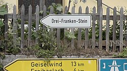
Kleinbirkach is a village located in Upper Franconia, Bavaria, Germany, and is a part of the town of Ebrach. It is most well known for its proximity to the Dreifrankenstein. Its current population is 29.

The Franconian Rake is the name given to the coat of arms of the region of Franconia in Germany. It is described heraldically as per fess dancetty of three points gules and argent. The points represent a stylised heraldic rake.
The Franconian Heights are a hill ridge, up to 554 m above sea level (NN), in Bavaria and Baden-Württemberg in South Germany.

Franconia Day or Tag der Franken was born in 2006 following a decision by the Bavarian Landtag and has been celebrated annually since then on 2 July or on the weekend immediately following. It is intended to highlight the diverse landscape and history of the Franconian region and to raise awareness of Franconia's potential for development and innovation. The central festive event is held alternately in and by the three Franconian provinces in Bavaria - Upper Franconia, Middle Franconia and Lower Franconia - and has the character of a state festival day.