Related Research Articles

Hydrology is the scientific study of the movement, distribution, and management of water on Earth and other planets, including the water cycle, water resources, and drainage basin sustainability. A practitioner of hydrology is called a hydrologist. Hydrologists are scientists studying earth or environmental science, civil or environmental engineering, and physical geography. Using various analytical methods and scientific techniques, they collect and analyze data to help solve water related problems such as environmental preservation, natural disasters, and water management.

A general circulation model (GCM) is a type of climate model. It employs a mathematical model of the general circulation of a planetary atmosphere or ocean. It uses the Navier–Stokes equations on a rotating sphere with thermodynamic terms for various energy sources. These equations are the basis for computer programs used to simulate the Earth's atmosphere or oceans. Atmospheric and oceanic GCMs are key components along with sea ice and land-surface components.
The Palmer drought index, sometimes called the Palmer drought severity index (PDSI), is a regional drought index commonly used for monitoring drought events and studying areal extent and severity of drought episodes. The index uses precipitation and temperature data to study moisture supply and demand using a simple water balance model. It was developed by meteorologist Wayne Palmer, who first published his method in the 1965 paper Meteorological Drought for the Office of Climatology of the U.S. Weather Bureau.
Desert Research Institute (DRI) is the nonprofit research campus of the Nevada System of Higher Education (NSHE), the organization that oversees all publicly supported higher education in the U.S. state of Nevada. At DRI, approximately 460 research faculty and support staff engage in $43 million in sponsored research each year. DRI's environmental research programs are divided into three core divisions and a robust K-12 STEM education program. Established in 1988, the institute's Nevada Medal awards "outstanding achievement in science and engineering".
The Geophysical Fluid Dynamics Laboratory (GFDL) is a laboratory in the National Oceanic and Atmospheric Administration (NOAA) Office of Oceanic and Atmospheric Research (OAR). The current director is Dr. Venkatachalam Ramaswamy. It is one of seven NOAA Research Laboratories (RLs).
Numerical weather prediction (NWP) uses mathematical models of the atmosphere and oceans to predict the weather based on current weather conditions. Though first attempted in the 1920s, it was not until the advent of computer simulation in the 1950s that numerical weather predictions produced realistic results. A number of global and regional forecast models are run in different countries worldwide, using current weather observations relayed from radiosondes, weather satellites and other observing systems as inputs.
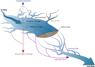
Ecohydrology is an interdisciplinary scientific field studying the interactions between water and ecological systems. It is considered a sub discipline of hydrology, with an ecological focus. These interactions may take place within water bodies, such as rivers and lakes, or on land, in forests, deserts, and other terrestrial ecosystems. Areas of research in ecohydrology include transpiration and plant water use, adaption of organisms to their water environment, influence of vegetation and benthic plants on stream flow and function, and feedbacks between ecological processes, the soil carbon sponge and the hydrological cycle.

This is a list of meteorology topics. The terms relate to meteorology, the interdisciplinary scientific study of the atmosphere that focuses on weather processes and forecasting.
An isoscape is a geologic map of isotope distribution. It is a spatially explicit prediction of elemental isotope ratios (δ) that is produced by executing process-level models of elemental isotope fractionation or distribution in a geographic information system (GIS).

An hydrological transport model is a mathematical model used to simulate the flow of rivers, streams, groundwater movement or drainage front displacement, and calculate water quality parameters. These models generally came into use in the 1960s and 1970s when demand for numerical forecasting of water quality and drainage was driven by environmental legislation, and at a similar time widespread access to significant computer power became available. Much of the original model development took place in the United States and United Kingdom, but today these models are refined and used worldwide.

Groundwater recharge or deep drainage or deep percolation is a hydrologic process, where water moves downward from surface water to groundwater. Recharge is the primary method through which water enters an aquifer. This process usually occurs in the vadose zone below plant roots and is often expressed as a flux to the water table surface. Groundwater recharge also encompasses water moving away from the water table farther into the saturated zone. Recharge occurs both naturally and through anthropogenic processes, where rainwater and or reclaimed water is routed to the subsurface.

A hydrologic model is a simplification of a real-world system that aids in understanding, predicting, and managing water resources. Both the flow and quality of water are commonly studied using hydrologic models.
The Global Energy and Water Exchanges Project is an international research project and a core project of the World Climate Research Programme (WCRP).

Soil Moisture Active Passive (SMAP) is a NASA environmental monitoring satellite that measures soil moisture across the planet. It is designed to collect a global 'snapshot' of soil moister every 2 to 3 days. With this frequency, changes from specific storms can be measured while also assessing impacts across seasons of the year. SMAP was launched on 31 January 2015. It was one of the first Earth observation satellites developed by NASA in response to the National Research Council's Decadal Survey.
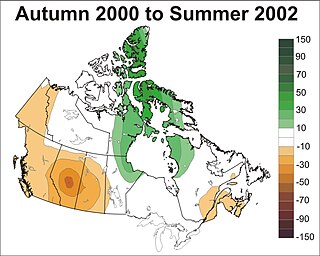
Prolonged, large-area droughts are among Canada's costliest natural disasters having major impacts on a wide range of sectors including agriculture, forestry, industry, municipalities, recreation, human health, society and ecosystems. They frequently stress water availability by depleting soil moisture, reducing stream flows, lowering lake and reservoir levels, and diminishing groundwater supplies. This ultimately affects several economic activities including for example, decreased agricultural production, less hydro-electric power generation, and increased freshwater transportation costs. Droughts also create major environmental hazards such as reduced water quality, wetland loss, soil erosion and degradation, and ecological habitat destruction.
The following outline is provided as an overview of and topical guide to hydrology:
DPHM-RS is a semi-distributed hydrologic model developed at University of Alberta, Canada.
The global freshwater model WaterGAP calculates flows and storages of water on all continents of the globe, taking into account the human influence on the natural freshwater system by water abstractions and dams. It supports understanding the freshwater situation across the world's river basins during the 20th and the 21st centuries, and is applied to assess water scarcity, droughts and floods and to quantify the impact of human actions on e.g. groundwater, wetlands, streamflow and sea-level rise. Modelling results of WaterGAP have contributed to international assessment of the global environmental situation including the UN World Water Development Reports, the Millennium Ecosystem Assessment, the UN Global Environmental Outlooks as well as to reports of the Intergovernmental Panel on Climate Change. WaterGAP contributes to the Intersectoral Impact Model Intercomparison Project ISIMIP, where consistent ensembles of model runs by a number of global hydrological models are generated to assess the impact of climate change and other anthropogenic stressors on freshwater resources world-wide.

A precipitationshed is the upwind ocean and land surface that contributes evaporation to a given, downwind location's precipitation. The concept has been described as an "atmospheric watershed". The concept itself rests on a broad foundation of scholarly work examining the evaporative sources of rainfall. Since its formal definition, the precipitationshed has become an element in water security studies, examinations of sustainability, and mentioned as a potentially useful tool for examining vulnerability of rainfall dependent ecosystems.
The effects of climate change on the water cycle are profound and have been described as an "intensification" or an overall "strengthening" of the water cycle. This effect has been observed since at least 1980. One example is the intensification of heavy precipitation events. This has important knock-on effects on the availability of freshwater resources, as well as other water reservoirs such as oceans, ice sheets, atmosphere and land surface. The water cycle is essential to life on earth and plays a large role in the global climate and the ocean circulation. The warming of the earth is expected to cause changes in the water cycle for various reasons. For example, warmer atmosphere can contain more water vapor which has effects on evaporation and rainfall. Oceans play a large role as well, since they absorb 93% of heat. The increase in ocean heat content since 1971 has a big effect on the ocean as well as the cycle. To avoid further, or more extreme, changes to the water cycle, greenhouse gas emissions must be reduced.
References
- 1 2 Stewart, R., J. Pomeroy, and R. Lawford, 2008: A Drought Research Initiative for the Canadian Prairies, CMOS Bulletin, Vol. 36, No. 3, 97-102.
- ↑ Phillips, D.W., 2002: The top ten Canadian weather stories for 2001. CMOS Bulletin, 30, 19-23.
- ↑ Statistics Canada, 2003: Net Farm Income. Catalogue No. 21-010-XIE, Volume 2. Ottawa, Ontario.
- ↑ Wheaton, E, Wittrock V, Kulshreshtha S, Koshida G, Grant C, Chipanshi A, Bonsal BR (2005) Lessons learned from the drought years of 2001 and 2002: synthesis report. Agriculture and Agri-Food Canada, Saskatchewan Research Council Publ No. 11602–46E03, Saskatoon
- ↑ Bonsal, B., 2008: Droughts in Canada: an overview. CMOS Bulletin, Vol. 36, No. 3, 79-86.
- ↑ Lawford, R., H. Hill, E. Wheaton, I. Hanuta, A. Warkentin, B. Girling, and R. Stewart, 2008: A review of some requirements for drought information on the Canadian Prairies. CMOS Bulletin, Vol. 36, No. 3, 97-102.