Dry Creek (Crooked Creek)

Last updated
Dry Creek
Country United States
State Oregon
County Malheur
Source
 - locationnear Five Points
 - elevation5,000 ft (1,524 m) [1]
 - coordinates 42°30′31″N117°17′44″W / 42.50861°N 117.29556°W / 42.50861; -117.29556   [2]
Mouth Crooked Creek
 - locationnear Burns Junction
 - elevation3,570 ft (1,088 m) [2]
 - coordinates 42°47′42″N117°44′47″W / 42.79500°N 117.74639°W / 42.79500; -117.74639 Coordinates: 42°47′42″N117°44′47″W / 42.79500°N 117.74639°W / 42.79500; -117.74639   [2]
Length54 mi (87 km) [3]
Basin299 sq mi (774 km2) [4]
USA Oregon location map.svg
Red pog.svg
Location of the mouth of Dry Creek in Oregon

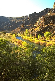
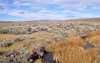
Dry Creek is a tributary, 54 miles (87 km) long, of Crooked Creek in the U.S. state of Oregon. [3] The creek, which is intermittent, begins in the desert near Five Points in Malheur County. [5] It joins Crooked Creek east of Burns Junction and about 7 miles (11 km) south of the larger stream's confluence with the Owyhee River. [6] Dry Creek drains a basin of about 299 square miles (770 km2). [4]

Crooked Creek (Oregon) river in the United States of America

Crooked Creek is a 51-mile (82 km) tributary of the Owyhee River in the U.S. state of Oregon. The source of Crooked Creek is at an elevation of 3,921 feet (1,195 m) at Crooked Creek Spring, while the mouth is at an elevation of 3,343 feet (1,019 m) near Rome. Crooked Creek has a 1,340-square-mile (3,500 km2) watershed.

Oregon State of the United States of America

Oregon is a state in the Pacific Northwest region on the West Coast of the United States. The Columbia River delineates much of Oregon's northern boundary with Washington, while the Snake River delineates much of its eastern boundary with Idaho. The parallel 42° north delineates the southern boundary with California and Nevada. Oregon is one of only three states of the contiguous United States to have a coastline on the Pacific Ocean.

Malheur County, Oregon County in the United States

Malheur County is a county in the southeast corner of the U.S. state of Oregon. As of the 2010 census, the population was 31,313. Its county seat is Vale, and its largest city is Ontario. The county was named after the Malheur River, which runs through the county. "Malheur" is French for misfortune or tragedy.

Forming northeast of Five Points, Dry Creek flows north, then west, across Squaw Flat in southern Malheur County near the border with the U.S. state of Nevada. Near Garlow Butte, Coyote Creek enters from the left, and near Caviatta Ridge, Peacock Creek enters from the left. West of Caviatta Ridge, the creek turns north and receives Corbin Creek from the right. Dry Creek flows through Blevins Reservoir and then Rockhouse Reservoir before turning west again and receiving Indian Fort Creek from the right. Turning north, it joins Crooked Creek just south of U.S. Route 95 about halfway between Burns Junction and Rome. [5] [6]

Nevada State of the United States of America

Nevada is a state in the Western United States. It is bordered by Oregon to the northwest, Idaho to the northeast, California to the west, Arizona to the southeast and Utah to the east. Nevada is the 7th most extensive, the 32nd most populous, but the 9th least densely populated of the U.S. states. Nearly three-quarters of Nevada's people live in Clark County, which contains the Las Vegas–Paradise metropolitan area where three of the state's four largest incorporated cities are located. Nevada's capital, however, is Carson City.

U.S. Route 95 highway in the United States

U.S. Route 95 (US 95) is a north–south U.S. highway in the western United States. Unlike many other US highways, it has not seen deletion or replacement on most of its length by an encroaching Interstate highway corridor, due to its mostly rural course. Because of this, it still travels from border to border and is a primary north–south highway in both Nevada and Idaho. This is one of the only US Routes or Interstate highways to cross from Mexico to Canada.

Rome, Oregon Unincorporated community in Oregon, United States

Rome, also called Rome Station after its sole business, is an unincorporated community in Malheur County, Oregon, United States. It is part of the Ontario, OR–ID Micropolitan Statistical Area. In the sparsely populated high desert of southeastern Oregon, Rome is immediately west of the Owyhee River on U.S. Route 95, approximately 12 miles (19 km) northeast of Burns Junction. Jordan Creek enters the river slightly downstream of Rome. The elevation of Rome is 3,390 feet (1,033 m) above sea level.

Coyote Creek, which has an undefined basin, is about 6 miles (10 km) long. [3] Peacock Creek is about 11 miles (18 km) long [3] and drains a basin of about 41 square miles (110 km2). [4] Corbin Creek is about 15 miles (24 km) long; [3] its basin covers roughly 38 square miles (98 km2). [4] Indian Fort Creek, which flows through Scott Reservoir, is about 24 miles (39 km) long, [3] and it drains a watershed of about 47 square miles (120 km2). [4]

See also

Related Research Articles

Tioga River (Chemung River tributary) river in the United States of America

The Tioga River is a tributary of the Chemung River, approximately 58 miles (93 km) long, in northern Pennsylvania and western New York in the United States. It drains a region of ridges in the northern Allegheny Plateau in the watershed of the Susquehanna River. It is a Northern flowing river

Owyhee River river in the United States of America

The Owyhee River is a tributary of the Snake River located in northern Nevada, southwestern Idaho and southeastern Oregon in the United States. It is 346 miles (557 km) long. The river's drainage basin is 11,049 square miles (28,620 km2) in area, one of the largest subbasins of the Columbia Basin. The mean annual discharge is 995 cubic feet per second (28.2 m3/s), with a maximum of 50,000 cu ft/s (1,400 m3/s) recorded in 1993 and a minimum of 42 cu ft/s (1.2 m3/s) in 1954.

Malheur River river in the United States of America

The Malheur River is a 190-mile-long (306 km) tributary of the Snake River in eastern Oregon in the United States. It drains a high desert area, between the Harney Basin and the Blue Mountains and the Snake.

Long Tom River river in the United States of America

The Long Tom River is a 57-mile (92 km) tributary of the Willamette River in western Oregon in the United States. It drains an area at the south end of the Willamette Valley between Eugene and Corvallis.

South Santiam River river in the United States of America

The South Santiam River is a tributary of the Santiam River, about 69 miles (111 km) long, in western Oregon in the United States. It drains an area of the Cascade Range into the Willamette Valley east of Corvallis.

Klamath Basin

The Klamath Basin is the region in the U.S. states of Oregon and California drained by the Klamath River. It contains most of Klamath County and parts of Lake and Jackson counties in Oregon, and parts of Del Norte, Humboldt, Modoc, Siskiyou, and Trinity counties in California. The 15,751-square-mile (40,790 km2) drainage basin is 35% in Oregon and 65% in California. In Oregon, the watershed typically lies east of the Cascade Range, while California contains most of the river's segment that passes through the mountains. In the Oregon-far northern California segment of the river, the watershed is semi-desert at lower elevations and dry alpine in the upper elevations. In the western part of the basin, in California, however, the climate is more of temperate rainforest, and the Trinity River watershed consists of a more typical alpine climate.

Crooked River (Oregon) tributary of the Deschutes River in the U.S. state of Oregon

The Crooked River is a tributary, 125 miles (201 km) long, of the Deschutes River in the U.S. state of Oregon. The river begins at the confluence of the South Fork Crooked River and Beaver Creek. Of the two tributaries, the South Fork Crooked River is the larger and is sometimes considered part of the Crooked River proper. A variant name of the South Fork Crooked River is simply "Crooked River". The Deschutes River flows north into the Columbia River.

Coyote Creek (San Gabriel River tributary) stream in Southern California, tributary of the San Gabriel River

Coyote Creek is a principal tributary of the San Gabriel River in northwest Orange County, southeast Los Angeles County, and southwest Riverside County, California. It drains a land area of roughly 41.3 square miles (107 km2) covering five major cities, including Brea, Buena Park, Fullerton, La Habra, and La Palma. Some major tributaries of the creek in the highly urbanized watershed include Brea Creek, Fullerton Creek, and Carbon Creek. The mostly flat creek basin is separated by a series of low mountains, and is bounded by several small mountain ranges, including the Chino Hills, Puente Hills and West Coyote Hills.

Fir Creek (Bull Run River) river in the United States of America

Fir Creek is a tributary, about 5 miles (8 km) long, of the Bull Run River in the U.S. state of Oregon. Part of the system that provides drinking water to the city of Portland, it flows generally northwest through a protected part of the Mount Hood National Forest in Clackamas and Multnomah counties. It joins the Bull Run River at the upper end of Bull Run Reservoir 1, about 14 miles (23 km) from the larger stream's confluence with the Sandy River.

Silver Creek (Harney County, Oregon) river in the United States of America

Silver Creek is an 87-mile (140 km) stream of Oregon which drains a portion of the endorheic Harney Basin to Harney Lake. Arising in the Blue Mountains, it flows generally southeast, although much of the stream is intermittent. The Silver Creek Volcanic Field is associated with the creek's watershed.

Fifteenmile Creek (Columbia River) river in the United States of America

Fifteenmile Creek is a 54-mile (87 km) long tributary of the Columbia River in the U.S. state of Oregon. It drains 373 square miles (966 km2) of Hood River and Wasco counties. Arising in the Cascade Range near Mount Hood, it flows northeast then west to its confluence with the Columbia near The Dalles.

Bully Creek (Malheur River tributary) river in the United States of America

Bully Creek is a 62-mile (100 km) long tributary of the Malheur River, located in the U.S. state of Oregon. It drains 601 square miles (1,557 km2) of Malheur County. Arising in the Blue Mountains, it flows generally southeast to its confluence with the Malheur River near Vale.

North Fork Malheur River river in the United States of America

The North Fork Malheur River is a 59-mile (95 km) tributary of the Malheur River in eastern Oregon in the United States. Rising in Big Cow Burn in the Blue Mountains, it flows generally south to join the larger river at Juntura. The upper 25.5 miles (41.0 km) of the river have been designated Wild and Scenic. This part of the river basin offers camping, hiking, and fishing opportunities in a remote forest setting. The lower river passes through Beulah Reservoir, which stores water for irrigation and has facilities for boaters.

South Fork Crooked River river in the United States of America

The South Fork Crooked River is a tributary, 76 miles (122 km) long, of the Crooked River in the U.S. state of Oregon. Starting southeast of Hampton in Deschutes County, the South Fork flows east from near Ram Lake (dry). It passes under U.S. Route 20 at Hampton, then continues east and north for about 6 miles (10 km) before entering Crook County. Shortly thereafter, east of Hampton Buttes, it receives Buck Creek from the right and then passes through Logan Reservoir. Flowing north, it receives Sand Hollow Creek from the left, then Twelvemile Creek from the right before crossing under Oregon Route 380. Just north of the highway, the river joins Beaver Creek to form the Crooked River 125 miles (201 km) from its confluence with the Deschutes River.

Rattlesnake Creek (Oregon)

Rattlesnake Creek is a tributary, 57 miles (92 km) long, of Crooked Creek in the U.S. state of Oregon. The creek, which is intermittent, begins in the desert north of McDermitt in Malheur County. It joins Crooked Creek southeast of the intersection of U.S. Route 95 and Oregon Route 78 at Burns Junction, about 15 miles (24 km) from the larger stream's confluence with the Owyhee River.

Rock Creek (Catlow Valley) stream in the Catlow Valley, Oregon, United States

Rock Creek is a 56-mile (90 km) intermittent stream flowing in Lake and Harney counties in the U.S. state of Oregon. The source of Rock Creek is at an elevation of 6,914 feet (2,107 m) on Hart Mountain, while the mouth is at an elevation of 4,557 feet (1,389 m) in the Catlow Valley. Rock Creek has a 269-square-mile (700 km2) watershed.

Willow Creek (Malheur River)

Willow Creek is a 57-mile (92 km) tributary of the Malheur River in Malheur County in the U.S. state of Oregon. The creek, which forms at 3,724 feet (1,135 m) above sea level and ends at 2,234 feet (681 m), flows generally southeast between Ironside and Vale. Willow Creek's watershed covers 787 square miles (2,040 km2) of relatively arid land.

Ponca Creek (Missouri River tributary)

Ponca Creek is a stream that flows from southern South Dakota and into northern Nebraska. It is 139 miles (224 km) long. Its source is about 4 miles (6.4 km) west of U.S. 183, near Colome. It flows into the Missouri River 6 miles (9.7 km) northwest of Niobrara. Ponca Creek starts out going east, then takes a southeast direction. It flows like that until around Bristow, Nebraska where it turns east again until it flows into the Missouri River. The entire Ponca Creek watershed drains 520,000 acres (2,100 km2). The watershed stretches from central Tripp County to central Gregory County.

Smith Creek (Chattahoochee River) Stream in Georgia

Smith Creek is a stream in Georgia, and is a tributary of the Chattahoochee River. The creek is approximately 6.65 miles (10.70 km) long.

References

  1. Source elevation derived from Google Earth search using GNIS source coordinates.
  2. 1 2 3 "Dry Creek". Geographic Names Information System. United States Geological Survey (USGS). November 28, 1980. Retrieved March 11, 2011.
  3. 1 2 3 4 5 6 "National Hydrography Dataset". United States Geological Survey. Retrieved September 3, 2010.
  4. 1 2 3 4 5 "Watershed Boundary Dataset". USDA, NRCS, National Cartography and Geospatial Center. Retrieved September 4, 2010.
  5. 1 2 United States Geological Survey. "United States Topographic Map: Squaw Flat, Oregon, quadrangle" . Retrieved March 13, 2011.
  6. 1 2 Oregon Atlas & Gazetteer (Map) (1991 ed.). DeLorme Mapping. § 75. ISBN   0-89933-235-8.