Amish is an unincorporated community in Washington Township, Johnson County, Iowa, United States. It is part of the Iowa City Metropolitan Statistical Area. Its altitude is 758 feet (231 m), and it lies at 41°32′9″N91°47′12″W.
Canton is an unincorporated community in Jackson and Jones counties, Iowa, United States. There is a restaurant there, and no other businesses or services.
Bladensburg is a small unincorporated community in Wapello County, Iowa, United States. It lies midway between Agency and Batavia at a distance of five miles (8 km) from each, and the largest nearby city is Ottumwa, seven miles (11 km) to the west-southwest.
Dewar is an unincorporated town in eastern Black Hawk County, Iowa, United States. It lies northeast of the city of Waterloo, the county seat of Black Hawk County. Its elevation is 889 feet (271 m). Although Dewar is unincorporated, it has a post office with the ZIP code of 50623, which opened on 25 October 1887.

Downey is an unincorporated community in Cedar County, Iowa, United States.
Centerdale is an unincorporated community in Cedar County, Iowa, United States.
Plato is an unincorporated community in Cedar County, Iowa, United States. Plato is located at 41°44′17″N91°18′31″W.
Buchanan is an unincorporated community in Cedar County, Iowa, United States.
Monteith is an unincorporated community in Guthrie County, Iowa, United States.
Quincy is an unincorporated community in Adams County, Iowa, United States.
Dean is an unincorporated community in Appanoose County, Iowa, United States.
Walnut City is an unincorporated community in Appanoose County, Iowa, United States.
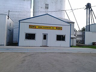
Edna is an unincorporated town in Lyon County, Iowa, United States. Edna is located on the western border of Liberal Township in Lyon County. It is located 6 miles (10 km) southeast of Rock Rapids, the county seat.
Olaf is an unincorporated community in Wright County, Iowa, United States.
Faulkner is an unincorporated community in Osceola Township, Franklin County, Iowa, United States. Faulkner is located along county highways C55 and S56, 4.5 miles (7.2 km) north-northwest of Ackley.
Depew is an unincorporated community in Independence Township, Palo Alto County, Iowa, United States. Depew is located along county highways B20 and N60, 8.7 miles (14.0 km) northeast of Emmetsburg.
Albaton is an unincorporated community in Fairview Township, Monona County, Iowa, United States. Albaton is located in the northwest corner of the county, 4.8 miles (7.7 km) southwest of Sloan.
Lorah is an unincorporated community in Pymosa Township, Cass County, Iowa, United States. Lorah is located along U.S. routes 6 and 71, 5.5 miles (8.9 km) north-northeast of Atlantic.
Ladoga is an unincorporated community in Washington Township, Taylor County, Iowa, United States. Ladoga is located along County Route J35, 3 miles (4.8 km) west-southwest of Gravity.

Argo is an unincorporated community and census-designated place (CDP) in Scott County, Iowa, United States. It is in the eastern part of the county, 9 miles (14 km) northeast of Bettendorf and 5 miles (8 km) northwest of Le Claire.


