
Tyne and Wear is a metropolitan county in the North East region of England around the mouths of the rivers Tyne and Wear. It came into existence in 1974 after the passage of the Local Government Act 1972. It consists of the five metropolitan boroughs of South Tyneside, North Tyneside, City of Newcastle upon Tyne, Gateshead and City of Sunderland. It is bounded on the east by the North Sea, and has borders with Northumberland to the north and County Durham to the south.

The Metropolitan Borough of North Tyneside is a metropolitan borough of Tyne and Wear, in North East England, and is part of the Tyneside conurbation. The borough council's main office is at Cobalt Business Park in Wallsend. The local authority is North Tyneside Council.

Cramlington is a town and civil parish in Northumberland, England, 9 miles north of Newcastle upon Tyne. The name suggests a probable founding by the Danes or Anglo-Saxons. The population was 29,405 as of 2011 census data from Northumberland County Council. It sits on the border between Northumberland and North Tyneside with the traffic interchange at Moor Farm, Annitsford, linking the two areas.

North Shields is a town on the north bank of the River Tyne in North East England, eight miles (13 km) north-east of Newcastle upon Tyne. Historically part of Northumberland, its name derives from Middle English schele meaning "temporary sheds or huts used by fishermen".

Monkseaton is a village absorbed into Whitley Bay, North Tyneside, in the North East of England. It is in the north-east of the borough, 3⁄4 mile (1.2 km) from the North Sea coast and 1 1⁄2 miles (2.4 km) north of the River Tyne at North Shields. A mile to the north of Monkseaton, the extensive built-up areas of North Tyneside change abruptly into green belt stretching north into south-east Northumberland. The village is at an elevation of 130 feet (40 m) above sea-level.
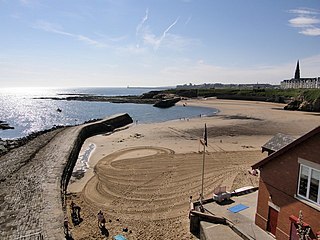
Cullercoats is a village and urban area of North East England, with a population 9,407 in 2004. It has now been absorbed into the North Tyneside conurbation, sitting between Tynemouth and Whitley Bay. The population of this North Tyneside ward at the 2011 census was 9,202.

Esh Winning is a village, and location of a former colliery, in County Durham, England. It is situated in the Deerness Valley 5 miles (8 km) to the west of Durham. The village was founded by the Pease family in the 1850s to service a new mine on the Esh Estate.

Marsden is located on the outskirts of the seaside town South Shields, North East England, located on the North Sea coast.
Wideopen, also occasionally spelled Wide Open, is a village in the administrative borough of North Tyneside, north of Gosforth and six miles (9.7 km) north of Newcastle upon Tyne city centre.
Backworth is a village in the metropolitan borough of North Tyneside in the county of Tyne and Wear, England, about 3 1⁄2 miles (6 km) west of Whitley Bay on the north east coast. It lies 5 miles (8 km) northeast of Newcastle. Other nearby towns include North Shields to the southeast, Wallsend to the south, and Cramlington to the northwest.

Seghill is a small village located on the Northumberland border which is the county boundary between Northumberland and Tyne and Wear. Seghill is situated between the villages of Seaton Delaval and Annitsford, about 8 miles (13 km) north of Newcastle upon Tyne.
Annitsford is a village located in North Tyneside, on the border between Tyne and Wear and Northumberland. The main conurbation of the village falls under the jurisdiction of the Borough of North Tyneside in Tyne and Wear.

Ashington is a town and civil parish in Northumberland, England, with a population of 27,864 at the 2011 Census. It was once a centre of the coal mining industry. The town is 15 miles (24 km) north of Newcastle upon Tyne, west of the A189 and bordered to the south by the River Wansbeck. The North Sea coast at Newbiggin-by-the-Sea is 3 miles (5 km) away.
Brunswick Village is a village split between North Tyneside and Newcastle upon Tyne, Tyne and Wear, England. It is situated approximately 6 miles north of Newcastle upon Tyne, and borders Hazlerigg, Dinnington and Wideopen. It was formerly known as Dinnington Colliery.
Coxlodge is an area situated between Fawdon, Gosforth and Kenton in Newcastle upon Tyne, England.
Open-pit coal mining in the United Kingdom is in decline. Output has fallen every year since 2010. In 2010, the United Kingdom was forecast to produce about ten million tonnes of coal a year from open-pit mines. Most came from Scotland, with the largest operator there being the Scottish Coal subsidiary of Scottish Resources Group. Actual production in 2010 was over 13 million tonnes but this has declined to less than 8 million tonnes in 2014.

Marley Hill is a former colliery village about six miles to the south west of Gateshead, near the border between Tyne and Wear and County Durham. It has been part of the Metropolitan Borough of Gateshead since 1974. Prior to this it was part of Whickham Urban District. It lies within the Whickham South & Sunniside electoral ward of the Blaydon parliamentary constituency. Neighbouring towns and villages include Burnopfield ; Sunniside, Gateshead ; Byermoor. Marley Hill, Sunniside, Burnopfield and Byermoor all share Whickham's "NE16" postcode prefix, despite Burnopfield sitting just over the border in County Durham. The actual area considered to be Marley Hill for postal purposes etc. is actually much larger than it would first appear, as there were originally more houses to the south and south east, nearer the colliery. Birkheads Cottages and Hedley Hall Farm are the farthest properties away from the village itself, these being about a mile to the south-east. Hedley Hall Farm's address is anomalously listed as "Hedley Lane, Sunniside", despite actually being further away from Sunniside than Birkheads Cottages, whose addresses read "Birkheads Lane, Marley Hill".
Marshall Cresswell (1833-1889) was a Northumberland born miner, poet and songwriter. His experiences to and from his job in Borneo were serialised later in the local newspaper.
Percy Main is a small village absorbed into North Shields, North East England. Historically in Northumberland, it is now part of Tyne and Wear.
Harton is a suburban area of South Shields, South Tyneside, North East England. It was historically a village, however as the urban area grew it merged with its adjacent villages to become part of the town. Some of the original village buildings are still intact today, such as St Peter's Church.

