Related Research Articles
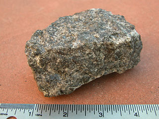
Gabbro is a phaneritic (coarse-grained), mafic intrusive igneous rock formed from the slow cooling of magnesium-rich and iron-rich magma into a holocrystalline mass deep beneath the Earth's surface. Slow-cooling, coarse-grained gabbro is chemically equivalent to rapid-cooling, fine-grained basalt. Much of the Earth's oceanic crust is made of gabbro, formed at mid-ocean ridges. Gabbro is also found as plutons associated with continental volcanism. Due to its variant nature, the term gabbro may be applied loosely to a wide range of intrusive rocks, many of which are merely "gabbroic". By rough analogy, gabbro is to basalt as granite is to rhyolite.

Dunite, also known as olivinite, is an intrusive igneous rock of ultramafic composition and with phaneritic (coarse-grained) texture. The mineral assemblage is greater than 90% olivine, with minor amounts of other minerals such as pyroxene, chromite, magnetite, and pyrope. Dunite is the olivine-rich endmember of the peridotite group of mantle-derived rocks.

The Pensacola Mountains are a large group of mountain ranges of the Transantarctic Mountains System, located in the Queen Elizabeth Land region of Antarctica.
The Forrestal Range is a largely snow-covered mountain range, about 105 km (65 mi) long, standing east of Dufek Massif and the Neptune Range in the Pensacola Mountains of Antarctica. Discovered and photographed on 13 January 1956 on a transcontinental patrol plane flight of U.S. Navy Operation Deep Freeze I from McMurdo Sound to the vicinity of the Weddell Sea and return.

Pyroxenite is an ultramafic igneous rock consisting essentially of minerals of the pyroxene group, such as augite, diopside, hypersthene, bronzite or enstatite. Pyroxenites are classified into clinopyroxenites, orthopyroxenites, and the websterites which contain both types of pyroxenes. Closely allied to this group are the hornblendites, consisting essentially of hornblende and other amphiboles.
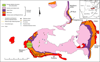
The Bushveld Igneous Complex (BIC) is the largest layered igneous intrusion within the Earth's crust. It has been tilted and eroded forming the outcrops around what appears to be the edge of a great geological basin: the Transvaal Basin. It is approximately 2 billion years old and is divided into four different limbs: the northern, southern, eastern, and western limbs. The Bushveld Complex comprises the Rustenburg Layered suite, the Lebowa Granites and the Rooiberg Felsics, that are overlain by the Karoo sediments. The site was first publicised around 1897 by Gustaaf Molengraaff who found the native South African tribes residing in and around the area.

A layered intrusion is a large sill-like body of igneous rock which exhibits vertical layering or differences in composition and texture. These intrusions can be many kilometres in area covering from around 100 km2 (39 sq mi) to over 50,000 km2 (19,000 sq mi) and several hundred metres to over one kilometre (3,300 ft) in thickness. While most layered intrusions are Archean to Proterozoic in age, they may be any age such as the Cenozoic Skaergaard intrusion of east Greenland or the Rum layered intrusion in Scotland. Although most are ultramafic to mafic in composition, the Ilimaussaq intrusive complex of Greenland is an alkalic intrusion.

Cumulate rocks are igneous rocks formed by the accumulation of crystals from a magma either by settling or floating. Cumulate rocks are named according to their texture; cumulate texture is diagnostic of the conditions of formation of this group of igneous rocks. Cumulates can be deposited on top of other older cumulates of different composition and colour, typically giving the cumulate rock a layered or banded appearance.
The Windimurra Igneous Complex is a giant ultramafic-mafic intrusion emplaced within the Yilgarn craton of Western Australia. It is located approximately 100 kilometres south east of the town of Mount Magnet.

Troctolite is a mafic intrusive rock type. It consists essentially of major but variable amounts of olivine and calcic plagioclase along with minor pyroxene. It is an olivine-rich anorthosite, or a pyroxene-depleted relative of gabbro. However, unlike gabbro, no troctolite corresponds in composition to a partial melt of peridotite. Thus, troctolite is necessarily a cumulate of crystals that have fractionated from melt.
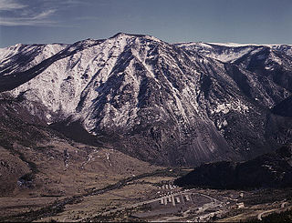
The Stillwater igneous complex is a large layered mafic intrusion (LMI) located in southern Montana in Stillwater, Sweet Grass and Park Counties. The complex is exposed across 30 miles (48 km) of the north flank of the Beartooth Mountain Range. The complex has extensive reserves of chromium ore and has a history of being mined for chromium. More recent mining activity has produced palladium and other platinum group elements.

The Skaergaard intrusion is a layered igneous intrusion in the Kangerlussuaq area, East Greenland. It comprises various rock types including gabbro, ferro diorite, anorthosite and granophyre.

Nolan B. Aughenbaugh is an American Professor Emeritus of Geological Engineering at the University of Mississippi.

The Southern Oklahoma Aulacogen(ah-lah-coh-jin) (help·info) is a failed rift, or failed rift arm (aulacogen), of the triple junction that became the Iapetus Ocean spreading ridges. It is a significant geological feature in the Western and Southern United States. It formed sometime in the early to mid Cambrian Period and spans the Wichita Mountains, Taovayan Valley, Anadarko Basin, and Hardeman Basin in Southwestern Oklahoma. The Southern Oklahoma Aulacogen is primarily composed of basaltic dikes, gabbros, and units of granitic rock.

La Negra Formation is a geologic formation of Jurassic age, composed chiefly of volcanic and volcaniclastic rocks, located in the Coast Range of northern Chile. The formation originated in marine and continental (terrestrial) conditions, and bears evidence of submarine volcanism as well as large explosive eruptions. The volcanism of La Negra Formation is thought to have lasted for about five million years.

The Okavango Dyke Swarm is a giant dyke swarm of the Karoo Large Igneous Province in northeast Botswana, southern Africa. It consists of a group of Proterozoic and Jurassic dykes, trending east-southeast across Botswana, spanning a region nearly 2,000 kilometres (1,200 mi) long and 110 kilometres (68 mi) wide. The Jurassic dykes were formed approximately 179 million years ago, composed of mainly tholeiitic mafic rocks. The formation is related to the magmatism at the Karoo triple junction, induced by the plate tectonic break up of the Gondwana supercontinent in the early Jurassic.
The lower oceanic crust is the lower part of the oceanic crust and represents the major part of it. It is generally located 4–8 km below the ocean floor and the major lithologies are mafic which derive from melts rising from the earth's mantle. This part of the oceanic crust is an important zone for processes such as melt accumulation and melt modification. And the recycling of this part of the oceanic crust, together with the upper mantle has been suggested as a significant source component for tholeiitic magmas in Hawaiian volcanoes. Although the lower oceanic crust builds the link between the mantle and the MORB, and can't be neglected for the understanding of MORB evolution, the complex processes operating in this zone remain unclear and there is an ongoing debate in Earth Sciences about this. It is 6KM long.

The geology of North Macedonia includes the study of rocks dating to the Precambrian and a wide array of volcanic, sedimentary and metamorphic rocks formed in the last 539 million years.

The geology of Peru includes ancient Proterozoic rocks, Paleozoic and Mesozoic volcanic and sedimentary rocks, and numerous basins and the Andes Mountains formed in the Cenozoic.
The Horokanai ophiolite is a geological complex located in the Kamuikotan tectonic belt about 30 km northwest of Asahikawa city, Hokkaido, Japan. The ophiolite complex is exposed along either side of a north-dipping anticline in several blocks.
References
- ↑ "Stratigraphy of the layered gabbroic Dufek Intrusion, Antarctica - ScienceBase-Catalog". www.sciencebase.gov. US: United States Geological Survey . Retrieved 2019-02-13.
- ↑ "Page 1 Stratigraphy of the Layered Gabbroic Dufek Intrusion, Antarctica" (PDF). US: United States Geological Survey.
- ↑ Behrendt, J. C.; Drewry, D. J.; Jankowski, E.; Grim, M. S. (1980-08-29). "Aeromagnetic and radio echo ice-sounding measurements show much greater area of the dufek intrusion, antarctica". Science. US. 209 (4460): 1014–1017. Bibcode:1980Sci...209.1014B. doi:10.1126/science.209.4460.1014. PMID 17747230. S2CID 7156310.
- ↑ S.D.Burgess, S.A.Bowring, T.H.Fleming & D.H.Elliot, 2015. High-precision geochronology links the Ferrar large igneous province with early-Jurassic ocean anoxia and biotic crisis. Earth and Planetary Science Letters, ISSN 0012-821X, Vol: 415, Page: 90-99
- ↑ Ford, Arthur; Himmelberg, Glen (1991). Tingey, Robert (ed.). Geology and crystallization of the Dufek intrusion, in The Geology of Antarctica. Oxford: Clarendon Press. pp. 175–214. ISBN 0198544677.
| | This article about igneous petrology is a stub. You can help Wikipedia by expanding it. |