
Maithili is an Indic language native to the Indian subcontinent, mainly spoken in India and Nepal. In India, it is spoken in the states of Bihar and Jharkhand and is one of the 22 recognised Indian languages. In Nepal, it is spoken in the eastern Terai and is the second most prevalent language of Nepal. It is also one of the 122 recognized Nepalese languages. Tirhuta was formerly the primary script for written Maithili. Less commonly, it was also written in the local variant of Kaithi. Today it is written in the Devanagari script.
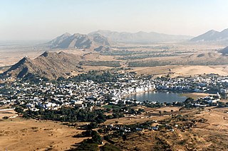
Pushkar is a town in the Ajmer district in the Indian state of Rajasthan. It is situated about 10 km (6.2 mi) northwest of Ajmer and about 150 kilometres (93 mi) southwest of Jaipur. It is a pilgrimage site for Hindus and Sikhs. Pushkar has many temples. Most of the temples and ghats in Pushkar are from the 18th century and later, because many temples were destroyed during Muslim conquests in the area. Subsequently, the destroyed temples were rebuilt. The most famous among Pushkar temples is the red spired Brahma Temple built during the 14th century CE. It is considered a sacred city by the Hindus particularly in Shaktism, and meat and eggs consumption are forbidden in the city. Pushkar is located on the shore of Pushkar Lake, which has many ghats where pilgrims bathe. Pushkar is also significant for its Gurdwaras for Guru Nanak and Guru Gobind Singh. One of the bathing ghats is called Gobind ghat built by the Sikhs in the memory of Guru Gobind Singh.

Araria is a city and a municipality that is the headquarters of Araria district in the state of Bihar, India. Araria is situated in the northern part of Bihar.
Purnia division is an administrative geographical unit of Bihar state of India. Purnia is the administrative headquarters of the division. The division consists of Purnia district, Katihar district, Araria district, and Kishanganj district in 2005. It is also known as Seemanchal. It is a part of the Kosi—Seemanchal subregion of the cultural Mithila region.
Birpur is a city and a notified area in Supaul district in the state of Bihar, India. It is a small town on the Indo-Nepal border near the historic Kosi Barrage on the Kosi River. It has an airstrip, which is being modernised and later on will be utilized for commercial as well defence use. It had been made when first prime minister of India Pandit Jawahar Lal Nehru had landed here to lay the foundation stone of Koshi Barrage. There has been a new helipad constructed next to the airstrip for multi purpose use.

Birgunj is a metropolitan city and border town in Parsa District in the Narayani Zone of southern Nepal. It lies 135 km (84 mi) south of the capital Kathmandu, attached in the north to Raxaul in the border of the Indian state of Bihar. As an entry point to Nepal from Patna and Kolkata, it is known as the "Gateway to Nepal". The town has significant economic importance for Nepal as most of the trade with India is via Birgunj and the Indian town of Raxaul. Tribhuvan Highway links Birgunj to Nepal's capital, Kathmandu. It was declared a Metropolitan City on 22 May 2017 along with Biratnagar and Pokhara. Birgunj is currently the second largest city in the Terai region of Nepal, and the sixth most populated metropolis of the nation.
Panauti is a municipality in Kavrepalanchok District in Province No. 3 of Nepal located 32 km Southeast of the capital Kathmandu. The town is currently listed as a UNESCO tentative site since 1996.
Maithils, also known as Maithili people, are an Indo-Aryan ethno-linguistic group from the Indian subcontinent, who speak the Maithili language and inhabit the Mithila region, which comprises Tirhut, Darbhanga, Kosi, Purnia, Munger, Bhagalpur and Santhal Pargana divisions of India and some adjoining districts of Nepal. The Maithil homeland forms an important part of Hindu mythology as it is said to be the birthplace of Sita, the wife of Ram. "Pure" Maithil culture is said to be found in the villages of Madhubani district in Bihar.

Janakpur is the headquarters of Dhanusa District at Province No. 2 in Nepal. The city is a centre for religious and cultural tourism. It has been declared as the temporary capital for Province no. 2 until Province Assembly votes for a permanent capital.
Mahendra Highway, also called East-West Highway runs across the Terai geographical region of Nepal, from Mechinagar in the east to Bhim Datta in the west, cutting across the entire width of the country. It is the longest highway in Nepal and was constructed by CPWD/PWD Nepali and Indian engineers.
Mithila, also known as Tirhut and Tirabhukti, is a geographical and cultural region of the Indian subcontinent, mainly located in the Indian state of Bihar. This region is bounded by the Mahananda River in the east, the Ganges in the south, the Gandaki River in the west and by the foothills of the Himalayas in the north. It extends into the eastern Terai of Nepal.

Jaleshwar is a municipality in Janakpur Zone, Nepal, and the headquarters of Mahottari District of Province No. 2 in Nepal. It is located in the Terai, on the border with India at Sursand, Bihar, and has a customs checkpoint.
The Punaura Dham, Janki Mandir is a Hindu pilgrimage site in Sitamarhi district, in the India in state of Bihar, which has an ancient Hindu temple. It is situated 5 km west of Sitamarhi town and a popular visitor's attraction.
Dharharwa is a village in Parihar Tehsil in Sitamarhi District in Bihar State, India. In Hindi: धरहरवा
Kakapora is a tehsil in Pulwama district, of the state of Jammu and Kashmir, India. It is located 20 kilometres (12 mi) to the south of Srinagar. The district road passes through the town, which connects it to the district headquarters at Pulwama. It is situated on the banks of the Jehlum River and Romshi, one of the tributaries of the Jhelum River. The people are mostly associated with agriculture. Kakapora is a historical place and is mentioned in Kalahana's book of Rajatarangini. In modern times, Kakapora is often referred to as the rice bowl of Kashmir. There are commercial units in Kakapora that boost the economic status of the town beyond just agriculture.
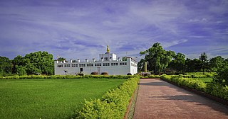
Maya Devi Temple is an ancient Buddhist temple situated at the UNESCO World Heritage Site of Lumbini, Nepal. It is the main temple at Lumbini, a site traditionally considered the birthplace of Gautama Buddha. The temple stands adjacent to a sacred pool and a sacred garden. The archaeological remains at the site were previously dated to the third-century BCE brick buildings constructed by Ashoka. A sixth-century BCE timber shrine was discovered in 2013.

Province No. 2 is a province in the southeastern region of Nepal that was formed after the adoption of the Constitution of Nepal. It is Nepal's second most populous province, and smallest province by area. It borders Province No. 1 to the east, Province No. 3 to the north, and India to the south. It has an area of 9,661 km2 (3,730 sq mi) with a population of 5,404,145 per the 2011 Census of Nepal, making it most densely populated province of Nepal.

Simraungadh, Simraongarh or Simroungarh was the fortified city and an ancient capital of the Tirhut Kingdom founded by Karnat Kshatriya King Nanyadeva in 1097. Presently it is a municipality of Nepal, located in Bara District, Province No. 2. The municipality was created in 2014 by agglomerating the Village Development Committees of Amritganj, Golaganj, Hariharpur & Uchidih; and later on expanded to include Bhagwanpur, Kachorwa, Dewapur-Teta, and Bishunpur
Choraut is a block in Sitamarhi district in the Indian state of Bihar.


