Dulgalakh River

Last updated
Dulgalakh
Дулҕалаах
Дулҕалаах
Yana river.png
Basin of the Yana.
Location
Country Yakutia, Russia
Physical characteristics
Mouth  
 - location
Confluence with the Sartang
 - elevation
132 m (433 ft)
Length507 km (315 mi)
Basin size27,300 km2 (10,500 sq mi)
Discharge 
 - average101 m3/s (3,600 cu ft/s)

Dulgalakh (Russian :Дулгалах; Yakut : Дулҕалаах, Dulğalaax) is a river in Yakutia, a left tributary of the Yana River. Its length is 507 km (315 mi) and its basin size 27,300 square kilometres (10,541 sq mi).

Russian language East Slavic language

Russian is an East Slavic language, which is official in the Russian Federation, Belarus, Kazakhstan and Kyrgyzstan, as well as being widely used throughout Eastern Europe, the Baltic states, the Caucasus and Central Asia. It was the de facto language of the Soviet Union until its dissolution on 25 December 1991. Although, nowadays, nearly three decades after the breakup of the Soviet Union, Russian is used in official capacity or in public life in all the post-Soviet nation-states, as well as in Israel and Mongolia, the rise of state-specific varieties of this language tends to be strongly denied in Russia, in line with the Russian World ideology.

Yakut language Turkic language spoken in Sakha Republic, Russia

Yakut, also known as Sakha, Saqa or Saxa, is a Turkic language with around 450,000 native speakers spoken in the Sakha Republic in the Russian Federation by the Yakuts.

Yana River river in Russia

The Yana River, is a river in Sakha in Russia, located between the Lena to the west and the Indigirka to the east.

Course

The Dulgalakh rises on the northern slopes of Verkhoyansk Range. It flows through Kobyaysky and Verkhoyansky districts. Above Verkhoyansk it merges with the Sartang River forming the Yana. [1]

Verkhoyansk Range mountain range

The Verkhoyansk Range is a mountain range of eastern Siberia spanning roughly 1000 km (600 mi.) across the Sakha Republic. It forms a vast arc between the Lena and Aldan rivers to the west and the Yana River to the east. It rises to c. 2,480 m (8,150 ft) in the south. There are coal, silver, lead, and zinc deposits located in the mountains. It lies just west of the boundary of the Eurasian and the North American tectonic plates.

Kobyaysky District District in Sakha Republic, Russia

Kobyaysky District is an administrative and municipal district, one of the thirty-four in the Sakha Republic, Russia. It is located in the center of the republic on the Vilyuy River, 334 kilometers (208 mi) by road north of the republic's capital of Yakutsk. The area of the district is 107,800 square kilometers (41,600 sq mi). Its administrative center is the urban-type settlement of Sangar. As of the 2010 Census, the total population of the district was 13,680, with the population of Sangar accounting for 32.0% of that number.

Verkhoyansky District District in Sakha Republic, Russia

Verkhoyansky District is an administrative and municipal district, one of the thirty-four in the Sakha Republic, Russia. It is located in the northern central part of the republic and borders with Ust-Yansky District in the northeast, Momsky District in the east, Tomponsky District in the south, Kobyaysky District in the southwest, Eveno-Bytantaysky National District in the west, and with Bulunsky District in the northwest. The area of the district is 137,400 square kilometers (53,100 sq mi). Its administrative center is the urban locality of Batagay. Population: 12,815 (2010 Census); 13,666 ; 24,259 (1989 Census). The population of Batagay accounts for 34.1% of the district's total population.

Related Research Articles

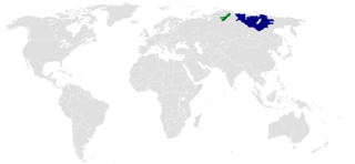
The Poles of Cold are the places in the southern and northern hemispheres where the lowest air temperatures have been recorded.

Chersky Range mountain range

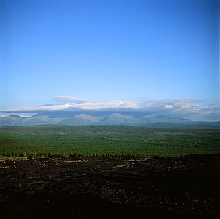
The Chersky Range is a chain of mountains in northeastern Siberia between the Yana River and the Indigirka River. It generally runs from northwest to southeast through the Sakha Republic and Magadan Oblast. The highest peak in the range is Peak Pobeda, which is 3,003 meters tall. The range lies on the boundary between the Eurasian and North American tectonic plates. The Chersky mountains, along with the neighboring Verkhoyansk Range, have a moderate effect on the climate of Siberia. The ridges obstruct west-moving air flows, decreasing the amount of snowfall in the plains to the west.

Huanta Province Province in Ayacucho, Peru

Huanta Province is the northernmost of the eleven provinces in the Ayacucho region in Peru. The capital of the Huanta province is the city of Huanta.

Bruntál District District in Moravian-Silesian Region, Czech Republic

Bruntál District is a district (okres) within Moravian-Silesian Region of the Czech Republic. Its capital is Bruntál, but the biggest town is Krnov. Part of the district belongs to Moravia, while another part belongs to Czech Silesia.

Ilya Perfilyev (Perfiryev), was a Russian explorer, polar seafarer and a founder of Verkhoyansk. In the summer of 1633 he headed a group, consisted of merchant-and-industrial people and Yenisey and Tobolsk Cossacks. In 1634 he discovered the Yana River and the Yana-Indigirka lowland.

Šmarna Gora District District of Ljubljana

The Šmarna Gora District, or simply Šmarna Gora, is a district of the City Municipality of Ljubljana, the capital of Slovenia. It has been named after Mount Saint Mary, an inselberg in the north of the city of Ljubljana.

Bębnów, Świętokrzyskie Voivodeship Village in Świętokrzyskie, Poland

Bębnów is a village in the administrative district of Gmina Gowarczów, within Końskie County, Świętokrzyskie Voivodeship, in south-central Poland. It lies approximately 5 kilometres (3 mi) south-west of Gowarczów, 6 km (4 mi) north of Końskie, and 44 km (27 mi) north of the regional capital Kielce.

Trawniki, Świętokrzyskie Voivodeship Village in Świętokrzyskie, Poland

Trawniki is a village in the administrative district of Gmina Smyków, within Końskie County, Świętokrzyskie Voivodeship, in south-central Poland. It lies approximately 5 kilometres (3 mi) east of Smyków, 17 km (11 mi) south of Końskie, and 23 km (14 mi) north-west of the regional capital Kielce.

Rybno, Konin County Village in Greater Poland, Poland

Rybno is a village in the administrative district of Gmina Wierzbinek, within Konin County, Greater Poland Voivodeship, in west-central Poland. It lies approximately 6 kilometres (4 mi) south-west of Wierzbinek, 25 km (16 mi) north-east of Konin, and 106 km (66 mi) east of the regional capital Poznań.

Pólko, Szamotuły County Village in Greater Poland, Poland

Pólko is a village in the administrative district of Gmina Kaźmierz, within Szamotuły County, Greater Poland Voivodeship, in west-central Poland. It lies approximately 12 kilometres (7 mi) south-west of Szamotuły and 34 km (21 mi) north-west of the regional capital Poznań.

Wilkowo, Lubusz Voivodeship Village in Lubusz, Poland

Wilkowo is a village in the administrative district of Gmina Świebodzin, within Świebodzin County, Lubusz Voivodeship, in western Poland. It lies approximately 5 kilometres (3 mi) west of Świebodzin, 36 km (22 mi) north of Zielona Góra, and 56 km (35 mi) south of Gorzów Wielkopolski.

Zielonówek Village in Warmian-Masurian, Poland

Zielonówek is a village in the administrative district of Gmina Olecko, within Olecko County, Warmian-Masurian Voivodeship, in northern Poland. It lies approximately 3 kilometres (2 mi) west of Olecko and 132 km (82 mi) east of the regional capital Olsztyn.

Lejkowo, West Pomeranian Voivodeship Village in West Pomeranian, Poland

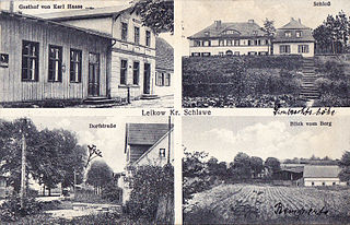
Lejkowo is a village in the administrative district of Gmina Malechowo, within Sławno County, West Pomeranian Voivodeship, in north-western Poland. It lies approximately 9 kilometres (6 mi) south-east of Malechowo, 15 km (9 mi) south-west of Sławno, and 161 km (100 mi) north-east of the regional capital Szczecin.

Buford, Alberta

Buford is a hamlet in central Alberta, Canada within Leduc County. It is located 2 kilometres (1.2 mi) south of Highway 39, 23 kilometres (14 mi) west of Leduc.

Gababedji is a village and rural commune in Niger.

Oud-Charlois is a neighborhood of Rotterdam, Netherlands.

Sartang River river in Russia

The Sartang River is a river in the Republic of Sakha in Russia. It is an easterly offshoot of the Yana, and is 620 kilometres (390 mi) long, with a drainage basin of 17,800 square kilometres (6,900 sq mi).

References

  1. Дулгалах — статья из Большой советской энциклопедии. Great Soviet Encyclopedia

Coordinates: 67°27′51″N133°14′51″E / 67.46417°N 133.24750°E / 67.46417; 133.24750

Geographic coordinate system Coordinate system

A geographic coordinate system is a coordinate system that enables every location on Earth to be specified by a set of numbers, letters or symbols. The coordinates are often chosen such that one of the numbers represents a vertical position and two or three of the numbers represent a horizontal position; alternatively, a geographic position may be expressed in a combined three-dimensional Cartesian vector. A common choice of coordinates is latitude, longitude and elevation. To specify a location on a plane requires a map projection.