The Mojave Desert is a desert in the rain shadow of the Sierra Nevada mountains in the Southwestern United States. It is named for the indigenous Mojave people. It is located primarily in southeastern California and southwestern Nevada, with small portions extending into Arizona and Utah.

Mojave National Preserve is a United States National Preserve located in the Mojave Desert of San Bernardino County, California, USA, between Interstate 15 and Interstate 40. The preserve was established October 31, 1994, with the passage of the California Desert Protection Act by the US Congress, which also established Joshua Tree National Park and Death Valley National Park as National Parks. Previously, some lands contained within the Preserve were the East Mojave National Scenic Area, under the jurisdiction of the Bureau of Land Management. At 1,542,776 acres (6,243 km2), within the contiguous United States it is the third largest unit of the National Park System and the first largest National Preserve. The preserve was created within the Pacific West Region of the National Park Service and remains within that jurisdiction today.

The Mojave River is an intermittent river in the eastern San Bernardino Mountains and the Mojave Desert in San Bernardino County, California, United States. Most of its flow is underground, while its surface channels remain dry most of the time, except for the headwaters and several bedrock gorges in the lower reaches.

The Amargosa River is an intermittent waterway, 185 miles (298 km) long, in southern Nevada and eastern California in the United States. It drains a high desert region, the Amargosa Valley in the Amargosa Desert northwest of Las Vegas, into the Mojave Desert, and finally into Death Valley where it disappears into the ground aquifer. Except for a small portion of its route in the Amargosa Canyon in California and a small portion at Beatty, Nevada, the river flows above ground only after a rare rainstorm washes the region. A 26-mile (42 km) stretch of the river between Shoshone and Dumont Dunes is protected as a National Wild and Scenic River. At the south end of Tecopa Valley the Amargosa River Natural Area protects the habitat.
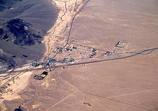
Baker is a census-designated place located in San Bernardino County, California, US. As of the 2010 census, the CDP had a total population of 735. Baker's ZIP Code is 92309 and the community is within area codes 442 and 760.

Off-roading is the activity of driving or riding in a vehicle on unpaved surfaces such as sand, gravel, riverbeds, mud, snow, rocks, and other natural terrain. Types of off-roading range in intensity, from leisure drives with unmodified vehicles, to competitions with customised vehicles and professional drivers. Off-roaders have been met with criticism for the environmental damage caused by their vehicles. There have also been extensive debates over the role of government in regulating the sport, including a Supreme Court case brought against the Bureau of Land Management in the United States.

The Amargosa Desert is located in Nye County in western Nevada, United States, along the California–Nevada border, comprising the northeastern portion of the geographic Amargosa Valley, north of the Ash Meadows National Wildlife Refuge.

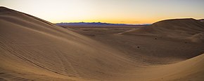
The Algodones Dunes is a large sand dune field, or erg, located in the southeastern portion of the U.S. state of California, near the border with Arizona and the Mexican state of Baja California. The field is approximately 45 miles (72 km) long by 6 miles (9.7 km) wide and extends along a northwest-southeast line that correlates to the prevailing northerly and westerly wind directions. The name "Algodones Dunes" refers to the entire geographic feature, while the administrative designation for that portion managed by the Bureau of Land Management is the Imperial Sand Dunes Recreation Area. In 1966, Imperial Sand Hills was designated as a National Natural Landmark by the National Park Service. The Algodones Dunes are split into many different sections. These sections include Glamis, Gordon's Well, Buttercup, Midway, and Patton's Valley. Although the Arabic-derived Spanish word algodones translates to "cotton plants", the origin of the toponym is unknown.

The Jawbone–Butterbredt Area of Critical Environmental Concern (ACEC), is located in the Mojave Desert and Southern Sierra Nevada, northwest of California City and California State Route 14, in Kern County, California.

The Mojave Road, also known as Old Government Road, is a historic route and present day dirt road across what is now the Mojave National Preserve in the Mojave Desert in the United States. This rough road stretched 147 miles (237 km) from Beale's Crossing, to Fork of the Road location along the north bank of the Mojave River where the old Mojave Road split off from the route of the Old Spanish Trail/Mormon Road.

The Kiavah Wilderness is a federally designated wilderness area located in the Mojave Desert, Scodie Mountains, and southern Sierra Nevada in Kern County, California, United States. California State Route 178 connects the town of Lake Isabella to State Highway 14 in the east, crossing Walker Pass at the north boundary of the wilderness.
Rasor Off-Highway Vehicle Area is a remote public use area for the off-highway vehicle user located in the Mojave Desert about 50 miles (80 km) east of Barstow, California, administered by the Bureau of Land Management.
The Piper Mountain Wilderness is a federally designated wilderness area located in the White Mountains 20 miles (32 km) northeast of Big Pine, California in Inyo County, California.

The Christmas Valley Sand Dunes are a natural sand dune complex covering 11,000 acres (45 km2) of public lands east of Christmas Valley in Lake County, Oregon, United States, about 100 miles (160 km) southeast of Bend. The area is accessible via the Christmas Valley National Back Country Byway. The dunes are up to 60 feet (18 m) high. It is the largest inland shifting sand dune system in the Pacific Northwest. The dunes are composed mostly of ash and pumice from the eruption of Mount Mazama that formed Crater Lake 7,000 years ago. Approximately 8,900 acres (36 km2) of dunes are open to vehicles.

The Chimney Peak Wilderness is a 13,134-acre (53.15 km2) wilderness area located 20 miles (32 km) northwest of Ridgecrest, in southeastern Tulare County, California.
The California Desert Protection Act of 2010 was legislation proposed by U.S. Senator Dianne Feinstein. The stated aim of the legislation was "to provide for conservation, enhanced recreation opportunities, and development of renewable energy in the California Desert Conservation Area."

The Clipper Mountain Wilderness is a wilderness area in the Clipper Mountains of the eastern Mojave Desert and within Mojave Trails National Monument, located in northeastern San Bernardino County, California. It is under the jurisdiction of the Bureau of Land Management.
Knolls is an unincorporated community in north-central Tooele County, Utah, United States.

Mojave Trails National Monument is a large U.S. National Monument located in the state of California between Interstates 15 and 40. It partially surrounds the Mojave National Preserve. It was designated by President Barack Obama on February 12, 2016, along with Castle Mountains National Monument and Sand to Snow National Monument, also in southern California. It is under the administration of the Bureau of Land Management.

Sand to Snow National Monument is a U.S. National Monument located in San Bernardino County and northern Riverside County, Southern California.