
Tyngsborough is a town in northern Middlesex County, Massachusetts, United States. Tyngsborough is 28 miles (45 km) from Boston along the Route 3 corridor, and located on the New Hampshire state line. At the 2010 census, the town population was 11,292. By its location, the town serves as a suburb of neighboring cities such as Nashua, New Hampshire and Lowell, Massachusetts.

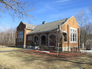
Hollis is a town in Hillsborough County, New Hampshire, United States. The population was 7,684 at the 2010 census, with an estimated population of 8,006 as of 2019. The town center village is listed on the National Register of Historic Places as Hollis Village Historic District.
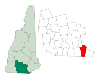
Litchfield is a town in Hillsborough County, New Hampshire, United States. The population was 8,271 at the 2010 census, with an estimated population in 2017 of 8,502.

Merrimack is a town in Hillsborough County, New Hampshire, United States. The population was 26,632 as of the 2020 census.

Nashua is a city in southern New Hampshire, United States. As of the 2020 census, it had a population of 91,322, the second-largest in northern New England after nearby Manchester. Along with Manchester, it is a seat of New Hampshire's most populous county, Hillsborough.
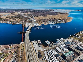
The Merrimack River is a 117-mile-long (188 km) river in the northeastern United States. It rises at the confluence of the Pemigewasset and Winnipesaukee rivers in Franklin, New Hampshire, flows southward into Massachusetts, and then flows northeast until it empties into the Gulf of Maine at Newburyport. From Pawtucket Falls in Lowell, Massachusetts, onward, the Massachusetts–New Hampshire border is roughly calculated as the line three miles north of the river.

Londonderry is a town in western Rockingham County, New Hampshire, United States. It sits between Manchester and Derry, the largest and fourth-largest communities in the state. The population was 25,826 at the 2020 census. Londonderry is known for its apple orchards and is home to the headquarters of Stonyfield Farm and part of Manchester-Boston Regional Airport.
Hudson is a town in Hillsborough County, New Hampshire, United States. It is located along the Massachusetts state line. The population was 24,467 at the 2010 census, with an estimated population of 25,619 in 2019. It is the tenth-largest municipality in the state, by population.
New Hampshire Route 3A is a designation held by two separate state highways in New Hampshire. The two segments, although not directly connected, are linked by U.S. Route 3, from which they derive their route number.

New Hampshire Route 111 is a 50.027-mile-long (80.511 km) east–west highway in Hillsborough and Rockingham counties in southeastern New Hampshire. The road runs from the Massachusetts border at Hollis to North Hampton on the Atlantic shore.
Daniel Webster Highway is the name for several sections of U.S. Route 3 in New Hampshire. The highway is named after 19th century statesman Daniel Webster, a New Hampshire native.

The Nashua Manufacturing Company was a cotton textile manufacturer in Nashua, New Hampshire that operated from 1823 to 1945. It was one of several textile companies that helped create what became the city of Nashua, creating roads, churches and its own bank as part of the process. Like most New England textile mills it struggled during the Depression. It shut after World War II, when much of the industry had moved South for cheaper labor and land.
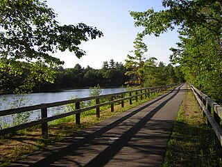
The Nashua River Rail Trail is a 12.5-mile (20.1 km) paved mixed-use rail trail in northern Massachusetts and southern New Hampshire under control of the Massachusetts Department of Conservation and Recreation (DCR). It roughly follows the course of the Nashua River, passing through the towns of Ayer, Groton, Pepperell, and Dunstable, Massachusetts and ends about a mile across the New Hampshire state border in Nashua, New Hampshire. The trail is used by walkers, cyclists, inline skaters, equestrians, and cross-country skiers.

The Circumferential Highway is the common name for a bypass route around the city of Nashua in southern New Hampshire, most of which has not yet been built. The purpose of the highway is to provide easier access to the F.E. Everett Turnpike and U.S. Route 3 in Nashua. Most of the highway is planned to be built in Hudson, with small sections also built through the towns of Litchfield and Merrimack as well as the city of Nashua.

Salmon Brook is one of the six major tributaries of the Merrimack River in northeastern Massachusetts in the United States. Its watershed is 31 square miles (80 km2) and is one of the 14 subwatersheds of the Merrimack River. It passes through Dunstable, Massachusetts, and Nashua, New Hampshire.
The Worcester, Nashua and Rochester Railroad was a railroad line that was to link the city of Worcester, Massachusetts, to the city of Portland, Maine, via the New Hampshire cities of Nashua and Rochester, by merging several small shortline railroads together.

The Merrimack Valley is a bi-state region along the Merrimack River in the U.S. states of New Hampshire and Massachusetts. The Merrimack is one of the larger waterways in New England and has helped to define the livelihood and culture of those living along it for millennia.

The Nashville Historic District in Nashua, New Hampshire is a historic district that was listed on the National Register of Historic Places (NRHP) in 1984. It encompasses an area just north of downtown Nashua, roughly centered on the junction of Concord, Amherst, and Main streets. Its southern bound is the Nashua River and Railroad Square, its eastern bounds are Railroad Square, Clinton, Lock, Orange, and Concord streets, its northern bound is Mount Pleasant Street, and its western boundary is Abbott, Amherst, Concord, and Main streets between the northern and southern bounds.

The Nashua Manufacturing Company Historic District in Nashua, New Hampshire, is a historic district that was listed on the National Register of Historic Places (NRHP) in 1987. It encompasses an area just west of downtown Nashua, roughly located along the southern bank of the Nashua River, bordered on the west side by Mine Falls Park, on the south side by the Nashua River canal, up to Ledge Street, and from the east side by Factory, Pine and Water streets, up to the Main Street bridge.

Pennichuck Brook is one of the tributaries of the Merrimack River in New Hampshire in the United States. Its watershed is 31 square miles (80 km2) and is one of the 14 subwatersheds of the Merrimack River. It passes through Nashua and Merrimack, New Hampshire and serves as the public water supply for greater Nashua.
