
Medicine Hat is a city in southeast Alberta, Canada. It is located along the South Saskatchewan River. It is approximately 169 km (105 mi) east of Lethbridge and 295 km (183 mi) southeast of Calgary. This city and the adjacent Town of Redcliff to the northwest are within Cypress County. Medicine Hat was the eighth-largest city in Alberta in 2021 with a population of 63,271. It is also the sunniest place in Canada according to Environment and Climate Change Canada, averaging 2,544 hours of sunshine a year.

The Cypress Hills are a geographical region of hills in southwestern Saskatchewan and southeastern Alberta, Canada. The hills are part of the Missouri Coteau upland. The hills cover an area of approximately 2,500 km2 (970 sq mi). About 400 km2 (150 sq mi) or 16% of this area is an interprovincial park.
Eagle Butte is a rural area south of Medicine Hat and west of the Cypress Hills. It is home to Saint Margaret's Church. Formerly there was a NWMP post in the area. The first post office opened in 1900. The locality takes its name from a nearby butte of the same name. It is near the location of a confirmed impact crater 10 km in diameter at 49°42'N110°31'W around 65 million years ago.

Medicine Hat was a provincial electoral district in Alberta, Canada, mandated to return members to the Legislative Assembly of Alberta from 1905 to 1971, and again from 1979 to 2019. The electoral district was named after the City of Medicine Hat.
Redcliff is a town in southern Alberta, Canada. Adjacent to the City of Medicine Hat to the east and Cypress County to the west and north, the town is bisected by Highway 1 and is located on the north bank of the South Saskatchewan River.
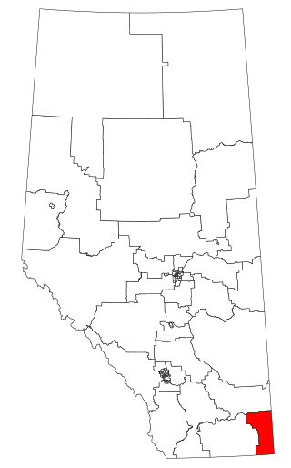
Cypress-Medicine Hat is a provincial electoral district in the southeast corner of Alberta.
Irvine is a hamlet in Alberta, Canada within Cypress County. It is located approximately 35 kilometres (22 mi) east of Medicine Hat on Highway 1 and has an elevation of 763 metres (2,503 ft). The hamlet is located in census division No. 1 and in the federal riding of Medicine Hat.
Cypress Hills Interprovincial Park is a natural park in Canada straddling the Alberta / Saskatchewan boundary and jointly administered by the two provinces. Located south-east of Medicine Hat in the Cypress Hills, it became Canada's first interprovincial park in 1989.
Highway 1 is a major east–west highway in southern Alberta that forms the southern mainline of the Trans-Canada Highway. It runs from the British Columbia border near Lake Louise through Calgary to the Saskatchewan border east of Medicine Hat. It continues as Highway 1 into both provinces. It spans approximately 534 km (332 mi) from Alberta's border with British Columbia in the west to its border with Saskatchewan in the east. Highway 1 is designated as a core route in Canada's National Highway System and is a core part of the developing Alberta Freeway Network.

Division No. 1 is a census division in Alberta, Canada. It is located in the southeast corner of southern Alberta and surrounds the City of Medicine Hat. The division is made up of the counties of Cypress and Forty Mile No. 8.

Prairie College is an interdenominational Christian College located in the town of Three Hills, Alberta, Canada. Founded as Prairie Bible Institute, classes began on October 9, 1922, on the property of the McElheran family farm.
The Public School Boards' Association of Alberta (PSBAA) is a not-for-profit society, the members of which can be any public school jurisdiction, or First Nations Education Authority, in Alberta, Canada. The membership criteria for the Association requires a school jurisdiction which provides public education to affirm its support to the Objects of the Association.

Highway 41, officially named Buffalo Trail, is a 686-kilometre (426 mi) north-south highway in eastern Alberta, Canada. It extends from the United States border at Wild Horse to Highway 55 in the hamlet of La Corey north of Bonnyville. Highway 41, along with Highway 36 and Highway 63, is part of the Eastern Alberta Trade Corridor, an economic development corridor that links the oil sands with Texas and Mexico, and works in association with the North American Ports-to-Plains Alliance.
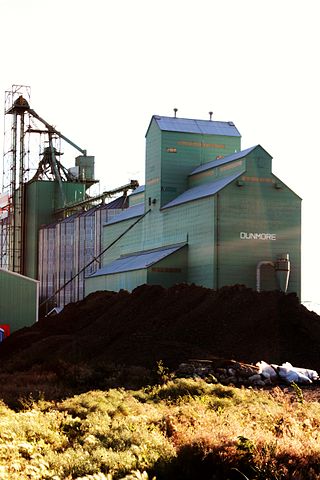
Dunmore is a hamlet in Alberta, Canada, within Cypress County, 2.6 kilometres (1.6 mi) southeast of Medicine Hat's city limits on Highway 1 and the Canadian Pacific Railway mainline. A portion of the hamlet is recognized as a designated place by Statistics Canada.
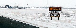
Cypress County is a municipal district in southeastern Alberta, Canada that surrounds the City of Medicine Hat and the Town of Redcliff. The municipality is part of Census Division 1, Alberta. The first farm in the area was settled in 1890.
The Alberta Colleges Athletic Conference (ACAC) is the governing body for collegiate sports in Alberta, Canada. Founded in 1964, as the Western Inter-College Conference, the ACAC is represented by eighteen schools, including one in Saskatchewan, that compete in ten sports.

Medicine Hat Transit is the municipal public transportation system operated by Medicine Hat, a small city in southeastern Alberta, Canada. Service is available and accessible to all residents of the community, including specialized transit for persons with disabilities; all of the MHT fleet is fully wheelchair-accessible.
The Shortgrass Library System consists of fourteen member public libraries in Southeast Alberta, Canada. The system headquarters is located in Medicine Hat. It has the distinction of being the first regional library system in the province of Alberta to have all eligible municipalities as members of a library system. Shortgrass was created by the Alberta government in 1988 as the fifth library system in the province. Services provided by Shortgrass for member libraries include cataloguing, deliveries, maintenance of the automated library system, IT support, and licensing of digital content.
Alberta Provincial Highway No. 48, commonly referred to as Highway 48, has been the designation of two separate highways in Alberta's history. The first was a north–south highway in southern Alberta, Canada that existed between the 1950s and 1979. It now forms the southernmost portion of Highway 41. The current Alberta highway 48 connects to Northwest Territories Highway 5 at the Northwest Territories border in Fort Smith NWT to Fort Fitzgerald and Hay Camp Road. The road was chip sealed in July 2021.

