Earlswood, Monmouthshire

Last updated
Earlswood
Tiny isolated Methodist chapel - geograph.org.uk - 301154.jpg
Methodist chapel
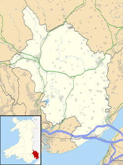
Monmouthshire UK location map.svg
Red pog.svg
Earlswood
Location within Monmouthshire
Principal area
Preserved county
Country Wales
Sovereign state United Kingdom
Post town USK
Postcode district NP
Police Gwent
Fire South Wales
Ambulance Welsh
UK Parliament
List of places
UK
Wales
Monmouthshire
51°39′41″N2°48′15″W / 51.6615°N 2.8043°W / 51.6615; -2.8043

Earlswood (Welsh: Coed-yr-iarll) is a rural area of scattered settlement in Monmouthshire, south east Wales, United Kingdom. It is located five miles northwest of Chepstow, within the parish of Shirenewton and immediately east of the forested area of Wentwood.
Contents

History

Earlswood Valley Methodist Chapel Earlswood chapel.jpg
Earlswood Valley Methodist Chapel

Before the Norman invasion of Wales, the area was largely forested. At the time of the Domesday Book it formed part of the estates of Durand, the Sheriff of Gloucester. He and his successors began the process of woodland clearance, and established the village of "Sheriff's Newton", now Shirenewton. Later, in the 12th century, the post of Sheriff was held by Milo Fitzwalter (Miles de Gloucester), who became Earl of Hereford and Lord High Constable of England, and the hilly area north west of Shirenewton became known as the Earl's Wood. [1]

Earlswood Methodist Chapel dates from 1791. Built of rubble stone and Welsh slate, it is largely unaltered, although John Newman, in his Gwent/Monmouthshire volume in the Pevsner Buildings of Wales series, records an extension dating from 1908. [2] [3]

A school was built in the area in 1861 for a maximum of 80 students. [4] It has since been closed down.

The village today

Today the village has a large community building built with publicly donated money, as a memorial to members of the parish who were killed in World War II. The building hosts many events for the parish. [5]

Related Research Articles

<span class="mw-page-title-main">Usk</span> Town in Monmouthshire, Wales

Usk is a town and community in Monmouthshire, Wales, 10 miles (16 km) northeast of Newport. It is located on the River Usk, which is spanned by an arched stone bridge at the western entrance to the town. Usk Castle, above the town, overlooks the ancient crossing point. It developed as a small market town, with some industry including the making of Japanware, and with a notable prison built in 1841/2. In recent years Usk has become known for its history of success in Britain in Bloom competitions, winning the Large Village award in 2005. The resident population of the town in 2001 was 2,318, increasing to 2,834 at the 2011 census.

<span class="mw-page-title-main">Caerwent</span> Human settlement in Monmouthshire, Wales

Caerwent is a village and community in Monmouthshire, Wales. It is located about five miles west of Chepstow and 11 miles east of Newport. It was founded by the Romans as the market town of Venta Silurum, an important settlement of the Brythonic Silures tribe. The modern village is built around the Roman ruins, which are some of the best-preserved in Europe. It remained prominent through the Roman era and Early Middle Ages as the site of a road crossing between several important civic centres. The community includes Llanvair Discoed. The village itself had a population of about 1,200.

<span class="mw-page-title-main">Rogiet</span> Human settlement in Wales

Rogiet Welsh: Rhosied is a small village and community in Monmouthshire, south east Wales, between Caldicot and Magor, 8 miles (13 km) west of Chepstow and 11 miles (18 km) east of Newport, which covers an area of 847 hectares (3.27 sq mi). It lies close to the M4 and M48 motorways, and the Second Severn Crossing. It has a railway station named Severn Tunnel Junction. Rogiet only has a population of 1,813 (2011).

<span class="mw-page-title-main">Magor, Monmouthshire</span> Human settlement in Wales

Magor is a large village in Monmouthshire, south east Wales, about 9 miles (14 km) west of Chepstow and about 9 miles (14 km) east of Newport. It lies on the Caldicot Levels beside the Severn Estuary, and is in the community of Magor with Undy. Magor lies close to the M4 motorway.

<span class="mw-page-title-main">Shirenewton</span> Village and community in Monmouthshire, Wales, UK

Shirenewton is a village and community in Monmouthshire, south east Wales. It is located 3 miles due west of Chepstow, 5 miles (8 km) by road. The village stands around 500 feet above sea level, and has extensive views of the Severn Estuary and Bristol Channel. The population of the village and the conjoined village of Mynydd-bach was 657 in 2011.

<span class="mw-page-title-main">Llanvair Discoed</span> Human settlement in Wales

Llanvair Discoed is a small village in Monmouthshire, south-east Wales, 6 miles west of Chepstow and 10 miles east of Newport.

<span class="mw-page-title-main">Raglan, Monmouthshire</span> Village in Monmouthshire, Wales

Raglan (; is a village and community in Monmouthshire, south east Wales, United Kingdom. It is located some 9 miles south-west of Monmouth, midway between Monmouth and Abergavenny on the A40 road very near to the junction with the A449 road. The fame of the village derives from Raglan Castle, built for William ap Thomas and now maintained by Cadw. The community includes the villages of Llandenny and Pen-y-clawdd. Raglan itself has a population of 1,183.

<span class="mw-page-title-main">Abergavenny Castle</span> Ruined castle in Abergavenny, Monmouthshire, Wales

Abergavenny Castle is a ruined castle in the market town of Abergavenny, Monmouthshire, Wales, established by the Norman lord Hamelin de Balun c. 1087. It was the site of a massacre of Welsh noblemen in 1175, and was attacked during the early 15th-century Glyndŵr Rising. William Camden, the 16th-century antiquary, said that the castle "has been oftner stain'd with the infamy of treachery, than any other castle in Wales."

<span class="mw-page-title-main">Mathern</span> Human settlement in Wales

Mathern is a historic community (parish) and village in Monmouthshire, south east Wales, about 3 miles (4.8 km) south west of the town of Chepstow, close to the Severn estuary, the Bristol Channel and the M48 motorway. The village is designated as a Conservation Area. It is now bisected by the motorway, which passes over the road through the village, with the original village located to the south and the more recent development, known as Newton Green, to the north.

<span class="mw-page-title-main">Llangattock-Vibon-Avel</span> Human settlement in Wales

Llangattock-Vibon-Avel is a rural parish and former community, now in the community of Whitecastle in Monmouthshire, south-east Wales, in the United Kingdom. It is located 5 miles (8.0 km) west of Monmouth and some 13 miles (21 km) east of Abergavenny, just off the B4233 old road between the two. Villages within the former community include Llangattock itself, Skenfrith, Rockfield, and Newcastle.

<span class="mw-page-title-main">Dingestow</span> Human settlement in Wales

Dingestow is a small village in Monmouthshire, Wales. It is located 4 miles (6.4 km) south-west of Monmouth and approximately the same distance north-east of Raglan in rural Monmouthshire. The River Trothy passes through the village.

<span class="mw-page-title-main">Mitchel Troy</span> Human settlement in Wales

Mitchel Troy is a village and community in Monmouthshire, south east Wales, in the United Kingdom. It is located 3 miles south west of the county town of Monmouth, just off the A40 road leading towards Raglan. Settlements within the community include Tregare, Dingestow, Cwmcarvan and Wonastow.

<span class="mw-page-title-main">Wolvesnewton</span> Small village in Monmouthshire, Wales, UK

Wolvesnewton is a small village in Monmouthshire, Wales.

<span class="mw-page-title-main">Llangwm, Monmouthshire</span> Human settlement in Wales

Llangwm is a small rural village and former community, now in the community of Llantrisant Fawr, in Monmouthshire, south east Wales. It is located 3 miles (4.8 km) east of Usk, on the B4235 Chepstow to Usk road. The main village is at Llangwm Uchaf, with a smaller and more dispersed settlement about 1 mile (1.6 km) to the north-east at Llangwm Isaf .The other settlement in the community is Llansoy. In 2022 the community was abolished and merged with Llantrisant Fawr.

<span class="mw-page-title-main">Llansoy</span> Village in Monmouthshire, Wales, UK

Llansoy is a small village in Monmouthshire, south east Wales, United Kingdom, located about 3 miles (4.2 km) south east of Raglan.

Newchurch is an extensive rural parish and small hamlet in Monmouthshire, south east Wales. It is located 6 miles south east of Usk and 6 miles north west of Chepstow, between the B4235 and B4293 roads.

<span class="mw-page-title-main">St Pierre, Monmouthshire</span> Human settlement in Wales

St Pierre is a former parish and hamlet in Monmouthshire, south east Wales, 3 miles (4.8 km) south west of Chepstow and adjacent to the Severn Estuary. It is now the site of a large golf and country club, the Marriott St Pierre Hotel & Country Club, which was previously a large manor house and deer park belonging to the Lewis family.

<span class="mw-page-title-main">Nash, Newport</span> Village and community in Wales

Nash is a village and community to the south of the city of Newport, South Wales, in the Lliswerry ward.

<span class="mw-page-title-main">Shirenewton Hall</span>

Shirenewton Hall, originally Shirenewton Court, is a country house and estate adjoining the village of Shirenewton, Monmouthshire, Wales, about 3 miles (4.8 km) west of Chepstow. The 29.5-acre (11.9 ha) estate is located on a hillside, and commands views across the "Golden Valley" to the west and the Severn estuary in the south. The main building was constructed around 1830, and partly rebuilt around 1900–1910, on the site of an earlier house which was the birthplace of William Blethyn, Bishop of Llandaff. The house is now a Grade II listed building, and the tea house in the adjoining Japanese garden is listed as Grade II*. The gardens are included on the Cadw/ICOMOS Register of Parks and Gardens of Special Historic Interest in Wales. The estate is not open to the public.

<span class="mw-page-title-main">Perth-hir House</span> House in Rockfield, Monmouthshire

Perth-hir House, Rockfield, Monmouthshire, Wales, was a major residence of the Herbert family. It stood at a bend of the River Monnow, to the north-west of the village. At its height in the 16th century, the mansion, entered by two drawbridges over a moat, comprised a great hall and a number of secondary structures. Subsequently in the ownership of the Powells, and then the Lorimers, the house became a centre of Catholic recusancy following the English Reformation. By the 19th century, the house had declined to the status of a farmhouse and it was largely demolished in around 1830. Its ruins, and the site which contains considerable remnants of a Tudor garden, are a scheduled monument.

References

  1. History of Shirenewton Church
  2. Cadw. "Earlswood Valley Methodist Chapel (Grade II) (24568)". National Historic Assets of Wales . Retrieved 23 September 2023.
  3. John Newman, The Buildings of Wales: Gwent/Monmouthshire, 2000, ISBN   0-14-071053-1
  4. "KELLY'S DIRECTORY OF MONMOUTHSHIRE, 1901". Freepages.genealogy.rootsweb.ancestry.com. Retrieved 25 May 2016.
  5. "Gallery - Earlswood Memorial Hall". Shirenewtoncc.org.uk. Retrieved 25 May 2016.