
South Andaman Island is the southernmost island of the Great Andaman and is home to the majority of the population of the Andaman Islands. It belongs to the South Andaman administrative district, part of the Indian union territory of Andaman and Nicobar Islands. It is the location of Port Blair, capital of the Andaman and Nicobar Islands.
North Andaman Island is the northern island of Great Andaman of the Andaman Islands. It belongs to the North and Middle Andaman administrative district, part of the Indian union territory of Andaman and Nicobar Islands. the island is lying 137 km (85 mi) north from Port Blair.
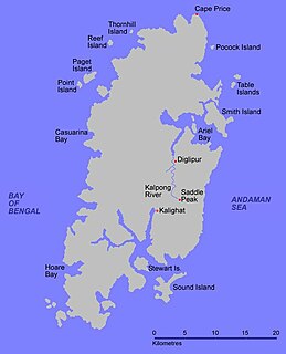
Middle Andaman Island is an island of the Andaman Islands. It belongs to the North and Middle Andaman administrative district, part of the Indian union territory of Andaman and Nicobar Islands.
Great Andaman is the main archipelago of the Andaman Islands of India. It comprises seven major islands. From north to south, these are North Andaman, Interview Island, Middle Andaman, Long Island, Baratang Island, South Andaman, and Rutland Island.
Baratang Island is an island of the Andaman Islands. It belongs to the North and Middle Andaman administrative district, part of the Indian union territory of Andaman and Nicobar Islands. The island lies 150 km north of Port Blair.
Interview Island is an island of the Andaman Islands. It belongs to the North and Middle Andaman administrative district, part of the Indian union territory of Andaman and Nicobar Islands. the island is lying 125 km (78 mi) north from Port Blair.
Strait Island is an island of the Andaman Islands. It belongs to the North and Middle Andaman administrative district, part of the Indian union territory of Andaman and Nicobar Islands. The island lies 63 km (39 mi) north from Port Blair.
Bluff Island is an island of the Andaman Islands. It belongs to the North and Middle Andaman administrative district, part of the Indian union territory of Andaman and Nicobar Islands. The island lies 64 km (40 mi) north from Port Blair.
Curlew Island is an island of the Andaman Islands. It belongs to the North and Middle Andaman administrative district, part of the Indian union territory of Andaman and Nicobar Islands. the island is lying 150 km (93 mi) north from Port Blair.
Stewart Island is an island of the Andaman Islands. It belongs to the North and Middle Andaman administrative district, part of the Indian union territory of Andaman and Nicobar Islands. the island is lying 150 km (93 mi) north from Port Blair. Its population only consists of two people.
Aves Island is an island of the Andaman Islands. It belongs to the North and Middle Andaman administrative district, part of the Indian union territory of Andaman and Nicobar Islands. The island lies 140 km (87 mi) north from Port Blair.
Spike Island is an island of the Andaman Islands. It belongs to the North and Middle Andaman administrative district, part of the Indian union territory of Andaman and Nicobar Islands. The island lies 63 km (39 mi) north from Port Blair.
Talakaicha Island is an island of the Andaman Islands. It belongs to the North and Middle Andaman administrative district, part of the Indian union territory of Andaman and Nicobar Islands. The island lies 65 km (40 mi) north from Port Blair.
Boning Island is an island of the Andaman Islands. It belongs to the North and Middle Andaman administrative district, part of the Indian union territory of Andaman and Nicobar Islands. The island lies 67 km (42 mi) north from Port Blair.
Belle Island is an island of the Andaman Islands. It belongs to the North and Middle Andaman administrative district, part of the Indian union territory of Andaman and Nicobar Islands. The island lies 58 km (36 mi) north from Port Blair.
West Baratang Group are an island group of the Andaman Islands, located west of Baratang Island.
Porlob Island is an island of the Andaman Islands. It belongs to the North and Middle Andaman administrative district, part of the Indian union territory of Andaman and Nicobar Islands. The island lies 81 km (50 mi) north from Port Blair.
Long Island is an island of the Andaman Islands. It belongs to the North and Middle Andaman administrative district, part of the Indian union territory of Andaman and Nicobar Islands. the island is lying 80 km (50 mi) north from Port Blair.
North Passage Island is an island of the Andaman Islands. It belongs to the North and Middle Andaman administrative district, part of the Indian union territory of Andaman and Nicobar Islands. The island lies 80 km (50 mi) north from Port Blair.
Colebrooke Island is an island of the Andaman Islands. It belongs to the North and Middle Andaman administrative district, part of the Indian union territory of Andaman and Nicobar Islands. The island lies 63 km (39 mi) north from Port Blair. It is named after Robert Hyde Colebrooke who surveyed the region along with Archibald Blair.
