
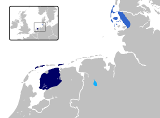
Frisia is a cross-border cultural region in Northwestern Europe. Stretching along the Wadden Sea, it encompasses the north of the Netherlands and parts of northwestern Germany. Wider definitions of "Frisia" may include the island of Rem and the other Danish Wadden Sea Islands. The region is traditionally inhabited by the Frisians, a West Germanic ethnic group.
Aurich is a district (Landkreis) in Lower Saxony, Germany. It is bounded by the North Sea, the districts of Wittmund and Leer, and the city of Emden.

Wittmund is a Landkreis (district) in the northwestern part of Lower Saxony, Germany. It is situated in East Frisia, on the North Sea coast. Neighboring districts are Friesland, Leer and Aurich.
Friesland is a district (Landkreis) in Lower Saxony, Germany. It is bounded by the districts of Wesermarsch, Ammerland, Leer and Wittmund, and by the North Sea. The city of Wilhelmshaven is enclosed by—but not part of—the district.
Leer is a district (Landkreis) in Lower Saxony, Germany. It is bounded by the city of Emden, the districts of Aurich, Wittmund, Friesland, Ammerland, Cloppenburg and Emsland, and by the Netherlands.

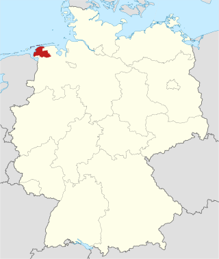
East Frisia or East Friesland is a historic region in modern Lower Saxony, Germany. The modern province is primarily located on the western half of the East Frisian peninsula, to the east of West Frisia and to the west of Landkreis Friesland but is known to have extended much further inland before modern representations of the territory. Administratively, East Frisia consists of the districts Aurich, Leer and Wittmund and the city of Emden. It has a population of approximately 469,000 people and an area of 3,142 square kilometres (1,213 sq mi).

Aurich is a town in the East Frisian region of Lower Saxony, Germany. It is the capital of the district of Aurich and is the second largest City in East Frisia, both in population, after Emden, and in area, after Wittmund.
Saterland Frisian, also known as Sater Frisian, Saterfrisian or Saterlandic, spoken in the Saterland municipality of Lower Saxony in Germany, is the last living dialect of the East Frisian language. It is closely related to the other Frisian languages: North Frisian, spoken in Germany as well, and West Frisian, spoken in the Dutch province of Friesland.
East Frisian is one of the Frisian languages. Its last surviving dialect is Saterland Frisian spoken in Saterland in Germany.

Wittmund is a town and capital of the district of Wittmund, in Lower Saxony, Germany.
Ems-Oriental was a department of the First French Empire in present-day Germany. It was formed in 1810, when the Kingdom of Holland was annexed by France. Its territory is part of the present-day German region of East Frisia in Lower Saxony. Its capital was Aurich. The department was subdivided into the following arrondissements and cantons :
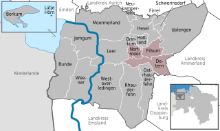
Jümme is a collective municipality (Samtgemeinde) in the district of Leer in the German state of Lower Saxony. It is named after the River Jümme which flows through all three constituent communities. It has an area of 82.34 km2 and a population of 6,421. It is situated in the region of East Frisia. Along with the Samtgemeinde of Hesel, it is one of two in the district. It was formed in the wake of local government reform in 1973. Filsum serves as the administrative centre.
The County of East Frisia was a county in the region of East Frisia in the northwest of the present-day German state of Lower Saxony.
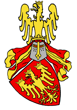
The tom Brok family were a powerful East Frisian line of chieftains, originally from the Norderland on the North Sea coast of Germany. From the second half of the 14th century, the tom Broks tried to gain control of East Frisia over the other chieftain families. The line of tom Brok died out in 1435.
The history of East Frisia developed rather independently from the rest of Germany because the region was relatively isolated for centuries by large stretches of bog to the south, while at the same time its people were oriented towards the sea. Thus in East Frisia in the Middle Ages there was little feudalism, instead a system of fellowship under the so-called Friesian Freedom emerged. It was not until 1464, that the House of Cirksena was enfeoffed with the Imperial County of East Frisia. Nevertheless absolutism had been, and continued to be, unknown in East Frisia. In the two centuries after about 1500, the influence of the Netherlands is discernable - politically, economically and culturally. In 1744, the county lost its independence within the Holy Roman Empire and became part of Prussia. Following the Vienna Congress of 1815, it was transferred to the Kingdom of Hanover, in 1866 it went back to Prussia and, from 1946, it has been part of the German state of Lower Saxony.
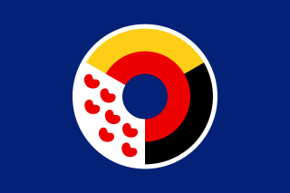
The flags of Frisia are the flags that are used to represent Frisia, a cross-border cultural region in Northwestern Europe. Some designs are in official use on a local or provincial level, while others are used unofficially on a regional, linguistic or international level.
The Saxon feud was a military conflict in the years 1514–1517 between the East Frisian Count Edzard I, 'West Frisian' rebels, the city of Groningen, and Charles II, Duke of Guelders on the one hand and the Imperial Frisian hereditary governor George, Duke of Saxony – replaced by Charles V of Habsburg in 1515 – and 24 German princes. The war took place predominantly on East Frisian soil and destroyed large parts of the region.

Norden is a railway station located in Norden in East Frisia, Lower Saxony, Germany. It is a junction station situated on the Emsland Railway line, with train services provided by Deutsche Bahn, and the historic Ostfriesische Küstenbahn. The latter is operated by a heritage train on Sundays from June to October.
The Interfrisian Council is a geopolitical organization that represents the common interests of the Frisians. The organization consists of three regional councils or "sections": North Frisia, East Frisia and West Frisia. Every three years, the presidency of the Interfrisian Council is handed over to another section. The council was established in 1956.

With more than 90 important organs from six centuries, the Organ landscape East Frisia is one of the richest organ landscapes in the world. The term organ landscape alone refers to the historically determined regional characteristics of the organs. 60 of the East Frisian organs date from before 1850. In addition, there are 15 historical Prospekt, behind which new Werke are installed. While Dutch organ building was influential for East Frisia in the 15th and 16th centuries, influences from Hamburg and Westphalia were added in the 17th and 18th centuries. East Frisian organ building in the 19th century was conservative until around 1870 and created instruments according to Baroque building principles. As relatively few new organs were built between 1870 and 1950, many historical instruments were preserved. Almost all of the original instruments have been restored in an exemplary manner over the last 50 years, bringing them back to their original sound and providing impetus for restoration practice and organ building worldwide. In recent decades, the public has become increasingly aware of the value of these instruments and the organ landscape of East Frisia has been made accessible to organ builders and organists from all over the world, as well as to the general public.
