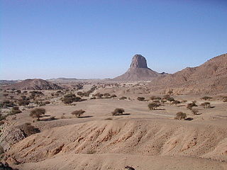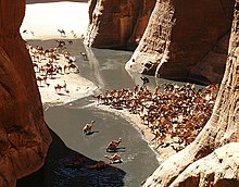
The Sahara desert, as defined by the World Wide Fund for Nature (WWF), includes the hyper-arid center of the Sahara, between latitudes 18° N and 30° N. It is one of several desert and xeric shrubland ecoregions that cover the northern portion of the African continent.

The Sahel region or Sahelian acacia savanna is a biogeographical region in Africa. It is the transition zone between the more humid Sudanian savannas to its south and the drier Sahara to the north. The Sahel has a hot semi-arid climate and stretches across the southernmost latitudes of North Africa between the Atlantic Ocean and the Red Sea. Although geographically located in the tropics, the Sahel does not have a tropical climate.

The Sahara is a desert spanning across North Africa. With an area of 9,200,000 square kilometres (3,600,000 sq mi), it is the largest hot desert in the world and the third-largest desert overall, smaller only than the deserts of Antarctica and the northern Arctic.

The West Saharan montane xeric woodlands is an ecoregion that extends across several highland regions in the Sahara. Surrounded at lower elevations by the largely barren Sahara, the West Saharan montane xeric woodlands are isolated refuges of plants and animals that can survive in the higher humidity and lower temperatures of the highlands.

The wildlife of Chad is composed of its flora and fauna. Bush elephants, West African lions, buffalo, hippopotamuses, Kordofan giraffes, antelopes, African leopards, cheetahs, hyenas, and many species of snakes are found there, although most large carnivore populations have been drastically reduced since the early 20th century. Elephant poaching, particularly in the south of the country in areas such as Zakouma National Park, is a severe problem.
Mauritania's wildlife has two main influences as the country lies in two biogeographic realms. The north sits in the Palearctic which extends south from the Sahara to roughly 19° north latitude and the south is in the Afrotropic realm. Additionally, Mauritania is an important wintering area for numerous birds which migrate from the Palearctic.

The wildlife of Niger is composed of its flora and fauna. The protected areas in the country total about 8.5 million hectares, which is 6.6 percent of the land area of the country, a figure which is expected to eventually reach the 11‑percent target fixed by the IUCN with the addition of more areas under the reserve category. Conservation of wildlife is ensured by laws and regulations enacted by the government of Niger, which has enforced a permanent ban on hunting so that animals such as lions, hippos and giraffes are safe in the wild.

The North Saharan steppe and woodlands is a desert ecoregion, in the deserts and xeric shrublands biome, that forms the northern edge of the Sahara. It extends east and west across Northern Africa, south of the Mediterranean dry woodlands and steppe ecoregion of the Maghreb and Cyrenaica, which is part of the Mediterranean forests, woodlands, and scrub biome. Winter rains sustain shrublands and dry woodlands that form an ecotone between the Mediterranean climate regions to the north and the hyper-arid Sahara Desert ecoregion to the south.

The South Saharan steppe and woodlands, also known as the South Sahara desert, is a deserts and xeric shrublands ecoregion of northern Africa. This band is a transitional region between the Sahara's very arid center to the north, and the wetter Sahelian Acacia savanna ecoregion to the south. In pre-modern times, the grasslands were grazed by migratory gazelles and other ungulates after the rainfalls. More recently, over-grazing by domestic livestock have degraded the territory. Despite the name of the ecoregion, there are few 'woodlands' in the area; those that exist are generally acacia and shrubs along rivers and in wadis.

The Tibesti-Jebel Uweinat montane xeric woodlands is a deserts and xeric shrublands ecoregion in the eastern Sahara. The woodlands ecoregion occupies two separate highland regions, covering portions of northern Chad, southwestern Egypt, southern Libya, and northwestern Sudan.

The Termit Massif Total Reserve is a nature reserve in the southeast of Niger which was established in January 1962. In March 2012, a national nature and cultural reserve was established covering an area of 100,000 square kilometres (39,000 sq mi), including the entire area of the Termit Massif and Tin Toumma desert, making it the largest single protected area in Africa. The area provides habitat for many critically endangered species. Prominent among them is the addax antelope, which is categorized under the IUCN Red List as one of the rarest and most endangered species in the world; about 300 of them are reported in the reserve. A conservation effort has been launched by the Government of Niger in collaboration with many international conservation agencies. The reserve has also been declared an UNESCO World Heritage Site for the biodiversity value of the Termit Massif and surrounding Sahara Desert and for the cultural value of its archaeological sites.
The Ouadi-Rimé Ouadi-Hachim Faunal Reserve, is located in the Batha administrative region/province in the center of Chad. It an IUCN Category IV area, which was established in 1969. At 77,950 square kilometres (30,100 sq mi) –equivalent to the size of Scotland– it is one of the largest reserves in the world.

The Somali Acacia–Commiphora bushlands and thickets is a semi-arid tropical grasslands, savannas, and shrublands ecoregion in the Horn of Africa. It is home to diverse communities of plants and animals, including several endemic species.

The Somali montane xeric shrublands is a desert and xeric scrubland ecoregion in Somalia. The ecoregion lies in the rugged Karkaar Mountains, which run parallel and close to Somalia's northern coast on the Gulf of Aden, and follows coast from Cape Guardafui south to Eyl on the Arabian Sea.

The Red Sea coastal desert is deserts and xeric shrublands ecoregion of Egypt and Sudan.

Al Hajar montane woodlands is a temperate grasslands, savannas and shrublands ecoregion in the Hajar Mountains of the eastern part of the Arabian Peninsula, which extends across portions of Oman and the U.A.E.


