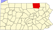
East Troy, Pennsylvania | |
---|---|
Unincorporated community | |
Coordinates: 41°46′12″N76°44′14″W / 41.77000°N 76.73722°W Coordinates: 41°46′12″N76°44′14″W / 41.77000°N 76.73722°W | |
Country | United States |
State | Pennsylvania |
County | Bradford |
Elevation | 974 ft (297 m) |
Time zone | Eastern (EST) (UTC-5) |
• Summer (DST) | EDT (UTC-4) |
Area code(s) | 570 |
GNIS feature ID | 1173887 [1] |
East Troy is an unincorporated community in Bradford County, Pennsylvania, United States. [1]
Bradford County is a county located in the U.S. state of Pennsylvania. As of the 2010 census, the population was 62,622. Its county seat is Towanda. The county was created on February 21, 1810, from parts of Lycoming and Luzerne counties. Originally called Ontario County, it was reorganized and separated from Lycoming County on October 13, 1812, and renamed Bradford County for William Bradford, who had been a chief justice of the Pennsylvania Supreme Court and United States Attorney General.
Pennsylvania, officially the Commonwealth of Pennsylvania, is a state located in the northeastern and Mid-Atlantic regions of the United States. The Appalachian Mountains run through its middle. The Commonwealth is bordered by Delaware to the southeast, Maryland to the south, West Virginia to the southwest, Ohio to the west, Lake Erie and the Canadian province of Ontario to the northwest, New York to the north, and New Jersey to the east.
This Bradford County, Pennsylvania state location article is a stub. You can help Wikipedia by expanding it. |
Interstate 80 (I-80) is an east–west transcontinental freeway in the United States that runs from downtown San Francisco, California, to Teaneck, New Jersey, in the New York City Metropolitan Area. The highway was designated in 1956 as one of the original routes of the Interstate Highway System. Its final segment was opened to traffic in 1986. It is the second-longest Interstate Highway in the United States, following I-90. The Interstate runs through many major cities including Oakland, Sacramento, Reno, Salt Lake City, Omaha, Des Moines, and Toledo, and passes within 10 miles (16 km) of Chicago, Cleveland, and New York City.
Crawford County is a county located in the U.S. state of Pennsylvania. As of the 2010 census, the population was 88,765. Its county seat is Meadville. The county was created on March 12, 1800, from part of Allegheny County and named for Colonel William Crawford.
Troy is a city in the U.S. state of New York and the seat of Rensselaer County. The city is located on the western edge of Rensselaer County and on the eastern bank of the Hudson River. Troy has close ties to the nearby cities of Albany and Schenectady, forming a region popularly called the Capital District. The city is one of the three major centers for the Albany Metropolitan Statistical Area (MSA), which has a population of 1,170,483. At the 2010 census, the population of Troy was 50,129. Troy's motto is Ilium fuit. Troja est, which means "Ilium was, Troy is".
Alba is a borough in Bradford County, Pennsylvania, United States. The population was 157 at the 2010 census.
Burlington Township is a township in Bradford County, Pennsylvania, United States. The population was 791 at the 2010 census. Children residing in the township are assigned to attend the Troy Area School District.
Columbia Township is a township in Bradford County, Pennsylvania, United States. The population was 1,196 at the 2010 census. Children residing in the township are assigned to attend the Troy Area School District.
Granville Township is a township in Bradford County, Pennsylvania, United States. The population was 950 at the 2010 census. Children residing in the township are assigned to attend the Troy Area School District.
Springfield Township is a township in Bradford County, Pennsylvania, United States. The population was 1,124 at the 2010 census. Children residing in the township are assigned to attend the Troy Area School District.
Troy is a borough in Bradford County, Pennsylvania, United States. The population was 1,354 at the 2010 census. Children residing in the borough are assigned to attend the Troy Area School District.
Troy Township is a township in Bradford County, Pennsylvania, United States. The population was 1,645 at the 2010 census. Children residing in the township are assigned to attend the Troy Area School District.
West Burlington Township is a township in Bradford County, Pennsylvania, United States. The population was 696 at the 2010 census. Children residing in the township are assigned to attend the Troy Area School District.
East Troy is a village in Walworth County, Wisconsin, United States. The population was 4,281 at the 2010 census. The village is located southeast of the Town of East Troy. A small portion extends into the adjacent Town of Troy.
New York State Route 7 (NY 7) is a 180-mile (290 km) state highway in New York in the United States. The highway runs from Pennsylvania Route 29 (PA 29) at the Pennsylvania state line south of Binghamton to Vermont Route 9 (VT 9) the Vermont state line east of Hoosick. Most of the road runs along the Susquehanna Valley, closely paralleling Interstate 88 (I-88) throughout that road's length. Portions of the highway route near the cities of Binghamton, Schenectady, and Troy date back to the early 19th century.
East Trenton is a neighborhood located within the city of Trenton in Mercer County, New Jersey, United States. It borders Hamilton Township and is home to a sizable African-American community, besides having small pockets of Latinos and Italians.
East Troy may refer to:
The 65th Pennsylvania House of Representatives District is in Northeastern Pennsylvania and has been represented by Kathy Rapp since 2005.
Frederick C. Sauer was a German-American architect, particularly in the Pittsburgh, Pennsylvania, region of the late 19th and early 20th centuries.
Columbia Cross Roads is an unincorporated community in Bradford County, Pennsylvania, United States. The community is located along Pennsylvania Route 14 3.5 miles (5.6 km) north of Troy. Columbia Cross Roads has a post office with ZIP code 16914.
Granville Summit is an unincorporated community in Bradford County, Pennsylvania, United States. The community is located along Pennsylvania Route 514 4.8 miles (7.7 km) south of Troy. Granville Summit has a post office with ZIP code 16926.