Eaton, Leicestershire

Last updated

Eaton
Eaton St Denis 2.jpg
Saint Denys Church, Eaton
Leicestershire UK location map.svg
Red pog.svg
Eaton
Location within Leicestershire
Population648 (2011 Census)
District
Shire county
Region
Country England
Sovereign state United Kingdom
Post town Grantham
Postcode district NG32
Police Leicestershire
Fire Leicestershire
Ambulance East Midlands
UK Parliament
List of places
UK
England
Leicestershire
52°51′11″N0°49′05″W / 52.853°N 0.818°W / 52.853; -0.818

Eaton is a village and civil parish in Leicestershire, England, situated in the Vale of Belvoir. The population at the 2011 census (including Eastwell and Goadby Marwood) was 648. [1] The civil parish includes nearby Eastwell to the west of the village. Eaton has a church, a village hall and a children's park, but the public house called The Castle and its adjacent shop have closed. [2]

Contents

Natural surroundings

The land surrounding Eaton has at least ten known springs and is the source of the River Devon. It is full of sandstone. The land is also full of iron ore and the area was a famous source of iron,in the past large quarries were formed outside the village supplying two local iron works by rail via the Eaton Branch Railway from around 1884 to 1965. [3] One quarry has since become a woodland area. The railway bridge under which some of the iron was transported is still standing.

Buildings

The church in Eaton is Saint Denys Church, which mostly dates back to the 13th century. Unusually the spire is built of ironstone. [4] The public house in Eaton was The Castle, which served food and was a registered campsite. Eaton still has a village hall.

Local legends

The most famous local legend at Eaton concerns a "phantom cat" that stalks the countryside at night. There have been over 300 recorded sightings of the cat, said to be a black panther, in 2001–2002.[ citation needed ] People believe there must be more than one cat in the area and there have been sightings of dead herons and dead lambs found in trees. There are plenty of hiding places for the cats in large stretches of abandoned railway now covered in trees.

Another local story concerns a 17th-century band of vigilantes in an organisation called Ash Tree Operations, which built a huge underground hideout somewhere in the Eaton countryside. The entrance to this was a hollow ash tree, which led to its name. The band was formed as Eaton had become a popular haunt for criminals from surrounding villages, committing murders and looting houses. It struck violently at criminals in the absence of effective policing.[ citation needed ]

History

The village's name means "farm/settlement on an island". [5] An alternative suggestion is that it means farm on dry ground in a marsh. [6]

The incumbent's reply to the Articles of Inquiry for the Ecclesiastical Revenues Commission in 1832.

Robert Walker, the vicar, gives the population of Eaton as 350 (from the 1831 census). He was admitted in October 1814. There was no curator so he did the duties himself. There was only one church which was capable of accommodating the entire population. The "Glebe House unfit, being a mere cottage and very damp" was occupied by Richard Palmer who rented part of the land, paying £10.4.0 for the lodgings. The annual income of the benefice was stated as £83.6.2, no tithes or corn rents or dividends and any other income. The surplice and other fees amounted to nine or ten shillings. This was a poor living, as the incumbent states: "I expect a decrease of Income in future but cannot speak as to the amount of that decrease because the lands are said to be too high let at present and poor rates are increasing."

Iron ore

Iron ore was quarried in the parish between 1884 [7] and 1965. A mineral branch, known as the Eaton Branch, was built by the Great Northern Railway in 1884 [8] to transport the ore. Its terminus was to the north of the Belvoir Road. Its nearest point to the village was a bridge passing under Stathern Road. The first ore was carried to a railway wharf to the north of that bridge by a narrow-gauge tramway in horse-drawn wagons. The horses on that line were replaced by steam locomotives in 1890. The railway never had a passenger service but occasionally freight other than iron ore was carried. The first ore was dug to the west of this railway to the north of the Stathern Road close to the bridge. [9]

The quarries at the northern end of the Eaton Branch were owned by the Waltham Iron Ore Company, a subsidiary of the Staveley Coal and Iron Company. Ore was transported from these quarries to the Eaton Branch by the narrow-gauge Waltham Iron Ore Tramway, starting in 1884. One of the locomotives that worked on this tramway is preserved at the Irchester Narrow Gauge Railway Museum. [7]

More quarries were opened over the years. The quarries later surrounded the village and except as noted below they were connected with the Great Northern branch railway at various points by standard or narrow gauge tramway. One group of quarries used a tramway that connected to an aerial ropeway which ran to sidings on the railway to the south of the Stathern Road bridge. The ropeway ran from 1914 to 1916 and from 1923 (when it was rebuilt) to 1948.[ citation needed ] Tipping docks were built at the wharf and also one at the branch terminus on the Belvoir Road. A group of quarries to the south and east of the village connected with a narrow-gauge tramway running via Eastwell to the Great Northern and London and North Western Joint Railway near Harby.[ citation needed ]

The ore was dug by hand at first but from 1912 onwards steam diggers were introduced.[ citation needed ] From 1936 onwards these began to be replaced by diesel diggers. The Waltham tramway had steam locomotives from its opening in 1884. One of the tramways had a petrol locomotive from 1929 and a diesel locomotive from 1936.[ citation needed ] From 1946 onwards the tramways began to close and ore was transported from some quarries to the wharf by lorry. The last quarries to close were south of the Stathern Road and west of the railway and close to the Eastwell Road (east of the road). The last loads of ore were transported from these quarries to the railway wharf by lorry in December 1965.[ citation needed ] The Eaton Branch then closed and was lifted.

There was a wooden viaduct on the railway which was filled in with slag from Holwell Ironworks in 1955. The embankment thus made is one of the two main monuments to iron ore quarrying in Eaton, the other being the final face of a quarry close to Eaton Grange which ceased production in 1948. This had been one of the quarries which transported ore via a tramway which connected with the ropeway. Most of the quarries have been landscaped and returned to agricultural use. [9]

Related Research Articles

<span class="mw-page-title-main">Woolsthorpe by Belvoir</span> Village and civil parish in the South Kesteven district of Lincolnshire, England

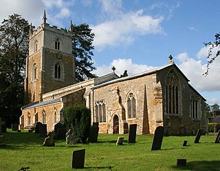
Woolsthorpe by Belvoir, also known as Woolsthorpe is a village and civil parish in the South Kesteven district of Lincolnshire, England. The population of the civil parish at the 2011 census was 415. It is situated approximately 5 miles (8 km) west from Grantham, and adjoins the county border with Leicestershire. The neighbouring village of Belvoir lies on the other side of the border. Grantham Canal is situated 1 mile (1.6 km) to the north-east at its closest point.

Scaldwell is a village and civil parish in the West, Northamptonshire, England.

<span class="mw-page-title-main">Pitsford</span> Village in Northamptonshire, England

Pitsford is a village and civil parish in West Northamptonshire in the United Kingdom. According to 2001 census, the parish's population was 636 people, increasing to 671 at the 2011 census.

<span class="mw-page-title-main">Lamport, Northamptonshire</span> Human settlement in England

Lamport is a village and civil parish in West Northamptonshire, England. The village is on the A508, about 8 miles (13 km) south of Market Harborough and 8 miles (13 km) north of Northampton. Nearby is Lamport Hall. At the time of the 2001 census, the parish's population was 207 people, including Hanging Houghton and increasing to 225 at the 2011 Census.

<span class="mw-page-title-main">Denton, Lincolnshire</span> Village and civil parish in the South Kesteven district of Lincolnshire, England

Denton is a village and civil parish in the South Kesteven district of Lincolnshire, England. The population of the civil parish was 273 at the 2011 census. It is situated approximately 3 miles (5 km) both south-west of Grantham and west from the A1 road.

<span class="mw-page-title-main">Ab Kettleby</span> Village in Leicestershire, England

Ab Kettleby is a village and civil parish in the Melton district of Leicestershire, England, located 3 miles (4.8 km) north of Melton Mowbray, on the A606 road. It had a population of 501 in 2001; at the 2011 census this had increased to 529.

<span class="mw-page-title-main">Waltham on the Wolds</span> Village in Leicestershire, England

Waltham on the Wolds is a village and former civil parish, now in the parish of Waltham on the Wolds and Thorpe Arnold, in the Melton borough of Leicestershire, England. It lies about 5 miles (8.0 km) north-east of Melton Mowbray and 11 miles (17.7 km) south-west of Grantham on the main A607 road. In 1931 the parish had a population of 510. The population of Waltham on the Wolds and Thorpe Arnold was 967 in 2011.

<span class="mw-page-title-main">Sproxton, Leicestershire</span> Human settlement in England

Sproxton is a village and civil parish within the Borough of Melton in Leicestershire, England, close to the border with Lincolnshire. It has approximately 80 occupied dwellings (2021) and a population of 480, rising to 658 at the 2011 census.

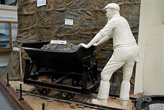
The Kettering Ironstone Railway was an industrial 3 ft narrow gauge railway that served the ironstone quarries around Kettering.

<span class="mw-page-title-main">Knipton</span> Human settlement in England

Knipton is a village and former civil parish, now in the parish of Belvoir, in the Melton district, in the county of Leicestershire, England. It lies about 6 miles (10 km) from the town of Grantham, just off the A607, and 10 miles (16 km) from Melton Mowbray. It borders the Duke of Rutland's estate at Belvoir Castle. Although the village is in Leicestershire, it has a Nottinghamshire postcode and a Lincolnshire (Grantham) STD code. In 1931 the parish had a population of 273. On 1 April 1936 the parish was abolished and merged with Belvoir.

The Great Northern and London and North Western Joint Railway was a British railway line, almost entirely within Leicestershire. Authorised by the same Act of Parliament, the Great Northern Railway Leicester Branch was built, branching from the Joint Line; on the same basis the Newark to Bottesford Line was built. The lines opened progressively between 1879 and 1883. The dominant traffic was iron ore, and the agricultural produce of the area served also generated considerable business. The passenger usage was never heavy, although some unusual through services were attempted at first.

<span class="mw-page-title-main">British quarrying and mining narrow-gauge railways</span> List of quarrying and mining narrow gauge railways in the United Kingdom

Some industrial narrow-gauge railways in the United Kingdom and the Isle of Man were primarily built to serve quarrying, mining, and similar industries. Some of these narrow-gauge railways offered passenger services for employees or workmen, but they did not run public passenger trains. They are listed by the primary industry they served.

<span class="mw-page-title-main">Harston, Leicestershire</span> Village in Leicestershire, England

Harston is a crossroads village and former civil parish, now in the parish of Belvoir, in the Melton district, in Leicestershire, England, near the border with Lincolnshire. The nearest town is Grantham, about 6 miles (10 km) to the north-east. It once contained several quarries for iron ore. Part of the village borders Lincolnshire. In 1931 the parish had a population of 182. On 1 April 1936 the parish was abolished and merged with Belvoir.

<span class="mw-page-title-main">Eastwell, Leicestershire</span> Human settlement in England

Eastwell is a village and ecclesiastical parish in Leicestershire, England.

<span class="mw-page-title-main">Branston, Leicestershire</span> Village in Leicestershire, England

Branston is a village and former civil parish, now in the parish of Croxton Kerrial in the Melton district, in the county of Leicestershire, England. It lies 1 mile (1.6 km) north of the A607 road, 7 miles (11 km) south-west of Grantham and 7 miles north-east of Melton Mowbray, on the southern edge of the Vale of Belvoir, 3 miles (5 km) south-west of Belvoir Castle. Knipton Reservoir is 700 yards (640 m) to the north. In 1931 the parish had a population of 249.

<span class="mw-page-title-main">Irchester Narrow Gauge Railway Museum</span> Railway museum in Irchester, England

The Irchester Narrow Gauge Railway Museum is a small railway museum and metre gauge railway near Irchester, near Wellingborough in Northamptonshire, England.

<span class="mw-page-title-main">Waltham Iron Ore Tramway</span> Industrial tramway in Leicestershire

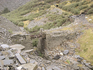
The Waltham Iron Ore Tramway was a 1,000 mm gauge industrial tramway serving the ironstone pits of the Waltham Iron Ore Company, a subsidiary of the Staveley Coal and Iron Company. It was located to the north of the village of Branston in Leicestershire on the edge of the Belvoir Estate. The tramway operated from 1884 until 1958.

<span class="mw-page-title-main">Wellingborough Tramway</span> Narrow-gauge railway in the United Kingdom

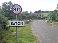
The Eaton Branch Railway was a standard gauge industrial railway built to serve ironstone quarries around the village of Eaton in Leicestershire. It operated from 1884 until 1965.

<i>Nancy</i> (locomotive)

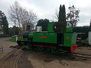
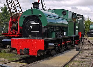
Nancy is a narrow gauge steam locomotive. It was built by Avonside Engine Company in 1908 for industrial service. It was in use until 1961, when it was acquired for preservation. After many years of effort and long storage, it was returned to working order in April 2019, and was then moved to its current owners, the Cavan and Leitrim Railway in Ireland.

References

  1. "Civil Parish population 2011". Neighbourhood Statistics. Office for National Statistics. Archived from the original on 11 October 2016. Retrieved 11 June 2016.
  2. Retrieved 15 November 2020.
  3. Aldworth, Colin (2012). The Nottingham and Melton Railway 1872 - 2012.
  4. Pevsner, Nikolaus; Williamson, Elizabeth (1984). Buildings of Leicestershire and Rutland. Buildings of England (2nd with corrections of 1992 ed.). London: Penguin. p. 149. ISBN   0-14-071018-3.
  5. "Key to English Place-names". kepn.nottingham.ac.uk. Archived from the original on 10 August 2021. Retrieved 26 August 2021.
  6. Mills, AD (1991). A Dictionary of English Place Names. Oxford: Oxford University Press. p. 116. ISBN   0-19-869156-4.
  7. 1 2 Quine, Dan (2016). Four East Midlands Ironstone Tramways Part One: Waltham. Vol. 105. Garndolbenmaen: Narrow Gauge and Industrial Railway Modelling Review.
  8. Turnock, David (2016). An Historical Geography of Railways in Great Britain and Ireland. Routledge. p. 1925. ISBN   978-1-351958-93-6.
  9. 1 2 Tonks, Eric (1992). The Ironstone Quarries of the Midlands Part 9: Leicestershire. Cheltenham: Runpast Publishing. p. 45–145. ISBN   1-870-754-085.

52°51′11″N0°49′05″W / 52.853°N 0.818°W / 52.853; -0.818