Egelsee (Kärnten)

Last updated
Egelsee
Egelsee Karnten 07 2014.jpg
View to the east with Mirnock massif
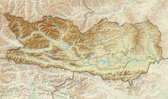
Austria Carinthia relief location map.svg
Red pog.svg
Egelsee
Location Carinthia
Coordinates 46°47′03″N13°33′40″E / 46.7842°N 13.5610°E / 46.7842; 13.5610
Lake type mire lake
Primary outflows to Drava River
Basin  countries Austria
Surface area 9.35 ha (23.1 acres)
Surface elevation650 m (2,130 ft)

Egelsee (formerly also called Ecksee) is a mire lake in Carinthia, Austria. The lake and its environment are part of a protected landscape area.

Geography

Swampy shores, view to east Egelsee Karnten 05 2014.jpg
Swampy shores, view to east

The small is located on the plateau of a hill chain, which stretches between the southern shore of Millstätter See at an elevation of 588 m (1,929 ft) and the lower Drava valley near Spittal an der Drau down to 530 m (1,740 ft). The range on the southwestern rim of the Nock Mountains was honed by the last glacial period ( Würm ), it is about 2 km (1.2 mi) wide and 13 km (8.1 mi) long. The Egelsee on top can be reached via hiking trails through the surrounding forests. Open air bathing is possible.

The mire lake with an area of 9.35 hectares is completely surrounded by floating grass. Due to its location in the midst of a vast moor his water colour is deep brown. The acidic waters are surrounded by quaking bogs, mostly of peat mosses. Sundews, bladderworts, alpenrose, hare's-tail cottongrass, bog-rosemary, and bog bilberry also occur. All stages of bog formation can be observed on Egelsee. The local fauna include cyclops copepods as well as common frogs and water frogs, with large spawn clusters covering the shoreline water surface in spring. Originally there were no fish in this lake.

Swimming at the lake Egelsee mit Steg.jpg
Swimming at the lake

The surrounding landscape conservation area is located in the municipal areas of Seeboden, Spittal and Ferndorf. The shaded southern shore of Lake Millstatt is largely in its natural state, as opposed to the densely settled northern shore, and virtually uninhabited. The historic route from Millstatt Abbey into the Drava Valley - Lake Millstatt was thereby crossed by boat - went some distance to the east past the Egelsee. Remnants of the old flagged stone pathway are still visible.


Related Research Articles

<span class="mw-page-title-main">Dartmoor</span> National park in South West England

Dartmoor is an upland area in southern Devon, South West England. The moorland and surrounding land has been protected by National Park status since 1951. Dartmoor National Park covers 954 km2 (368 sq mi).

<span class="mw-page-title-main">Carinthia</span> State of Austria

Carinthia is the southernmost and least densely populated Austrian state, in the Eastern Alps, and is noted for its mountains and lakes. The main language is German. Its regional dialects belong to the Southern Bavarian group. Carinthian Slovene dialects, forms of a South Slavic language that predominated in the southeastern part of the region up to the first half of the 20th century, are now spoken by a small minority in the area.

<span class="mw-page-title-main">Lake Neusiedl</span> Steppe lake in Central Europe

Lake Neusiedl, or Fertő, is the largest endorheic lake in Central Europe, straddling the Austrian–Hungarian border. The lake covers 315 km2 (122 sq mi), of which 240 km2 (93 sq mi) is on the Austrian side and 75 km2 (29 sq mi) on the Hungarian side. The lake's drainage basin has an area of about 1,120 km2 (430 sq mi). From north to south, the lake is about 36 km (22 mi) long, and it is between 6 km and 12 km wide from east to west. On average, the lake's surface is 115.45 m (378.8 ft) above the Adriatic Sea and the lake is no more than 1.8 m deep.

<span class="mw-page-title-main">Malta, Austria</span> Place in Carinthia, Austria

Malta is a municipality and a village in the district of Spittal an der Drau, in the Austrian state of Carinthia.

<span class="mw-page-title-main">Spittal an der Drau</span> Place in Carinthia, Austria

Spittal an der Drau is a town in the western part of the Austrian federal state of Carinthia. It is the administrative centre of Spittal an der Drau District, Austria's second largest district (Bezirk) by area.

<span class="mw-page-title-main">Lake Ossiach</span> Lake in Carinthia, Austria

Lake Ossiach is a lake in the Austrian state of Carinthia. It is the state's third largest lake after Lake Wörth and Lake Millstatt.

Bezirk Spittal an der Drau is an administrative district (Bezirk) in the state of Carinthia, Austria.

<span class="mw-page-title-main">Noric Alps</span> Various mountain ranges of the Eastern Alps

The Noric Alps is a collective term denoting various mountain ranges of the Eastern Alps. The name derives from the ancient Noricum province of the Roman Empire on the territory of present-day Austria and the adjacent Bavarian and Slovenian area.

<span class="mw-page-title-main">Millstatt am See</span> Place in Carinthia, Austria

Millstatt am See is a market town of the Spittal an der Drau District in Carinthia, Austria. The traditional health resort and spa town on Lake Millstatt is known for former Benedictine Millstatt Abbey, founded about 1070.

<span class="mw-page-title-main">Millstätter See</span> Glacial lake in Carinthia

Lake Millstatt is a lake in Carinthia, Austria.

<span class="mw-page-title-main">Bad Kleinkirchheim</span> Place in Carinthia, Austria

Bad Kleinkirchheim is a municipality and spa town in the district of Spittal an der Drau, in Carinthia, Austria.

<span class="mw-page-title-main">Reißeck</span> Place in Carinthia, Austria

Reißeck is a municipality in the district of Spittal an der Drau in Carinthia, Austria.

<span class="mw-page-title-main">Weissensee (Carinthia)</span> Lake in Carinthia, Austria

The Weissensee is a lake in the Austrian state of Carinthia within the Gailtal Alps mountain range. The highest situated Carinthian bathing lake shares its name with the municipality of Weissensee on the northern and southern shore.

<span class="mw-page-title-main">Obermillstatt</span>

Obermillstatt is a village and cadastral community in the municipality of Millstatt in Spittal an der Drau District, in Carinthia, Austria.

<span class="mw-page-title-main">Hydrology of Hungary</span>

The hydrology of Hungary, is mostly determined by Hungary's lying in the middle of the Carpathian Basin, half surrounded by the Carpathian Mountains. All parts of the country have some outflow. All surface water gravitates towards its southern center, and from there, is united in the Danube, which flows into the Black Sea. The whole of Hungary lies within the Danube drainage basin.

<span class="mw-page-title-main">Gurktal Alps</span> Mountain range in the Central Eastern Alps in Austria

The Gurktal Alps is a mountain range in the Central Eastern Alps in Austria which is named after the valley of the Gurk river. The range stretches west to Lake Millstatt and east to Neumarkter Sattel. The highest peak is Eisenhut at 2,441m .

<span class="mw-page-title-main">Gailtal Alps</span>

The Gailtal Alps, is a mountain range of the Southern Limestone Alps in Austria. It rises between the River Drava (Drau) and the Gail valley and through the southern part of East Tyrol. Its western group called "Lienz Dolomites", is sometimes counted as part of this range and sometimes seen as separate.

<span class="mw-page-title-main">Frauenwinkel</span> Mire landscape in Switzerland

Frauenwinkel is a mire landscape in Switzerland, situated at the Seedamm area on Zürichsee lakeshore in the municipality of Freienbach in the Canton of Schwyz.

<span class="mw-page-title-main">1st Carinthian Fishing Museum</span>

The 1st Carinthian Fishing Museum is a museum in the western bay of Lake Millstatt in the district of Wirlsdorf in Seeboden, Carinthia, Austria, established in 1980. After a temporary closure from 2009 to mid-2011, the museum is now open again.