Ciudad del Carmen or Carmen is a city in the southwest of the Mexican state of Campeche. Ciudad del Carmen is located at 18.63°N 91.83°W on the southwest of Carmen Island, which stands in the Laguna de Términos on the coast of the Gulf of Mexico. As of 2010, Ciudad del Carmen had a population of 169,466, up from the 2005 census of 154,197. In July 2006, Ciudad del Carmen celebrated its 150th anniversary as a city.
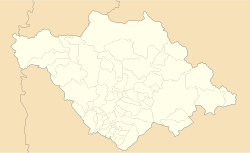
Coatepec Harinas is one of 125 municipalities in the State of Mexico, Mexico. The municipal seat is the town of Coatepec Harinas. The original name is "Coauhtepetl" which means 'serpent hill' in Náhuatl. Around 1825 because of a boom in flour production, the name "Harinas" was added.

Campeche, officially Estado Libre y Soberano de Campeche, is one of the 31 states which, with Mexico City, make up the 32 Federal Entities of Mexico. Located in southeast Mexico, it is bordered by the states of Tabasco to the southwest, Yucatán to the northeast, Quintana Roo to the east, by Petén department of Guatemala to the south and by the Orange Walk District of Belize to the southeast. It has a coastline to the west with the Gulf of Mexico. The state capital, also called Campeche, was declared a World Heritage Site in 1997. The formation of the state began with the city, which was founded in 1540 as the Spanish began the conquest of the Yucatán Peninsula. The city was a rich and important port during the colonial period, but declined after Mexico's independence. Campeche was part of the province of Yucatán but split off in the mid-19th century, mostly due to political friction with the city of Mérida. Much of the state's recent economic revival is due to the discovery of petroleum offshore in the 1970s, which has made the coastal cities of Campeche and Ciudad del Carmen important economic centers. The state has important Mayan and colonial sites; however, these are not as well-known or visited as others in the Yucatán.
Campeche is a state on the Yucatán Peninsula in Mexico that is divided into thirteen municipalities. According to the 2020 Mexican census, Campeche is the third least populous state with 928,363 inhabitants and the 17th largest by land area spanning 57,693.59 square kilometres (22,275.62 sq mi).

San Ángel is a colonia (neighborhood) located in the southwest of Mexico City in Álvaro Obregón borough. Historically it was a rural community called Tenanitla in the pre-Hispanic period. Its current name is derived from the El Carmen monastery school called San Ángel Mártir. It remained a rural community centered on the monastery until the 19th and 20th centuries when the monastery closed and the area joined the urban sprawl of Mexico City. The area still contains many historic buildings, and El Carmen is one of the most visited museums in the city. Its annual flower fair, Feria de las Flores , has been held since 1856.

Ixtapaluca is a city and a municipality in the eastern part of the State of Mexico in Mexico. It lies between Mexico City and the western border of the state of Puebla. The name Ixtapaluca means "Where the salt gets wet".
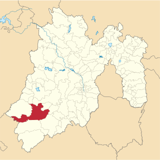
Tejupilco is a municipality in the State of Mexico, Mexico, located approximately 100 kilometres (62 mi) southwest of the state capital Toluca, along Federal Highway 134. Its municipal seat is Tejupilco de Hidalgo. The municipality has a total area of about 1,327 km2 (512 sq mi), with a contrasting topography ranging from deep ravines and canyons to high ridges; the highest elevation within the municipality reaches some 1,117 metres (3,660 ft) asl. The 2005 census recorded a population of 62,547 inhabitants.
Temascalcingo is one of 125 municipalities in the State of Mexico, Mexico. The municipal seat is the town of Temascalcingo de José María Velasco. It is located in the northwest of the state. The temazcal was very common in Temascalcingo. The name Temascalcingo has its roots in Nahuatl. It means place of the little temazcal. The town is one of the "Pueblo con Encanto" of the State of Mexico.

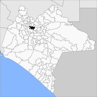
Carmen is one of the 13 municipalities in the Mexican state of Campeche. It is situated at the south-west of the state, on and around the Laguna de Términos. The municipal seat and largest settlement is Ciudad del Carmen. As of 2015, the population was 248,303.

Huixtán is a town and municipality in the Mexican state of Chiapas in southern Mexico. In the Nahuatl language, Huixtán means "the place of the prickles".
Jitotol is a town and municipality in the Mexican state of Chiapas in southern Mexico.

Reforma is a city and municipality in the Mexican state of Chiapas in southern Mexico.

San Luis Acatlán is a municipality in the Mexican state of Guerrero. The municipal seat lies at San Luis Acatlán. The municipality covers an area of 704.4 km².
Xochistlahuaca Municipality is a municipality in the Mexican state of Guerrero. The municipal seat lies at Xochistlahuaca. The municipality covers an area of 321.1 km².
Soyaniquilpan de Juárez is a municipality in the State of Mexico in Mexico. The municipal seat is San Francisco Soyaniquilpan. The municipality covers an area of 140.77 km².

San Salvador Huixcolotla is a town and municipality in the Mexican state of Puebla in southeastern Mexico that may be best known as the birthplace of papel picado. San Salvador is of Spanish origin and translates to "Holy Savior" and Huixcolotla is Nahuatl for "place of the curved spines".

Zacatlán Municipality is a municipality in the Mexican state of Puebla in south-eastern Mexico. Its administrative centre is the city of Zacatlán.

Santa Ana Nopalucan is a town and its surrounding municipality in the Mexican state of Tlaxcala.
Guaymas Municipality is a municipality in the Mexican state of Sonora in north-western Mexico. In 2015, the municipality had a total population of 158,046. The municipal seat is the city of Guaymas.

An alhóndiga or almudí, almudín, alholí, public house or neighbors' market was formerly an establishment where grain was sold, bought and even stored, whose purpose was to help the neighbors and mainly the farmers in times of shortage. It is historically equivalent or derived from the caravanserais of the Muslim world.