Dzitbalché is a large town in the extreme northern part of the Mexican state of Campeche. It is located at 20.32°N 90.05°W and serves as the municipal seat for the municipality of the same name. As of 2010, Dzitbalché had a population of 11,686, up from 10,951 at the 2005 census, making it the sixth-largest community in the state. Before the creation of the municipality of Dzitbalché on 1 January 2021, it was the second-largest community in the municipality of Calkiní.
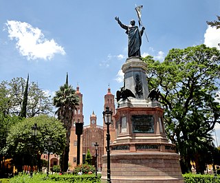
Dolores Hidalgo is the name of a city and the surrounding municipality in the north-central part of the Mexican state of Guanajuato.
Ciudad Frontera is a town in the northern Mexican state of Coahuila. It is in the east-central part of the state, just west of the city of Monclova. It is located in the state's central region (Región Centro).

La Paz is a municipality in the State of Mexico, Mexico, with its municipal seat in the town of Los Reyes Acaquilpan. It is located on the dividing line between Mexico State and the eastern edge of the Federal District and is part of the Greater Mexico City area. The area was part of a region called "Atlicpac" which in Náhuatl means 'above or at the edge of water.' The current city's/municipality's glyph symbolizes water.

Cuautitlán, is a municipality in the State of Mexico, just north of the northern tip of the Federal District within the Greater Mexico City urban area. The city of Cuautitlán is the municipal seat and makes up most of the municipality. The name comes from Nahuatl and means 'between the trees.'

Comalcalco is a city located in Comalcalco Municipality about 45 miles (60 km) northwest of Villahermosa in the Mexican state of Tabasco. Near the city is the Pre-Columbian Maya archaeological site of Comalcalco. The literal English translation of "Comalcalco" is "In the house of the comals". A comal is a pan used to prepare food.

Apizaco is a city in Apizaco Municipality located near the geographic center of the Mexican state of Tlaxcala, approximately 25 minutes by car from the state's capital city of Tlaxcala. Those seeking to reach the port of Veracruz by railroad from Mexico City must travel through Apizaco. The city began because of its location on this railroad.

Ciudad Nicolás Romero is the largest city and municipal seat of the municipality of Nicolás Romero in State of Mexico, Mexico. It is located 58 km from the city of Toluca, the state capital and lies in the north-central part of the state, just northwest of the Federal District. The seat/municipality's current name is to honor Nicolás Romero, who fought for Benito Juárez during the Reform War and the French intervention in Mexico. He was executed there by the French. The town adopted this name in 1898. The area was settled by the Otomi and named Azcapotzaltongo by the Aztecs after conquering it. During colonial times, it was known as San Pedro Azcapotzaltongo. It was then called Monte Bajo from 1821 to 1898, when the current name was adopted. Both the municipality and city are commonly referred to as Nicolás Romero.
Amozoc de Mota is a city located in the Mexican state of Puebla, Mexico. Its borders are in the north, the Malintzin volcano; in the south, the "Sierra de Amozoc"; in the west, the Acajete municipal seat; and in the west, the capital of the State Puebla city. Amozoc city is the seventh largest in the State, of Puebla, with a 2005 census population of 60,517 inhabitants.
San Martín Texmelucan de Labastida is a city in the west-central part of the state of Puebla in Mexico, adjacent to the southwest corner of the state of Tlaxcala. It is the municipal seat of the municipality of San Martín Texmelucan. The city is the fifth-largest in the state of Puebla, with a 2020 census population of 155,738 inhabitants.

Cárdenas is the second-largest city in the Mexican state of Tabasco, in southeastern Mexico. At the census of 2005 the city had a population of 79,875 inhabitants, while the municipality had 219,563 inhabitants. There are numerous smaller communities in the municipality, but the largest are Sánchez Magallanes and Campo Magallanes. The area of the municipality is 2,112 km².

Chicoloapan de Juárez is the municipal seat and largest city in the municipality of Chicoloapan in State of Mexico, Mexico. It is located in the eastern part of the state, just east of Chimalhuacán and northeast of the Federal District, within the Greater Mexico City urban area.
Matamoros is a city located in the southwestern part of the Mexican state of Coahuila; it serves as the seat of the surrounding municipality of the same name. It lies directly east of the larger city of Torreón and is a part of the Comarca Lagunera, a larger metropolitan area that includes the municipality of Torreón in Coahuila in addition to the municipalities of Gómez Palacio and Lerdo in the adjacent state of Durango.
San Pedro is a city located in the southwestern part of the state of Coahuila in Mexico. San Pedro lies east-northeast of the city of Torreón and serves as the seat of the surrounding municipality of the same name.

Izúcar de Matamoros is a city in Izúcar de Matamoros Municipality located in the southwestern part of the Mexican state of Puebla. The city serves as the municipal seat of the municipality. At the census of 2005 the city had a population of 41,042 inhabitants, while the municipality had a population of 69,413. The municipality has an area of 514.11 km², and stands at 1100 m above sea level. Its largest other communities are the towns of La Galarza and San Juan Raboso. It has many sights like the portales, and Santo Domingo, the biggest church in the city.

Victoria is a Mexican city located in the Northeast region of the state of Guanajuato, within the Sierra Gorda range. The municipality has an area of 1009.437 square kilometres and is bordered to the north by the state of San Luis Potosí, to the east by Xichú, to the south by Santa Catarina and Doctor Mora, and to the west by San Luis de la Paz. The municipality had a population of 17,764 inhabitants according to the 2005 census.

Armería is a municipality in the south-central part of the Mexican state of Colima. Ciudad de Armería is a city and the seat of Armería municipality. The municipality reported 29,599 inhabitants in the 2015 census and has an area of 341.60 km². Its municipal seat is Ciudad de Armería.

Calvillo is a municipality in the Mexican state of Aguascalientes. The city of Calvillo, the second largest in the state, serves as the municipal seat. It is located to the western part of the state, at about 52 kilometers of the city of Aguascalientes. It stands at 21°51′N102°43′W in the southwestern corner of the state. It is bounded by Jalisco and Zacatecas. The municipality, which has an area of 931.26 km², reported a population of 54,136 by 2010. The town of Ojocaliente is another significant community in the municipality. Calvillo is one of the richest, most prosperous municipalities in Aguascalientes.
San Matías Tlalancaleca is a town and municipality in the Mexican state of Puebla in south-eastern Mexico. The population of San Matias Tlalancaleca was 20,974 inhabitants in 2015.

Tlaxco is a municipality in the Mexican state of Tlaxcala in south-eastern Mexico.