The El Cielo Biosphere Reserve (Reserva de la Biosfera El Cielo in Spanish) is located in the Sierra Madre Oriental in the southern part of the Mexican state of Tamaulipas near the town of Gómez Farias. The reserve protects the northernmost extension of tropical forest and cloud forest in Mexico. It has an area of 144,530 hectares (357,100 acres; 558.0sqmi) made up mostly of steep mountains rising from about 200 metres (660ft) to a maximum altitude of more than 2,300 metres (7,500ft).[1]
The state of Tamaulipas protected the area in 1985 and in 1987 it was formally recognized as a biosphere reserve by UNESCO's Man and the Biosphere Programme.[2]
History
The El Cielo area attracted little attention until the 1930s. In 1935, A Canadian farmer and horticulturalist named John William Francis (Frank, Francisco, or Pancho) Harrison established a homestead he named Rancho El Cielo at 1,140 metres (3,740ft) elevation in the cloud forest. Noted ornithologist George Miksch Sutton began fieldwork in Mexico in the late 1930s,[3] and by 1941 Sutton and Olin Sewall Pettingill Jr. embarked on a series of extended stays in the Gómez Farias region and found their way to Harrison's small ranch followed by a succession of ornithological publications.[4][5][6] Sutton's protégé, Paul S. Martin also conducted extensive fieldwork in the region from 1948 to 1953, publishing herpetological studies[7][8] that culminated with his Biogeography of Reptiles and Amphibians in the Gómez Farias Region, Tamaulipas, Mexico,[9] considered by some to be one of the finer examples of a biogeography in any region or discipline, "a classic treatise in historical biogeography".[10] Extensive logging and roads penetrated the area in the 1950s. In 1965, to protect the ecosystem, Harrison transferred his land to a non-profit corporation in cooperation with Texas Southmost College and the Gorgas Science Foundation. In 1966, Harrison was murdered in a land dispute with local farmers.[11]
Harrison's farm is now the El Cielo Biological Research Center (or Rancho del Cielo). In 1983, the Gorgas Science Foundation established Rancho El Cielito by purchasing land along the Sabinas River, just outside the reserve, to preserve part of a riparian ecosystem.[12]
Geography
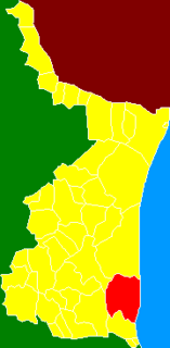
A map of El Cielo Biosphere Reserve in Tamaulipas, Mexico.
The 144,530-hectare (357,100-acre; 558.0sqmi) reserve has two core areas in which most human travel and exploitation are prohibited. One, 7,844 hectares (19,380 acres; 30.29sqmi) in area, protects tropical forests while the larger core area of 28,674 hectares (70,850 acres; 110.71sqmi) includes a cross section of the altitudes and climates of the area, especially the cloud forest. The remainder of the reserve is a buffer zone in which human activities, including limited logging, is permitted. Several communities within the reserve offer facilities for visitors and are reachable by road.[13] An ecological interpretive center is reached by paved road a few miles west of the town of Gómez Farías. The interpretive center, located at an elevation of 360 metres (1,180ft) offers good views of the tropical forest and facilities for visitors.[14]
The reserve occupies portions of four Mexican municipalities in the state of Tamaulipas: Jaumave, Llera de Canales, Gómez Farías, and Ocampo. Within it are 26 ejidos (hamlets with communal land) and about 8,000 hectares (20,000 acres; 31sqmi) of agricultural land used mostly to cultivate corn, beans, and rice.[1] The principal access is a road, initially paved, from the town of Gomez Farias into the interior and higher elevations. The community of Alta Cima (also known as Altas Cimas), at an elevation of 910 metres (2,990ft) has modest lodging and restaurants for visitors. Camping is allowed.
The highest point in the reserve is 7,719 feet (2,353m) located at 23 14N, 99 30W.[14] The lowest elevations are about 200 metres (660ft) at the eastern, northern, and southern boundaries. The reserve is characterized by steep, north-south trending mountain ranges, eastern extensions of the Sierra Madre Oriental, made up of limestone. Typical of karst topography, caves, sinkholes, and rock outcrops are common.[2]
Several distinct vegetation types are found in the reserve. Vegetation in the drier northern and western portions of the reserve up to an elevation of 1,600 metres (5,200ft) consists of desert and semi-desert shrublands, the montane Tamaulipan matorral and the lowland Tamaulipan mezquital. Shrubs and small trees generally do not exceed 5 metres (16ft) in height except in riparian locations. Annual precipitation in the shrublands is less than 1,000 millimetres (39in).[15]
In the eastern part of the reserve, sub-tropical semi-deciduous forests (Veracruz moist forests) are found at elevations of from 200 metres (660ft) and 800 metres (2,600ft) above sea level. The closed canopy forests averages about 20 metres (66ft) in height. Annual precipitation of this zone is usually from 1,100 millimetres (43in) to more than 1,800 millimetres (71in).[16]
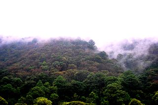
The principal reason for the establishment of El Cielo was the prevalence of cloud forests, distinguished by heavy precipitation, foggy conditions, and abundant mosses and fungi, at elevations of 800 metres (2,600ft) to 1,400 metres (4,600ft). The El Cielo cloud forests receive precipitation of about 2,500 millimetres (98in) annually. The closed canopy forests reach a height of about 30 metres (98ft).
Oak forests, (Sierra Madre Oriental pine-oak forests), mixed oak-pine forest, and pine forests are found at elevations of 700 metres (2,300ft) to the top of highest summits in the reserve. These forested highland areas are drier than the cloud forests with an average precipitation of 850 millimetres (33in) annually.[1][17]
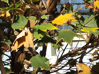
All of the vegetation types experience a wet season from May to October and a dry season from November to April. More than 1,000 species of plants have been recorded from the cloud forests consisting of 56 percent tropical species, 20 percent temperate, 19 percent cosmopolitan, and 5 percent other. Included are species associated with the temperate climate of the eastern United States such as maple (Acer skutchii), hickory (Carya ovata), hornbeam (Carpinus tropicalis), and redbud (Cercis canadensis).[2]
A botanical garden and arboretum is located in Alta Cima at an elevation of 800 metres (2,600ft).[18]
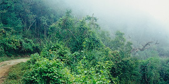
The road into the cloud forest at El Cielo Biosphere Reserve, Municipality of Gómez Farías, Tamaulipas, Mexico (16 April 2001)
The few roads in the cloud forest of El Cielo Biosphere Reserve are suitable for four-wheel drive vehicles only (12 August 2004).
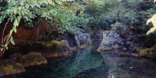
Mountain streams disappear into fissures and sinkholes then reappear and disappear again throughout the karstic environment (12 August 2004).
Fauna
Mammals: Six species of cats, none abundant, are found in the reserve: jaguar, mountain lion, ocelot, margay, jaguarundi, and bobcat. A small population of black bears is also present. At least 255 species of birds are resident in the reserve and more than 175 migratory species have been recorded. Both birds and mammals are a mixture of temperate and tropical species.[1]
The large cats, jaguars and mountain lions, are generally regarded favorably by the people living in the reserve. Mountain lions are more often seen in the cloud forests and the higher elevations of the reserve, while jaguars are more common in the lower-elevation tropical forests.[19] Camera traps set out in tropical forests photographed eight male, female, and juvenile jaguars in a survey area of 135 square kilometres (52sqmi). The investigators estimated a density of six jaguars per 100 square kilometres (39sqmi). The principal prey animals of the jaguar are the lowland paca, Central American red brocket deer, white-tail deer, Virginia opossum, collared peccary, racoon, and great curassow. In addition the jaguar sometimes preys on domestic animals.[20]
Reptiles: Although Morelet’s crocodile (Crocodylus moreletii) and several species of turtles occur in Tamaulipas, they are largely absent from the mountain slopes of El Cielo, however, the Mexican box turtle (Terrapene mexicana) has been recorded at lower elevation in the area. Paul Martin recorded 24 species of lizards and 44 snakes. Lizards include lower elevation species like the casque-headed lizard (Laemanctus serratus), Mexican spiny-tailed iguana (Ctenosaura acanthura), and rainbow ameiva (Holcosus amphigrammus). Higher elevations support populations of banded arboreal alligator lizard (Abronia taeniata), minor spiny lizard (Sceloporus minor), Dice’s short-nosed skink (Plestiodon dicei), Madrean tropical night lizard (Lepidophyma sylvaticum), and the flathead knob-scaled lizard (Xenosaurus platyceps).[9]
The climate of Gómez Farías, to the east, is typical of the lower and wetter elevations of the reserve. Higher elevations are substantially cooler and precipitation declines rapidly on the western slopes of the mountains. The Sierra Madre Oriental create a rain shadow effect. The town of Jaumave, Tamaulipas at the northwestern entrance to the reserve receives only 17.9 inches (450mm) of precipitation annually and has a semi-arid, near-desert climate. Freezing temperatures are rare at the lower elevations of El Cielo, but common in winter at elevations of more than 1,000 metres (3,300ft)
Climate data for Gomez Farias, Tamaulipas. 23 03 N, 99 09W. Elevation: 327 metres (1,073ft)
Tamaulipas, officially the Free and Sovereign State of Tamaulipas, is a state in the northeast region of Mexico; one of the 31 states which, along with Mexico City, comprise the 32 Federal Entities of Mexico. It is divided into 43 municipalities.
The Mexican blind lizard is a species of legless lizard in the family Dibamidae, and the only species in the genus Anelytropsis. It is endemic to Mexico. They look like Amphisbaenia, but are in fact, only distantly related.
The Sierra Madre Oriental is a mountain range in northeastern Mexico. The Sierra Madre Oriental is part of the American Cordillera, a chain of mountain ranges (cordillera) that consists of an almost continuous sequence of mountain ranges that form the western "backbone" of North America, Central America, South America, and Antarctica.
El Cerro del Aripo, at 940 metres (3,084 ft), is the highest point in the Republic of Trinidad and Tobago. It is part of the Aripo Massif and is located in the Northern Range on the island of Trinidad, northeast of the town of Arima.
The Sierra Nevada de Santa Marta is an isolated mountain range in northern Colombia, separate from the Andes range that runs through the north of the country. Reaching an elevation of 5,700 m (18,700 ft) just 42 km (26 mi) from the Caribbean coast, the Sierra Nevada is the highest coastal range in the tropics, and one of the highest coastal ranges in the world, being 250 metres (820 ft) shorter than the Saint Elias Mountains in Canada. The Sierra Nevada encompasses about 17,000 km2 (6,600 sq mi) and serves as the source of 36 rivers. The range is in the Departments of Magdalena, Cesar and La Guajira.
The Sierra de la Laguna is a mountain range at the southern end of the Baja California Peninsula in Mexico, and is the southernmost range of the Peninsular Ranges System.
Aldama is a municipality of the northeastern Mexican state of Tamaulipas. According to the census of 2010, the municipality had an area of 3,672 square kilometres (1,418 sq mi) and a population of 29,470, including the town of Aldama with a population of 13,661.
Villa's gray shrew is a shrew native to northeastern Mexico, where it is called musaraña.
The graceful splayfoot salamander, also known as the graceful flat-footed salamander, is a species of salamander in the family Plethodontidae. It is endemic to the Tamaulipas state in northeastern Mexico. Its type locality is near Gómez Farías, Tamaulipas.
Aquiloeurycea scandens, commonly known as the Tamaulipan false brook salamander, is a species of salamander in the family Plethodontidae. It is endemic to Mexico and known from the El Cielo Biosphere Reserve in southern Tamaulipas. There are also reports from San Luis Potosí and Coahuila, but these may well refer to other, as yet unnamed species.
The Veracruz moist forests is a tropical moist broadleaf forests ecoregion in eastern Mexico.
The Sierra Madre Oriental pine–oak forests are a Temperate broadleaf and mixed forests ecoregion of northeastern and Central Mexico, extending into the state of Texas in the United States.
The Tamaulipan mezquital is a deserts and xeric shrublands ecoregion in the southern United States and northeastern Mexico. It covers an area of 141,500 km2 (54,600 sq mi), encompassing a portion of the Gulf Coastal Plain in southern Texas, northern Tamaulipas, northeastern Coahuila, and part of Nuevo León.
The Central American pine–oak forests is a tropical and subtropical coniferous forests ecoregion in the mountains of northern Central America and Chiapas state in southern Mexico.
Gómez Farías Municipality is a municipality located in the Mexican state of Tamaulipas. The seat of government for the municipality is the town Gómez Farías. Gómez Farías Municipality has an area of 433 square kilometres (167 sq mi) and a population in 2010 of 8,786. The town of Gómez Farías had a population of 883 in 2010. 23,124 hectares of the municipal area is included in the El Cielo Biosphere Reserve.
Llera de Canales is a municipality located in the Mexican state of Tamaulipas. Also called Llera, the municipality has an area of 2,307 square kilometres (891 sq mi) and a 2010 population of 17,333. The population of the town of Llera is 4,148. Llera was founded December 25, 1748 and later renamed Llera de Canales.
The Sierra de Tamaulipas is an isolated, semi-tropical mountain range in the Mexican state of Tamaulipas. Its highest point is 1,260 m (4,130 ft). There are no cities or towns in the Sierra and the small population is largely agricultural. The higher elevations of the Sierra have forests of oak and pine, contrasting with the semi-arid brush that dominates at lower altitudes. Several archaeological sites establish that the Sierra de Tamaulipas was the northern outpost of the agricultural Mesoamerican peoples of eastern Mexico.
Sierra de San Carlos, also known as the Sierra Chiquita, is an isolated mountain range in the state of Tamaulipas, Mexico. The climate is semi-arid. The highest point is Cerro El Hongo with an elevation of 1,786 metres (5,860 ft) at a location of 24° 34′ 20″ North Latitude and 99° 04′ 24″ West Longitude. Most of the San Carlos range is much lower, averaging 600 metres (2,000 ft) to 800 metres (2,600 ft) in elevation.
Aquiloeurycea is a genus of salamanders in the family Plethodontidae. They are endemic to Mexico. The genus corresponds to the former "Pseudoeurycea cephalica species group", which was established in order to preserve Ixalotriton and Bolitoglossa while avoiding paraphyly of Pseudoeurycea.
Acer skutchii, called the cloud forest sugar maple, Guatemalan maple, Mexican sugar maple or Skutch maple, is a species of flowering plant in the genus Acer, native to Mexico and Guatemala. It is considered by some authorities to be a subspecies of the sugar maple, Acer saccharum subsp. skutchii.
↑ Sutton, George Miksch and Thomas D. Burleigh. (1939). A list of birds observed on the 1938 Semple Expedition to northeastern Mexico. Louisiana State University Museum of Zoology, Occasional Paper No. 3: 1-46.
1 2 Sutton, George Miksch and Olin Sewall Pettingill Jr. (1942). Birds of the Gomez Farias Region, Southwestern Tamaulipas. The Auk, 59(1): 1-34.
↑ Sutton, George Miksch. (1951). Mexican Birds: First Impressions Based Upon an Ornithological Expedition to Tamaulipas, Nuevo Leon, and Coahuila with an Appendix Briefly Describing all Mexican Birds. University of Oklahoma Press
↑ Sutton, G. M. 1972. At a Bend in a Mexican River. Paul S. Eriksson, Inc. Publisher, New York, New York xvii, 184. ISBN0-8397-0780-0
↑ Martin, Paul S. (1955). Zonal Distribution of Vertebrates in a Mexican Cloud Forest. American Naturalist 89: 347-361.
↑ Martin, Paul S. (1955). Herpetological Records from the Gómez Farias Region of Southwestern Tamaulipas, Mexico. Copeia 1955(3): 173-180.
1 2 3 4 Martin, Paul S. 1958. A Biogeography of Reptiles and Amphibians in the Gómez Farias Region, Tamaulipas, Mexico. Miscellaneous Publications, Museum of Zoology University of Michigan, 101: 1-102.
↑ Adler, Kraig. (2012). Contributions to the History of Herpetology, Vol. III. Contributions to Herpetology Vol. 29. Society for the Study of Amphibians and Reptiles. 564 pp. ISBN978-0-916984-82-3
↑ Howell, S. N. G. and S. Webb. (1995). A Guide to the Birds of Mexico and Northern Cantral America. Oxford University Press. Oxford. xvi, 851 pp. ISBN0-19-854012-4
↑ Farr, William L., Pablo A. Lavin-Murcio, and David Lazcano. (2007). New Distributional Records for Amphibians and Reptiles from the State of Tamaulipas, Mexico. Herpetological Review 38(2): 226-233.
↑ Miller, R. R., W. L. Minckley, and S. M. Norris. (2005). Freshwater Fishes of Mexico. University of Chicago Press. Chicago, Illinois. xxv, 490 pp. ISBN0-226-52604-6
↑ García de León, Francisco J., Delladira Gutiérrez Tirado, Dean A. Hendrickson, and Héctor Espinosa Pérez (2005). Fishes of the Continental Waters of Tamaulipas: Diversity and Conservation Status. In Jean-Luc E. Cartron, Gerardo Ceballos, and Richard S. Felger (eds.). Biodiversity, Ecosystems, and Conservation in Northern Mexico. Oxford University Press, Inc. New York, N. Y. xvi, 496 pp. ISBN0-19-515672-2
This page is based on this Wikipedia article Text is available under the CC BY-SA 4.0 license; additional terms may apply. Images, videos and audio are available under their respective licenses.