
San Antonio Del Tule is a town in the northern Mexican state of Chihuahua. The town serves as the seat of government for the surrounding El Tule Municipality which shares its name. As of 2010, the town had a population of 811. [1]
San Antonio Del Tule is a town in the northern Mexican state of Chihuahua. The town serves as the seat of government for the surrounding El Tule Municipality which shares its name. As of 2010, the town had a population of 811. [1]

Asientos is a municipality in the Mexican state of Aguascalientes. It stands at 22°14′N102°05′W. The town of Real de Asientos serves as the municipal seat for the surrounding municipality of Asientos.

El Árbol del Tule is a tree located in the church grounds in the town center of Santa María del Tule in the Mexican state of Oaxaca, approximately 9 km (6 mi) east of the city of Oaxaca on the road to Mitla. It is a Montezuma cypress, or ahuehuete. It has the stoutest tree trunk in the world. In 2001, it was placed on a UNESCO tentative list of World Heritage Sites, but was removed from the list in 2013.

Floyd Lamb Park at Tule Springs is a 2,040-acre (830 ha) park in Las Vegas, Nevada. The park is centered on Tule Springs, a series of small natural spring-fed lakes that form an oasis in this part of the Mojave Desert. One of the larger urban retreats in the Las Vegas Valley, Tule Springs was once considered to be far out of town but is now encroached by development. The park includes the Tule Springs Ranch, Tule Springs Archaeological Site, Tule Springs Wash and four ponds available for fishing.

Schoenoplectus acutus, called tule, common tule, hardstem tule, tule rush, hardstem bulrush, or viscid bulrush, is a giant species of sedge in the plant family Cyperaceae, native to freshwater marshes all over North America. The common name derives from the Nāhuatl word tōllin, and it was first applied by the early settlers from New Spain who recognized the marsh plants in the Central Valley of California as similar to those in the marshes around Mexico City.

Nahuizalco is a municipality in the Sonsonate department of El Salvador. It lies on the "flowers route", 9 km from Sonsonate and 74 km from San Salvador, at 540 m above sea level on the southern part of the Apaneca-Ilamatepec mountain range. Per the population and housing census of 2007, Nahuizalco has 49,081 residents.

The Tule River, also called Rio de San Pedro or Rio San Pedro, is a 71.4-mile (114.9 km) river in Tulare County in the U.S. state of California. The river originates in the Sierra Nevada east of Porterville and consists of three forks, North, Middle and South. The North Fork and Middle Fork meet above Springville. The South Fork meets the others at Lake Success. Downstream of Success Dam, the river flows west through Porterville. The river used to empty into Tulare Lake, but its waters have been diverted for irrigation. However, the river does reach Tulare Lake during floods. Tulare Lake is the terminal sink of an endorheic basin that historically also received the Kaweah and Kern Rivers as well as southern distributaries of the Kings.

Cabeza Prieta National Wildlife Refuge (CPNWR) is located in southwestern Arizona in the United States, along 56 miles (90 km) of the Mexico–United States border. It is bordered to the north and to the west by the Barry M. Goldwater Air Force Range, to the south by Mexico's El Pinacate y Gran Desierto de Altar Biosphere Reserve, to the northeast by the town of Ajo, and to the southeast by Organ Pipe Cactus National Monument.

Santa María del Tule is a town and a municipality in the Mexican state of Oaxaca. It is part of the Centro District in the Valles Centrales region. It is located 11 kilometers (6.8 mi) SE of the city of Oaxaca on Highway 190. The town and municipality are named for the patron saint of the place, the Virgin Mary and “Tule” comes from the Náhuatl word “tulle” or “tullin” which means bulrush.

Tultepec is a city and municipality located in State of Mexico, Mexico. It lies directly north of Mexico City in the northeastern part of the State of Mexico, making it part of the Greater Mexico City urban area. The name comes from Náhuatl meaning 'hill of the 'tule'. The census of 2005 reported a population of 57,586 for the city and 110,145 for the municipality as a whole.
San Jose Villa de Allende is a town and municipal seat of the municipality of Villa de Allende. It is the fifth largest town in the municipality. It is located 70 kilometers to the west of the city of Toluca. Villa de Allende was named in honor of Ignacio Allende, a hero of the Mexican War of Independence.
The Sierra Pinta or Sierra Pintas are a narrow remote block faulted northwest-southeast trending mountain range, about 22 miles (35 km) long located in southwestern Arizona in the arid northwestern Sonoran Desert, just north of the Pinacate Reserve of northern Sonora, Mexico. The mountains derive their name from visitor descriptions of its multicolored hues when viewed at sunrise and sunset.
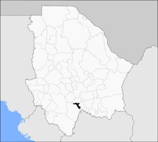
El Tule is one of the 67 municipalities of Chihuahua, in northern Mexico. The municipal seat is the town of El Tule. The municipality covers an area of 409.4 km2. The municipal seat is El Tule, Chihuahua.

The Ninth Federal Electoral District of Chihuahua(IX Distrito Electoral Federal de Chihuahua) is one of the 300 Electoral Districts into which Mexico is divided for the purpose of elections to the federal Chamber of Deputies and one of nine such districts in the state of Chihuahua.

La Manzanilla de La Paz is a town and municipality, in Jalisco in central-western Mexico. The municipality covers an area of 134 km². As of 2020, the municipality had a total population of 4,099.

Tomatlán is a town and municipality, in Jalisco south of Cabo Corrientes in central-western Mexico. The municipality covers an area of 3,015 km2.

The Tule River Indian Tribe of the Tule River Reservation is a federally recognized tribe of Native Americans. The Tule River Reservation is located in Tulare County, California. The reservation was made up of Yokuts, about 200 Yowlumne, Wukchumnis, and Western Mono and Tübatulabal. Tribal enrollment today is approximately 1,857 with 1,033 living on the Reservation.

Tulcingo (municipality) is a town and municipality in the Mexican state of Puebla in south-eastern Mexico.

Centro District is located in the Valles Centrales Region of the State of Oaxaca, Mexico. The district includes the state capital Oaxaca and satellite towns. The district has an average elevation of 1,550 meters. The climate is mild, with average temperatures ranging from 16°C in Winter to 25°C in spring.
El Tule, also known as Craig, is a populated place situated in Apache County, Arizona, United States. It has an estimated elevation of 5,928 feet (1,807 m) above sea level.
La Tulevieja, is a legendary figure from Costa Rican and Panamanian folklore. She is a ghost who wears a distinctive hat called a tule.
| | This article about a location in the Mexican state of Chihuahua is a stub. You can help Wikipedia by expanding it. |
Chihuahua (capital) | ||
| Cities |  | |
| Municipalities | ||
| Metropolitan areas | ||
| History | ||
| Sights | ||
| Other topics | ||