
Elk River is a city and the county seat of Sherburne County, Minnesota, United States, approximately 34 miles northwest of Minneapolis. It is situated at the confluence of the Mississippi and Elk Rivers. The population was 25,835 at the 2020 census, making Elk River the second largest city with an area of 42.33 square miles in the Central Minnesota region after St. Cloud. It is the county seat. U.S. Highways 10 and 169 and State Highway 101 are three of the main routes in Elk River, and a station on the Northstar Commuter Rail line to downtown Minneapolis is located in the city. Elk River is located 33.2 miles northwest of Minneapolis and 37.4 miles southeast of St. Cloud.

The Chicago Water Tower is a contributing property and landmark in the Old Chicago Water Tower District in Chicago, Illinois, United States, that is listed on the National Register of Historic Places. Built to enclose the tall machinery of a powerful water pump in 1869, it became particularly well known when it survived the Great Chicago Fire of 1871, although adjacent buildings burned to the ground.

Black Elk Peak, formerly known as Harney Peak, is the highest natural point in the U.S. state of South Dakota and the Midwestern United States. It lies in the Black Elk Wilderness area, in southern Pennington County, in the Black Hills. The peak lies 3.7 mi (6.0 km) west-southwest of Mount Rushmore. At 7,244 feet (2,208 m), it is the highest summit in the United States east of the Rocky Mountains. Though part of the North American Cordillera, it is generally considered to be geologically separate from the Rocky Mountains.
Prospect Park is a historic neighborhood within the University community of the U.S. city of Minneapolis, Minnesota. The area is bounded by the Mississippi River to the south, the City of Saint Paul, Minnesota to the east, the Burlington Northern railroad yard to the north, and the Stadium Village commercial district of the University of Minnesota to the west. The neighborhood is composed of several districts which include the East River Road area. The 1913 Prospect Park Water Tower is a landmark and neighborhood icon.

Minneapolis is officially defined by its city council as divided into 83 neighborhoods. The neighborhoods are historically grouped into 11 communities. Informally, there are city areas with colloquial labels. Residents may also group themselves by their city street suffixes: North, Northeast, South, and Southeast.

Charles A. Lindbergh State Park is a 569-acre (2.3 km2) Minnesota state park on the outskirts of Little Falls. The park was once the farm of Congressman Charles August Lindbergh and his son Charles Lindbergh, the famous aviator. Their restored 1906 house and two other farm buildings are within the park boundaries. The house, a National Historic Landmark, and an adjacent museum are operated by the Minnesota Historical Society, known as the Charles Lindbergh House and Museum. Three buildings and three structures built by the Works Progress Administration in the 1930s were named to the National Register of Historic Places. These buildings include a picnic shelter and a water tower, built in the Rustic Style from local stone and logs, and have remained relatively unchanged since construction. Although the property includes shoreline on the Mississippi River, the Lindbergh family requested that the park not include intensive use areas for swimming or camping, so development was kept to a minimum.

This is a list of sites in Minnesota which are included in the National Register of Historic Places. There are more than 1,700 properties and historic districts listed on the NRHP; each of Minnesota's 87 counties has at least 2 listings. Twenty-two sites are also National Historic Landmarks.

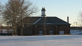
Endion station is a former train station in Duluth, Minnesota, United States. It was built in 1899 to serve the Endion neighborhood but was relocated to Canal Park in 1986 to make way for expansion of Interstate 35. Passenger service through the station had ceased in 1961 and freight service in 1978.

This list is of the properties and historic districts which are designated on the National Register of Historic Places or that were formerly so designated, in Hennepin County, Minnesota; there are 194 entries as of November 2024. A significant number of these properties are a result of the establishment of Fort Snelling, the development of water power at Saint Anthony Falls, and the thriving city of Minneapolis that developed around the falls. Many historic sites outside the Minneapolis city limits are associated with pioneers who established missions, farms, and schools in areas that are now suburbs in that metropolitan area.

This is a list of the National Register of Historic Places listings in Goodhue County, Minnesota. It is intended to be a complete list of the properties and districts on the National Register of Historic Places in Goodhue County, Minnesota, United States. The locations of National Register properties and districts for which the latitude and longitude coordinates are included below, may be seen in an online map.

This is a list of the National Register of Historic Places listings in Fillmore County, Minnesota. It is intended to be a complete list of the properties and districts on the National Register of Historic Places in Fillmore County, Minnesota, United States. The locations of National Register properties and districts for which the latitude and longitude coordinates are included below, may be seen in an online map.

Mill City Museum is located in the ruins of the Washburn "A" Mill next to Mill Ruins Park on the banks of the Mississippi River in Minneapolis. The museum, an entity of the Minnesota Historical Society that opened in 2003, focuses on the founding and growth of Minneapolis, especially flour milling and the other industries that used hydropower from Saint Anthony Falls. The mill complex that the museum is within, dates from the 1870s and is listed on the National Register of Historic Places. It is also part of the St. Anthony Falls Historic District and within the Mississippi National River and Recreation Area.

Nerstrand City Hall is a historic city hall building in Nerstrand, Minnesota, United States, constructed in 1908. It was listed on the National Register of Historic Places (NRHP) on April 6, 1982, for having local significance in the theme of politics/government. It was nominated for being representative of Nerstrand's early growth, and for being Rice County's best example of municipal buildings of the early 20th century.

The Hollywood Theater is a historic theater building in Minneapolis which is listed on the U.S. National Register of Historic Places. It is located in the Audubon Park neighborhood of Minneapolis.
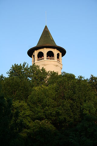
The Prospect Park Water Tower -- sometimes referred to as the Witch's Hat but known locally as Tower Hill Tower or just The Tower -- is a historic water tower in the Prospect Park neighborhood of Southeast Minneapolis, Minnesota, United States. It was built in 1913-1914 on Tower Hill Park, a hilltop park established in 1906. The water tower has become the neighborhood's architectural mascot for its singular design by Frederick William Cappelen. The tower is purported to be the inspiration for Bob Dylan's song "All Along the Watchtower," as the tower was clearly visible from Dylan's home in nearby Dinkytown.
West Washington Street Pumping Station is a historic pumping station located in Indianapolis, Indiana. It was built in 1870, and is a one-story, rectangular brick building. It was modified to its present form after 1909, and is 2/3 of its original size. It has a slate hipped roof topped by a square central tower and features distinctive brick detailing, and arched openings. The building served as the city's only water pumping station until 1890.

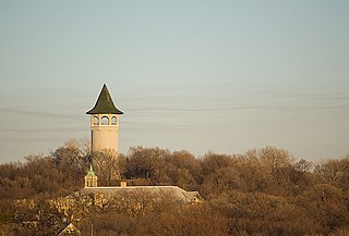
The Ogilvie Watertower is a historic water tower in Ogilvie, Minnesota, United States, built in 1918. It was listed on the National Register of Historic Places in 1980 for having local significance in the themes of engineering and social history. It was nominated for being a rare surviving example of Minnesota's earliest reinforced concrete water towers and a symbol of the local infrastructure improvements that enabled the organization of Ogilvie's fire department.

The Osseo Water Tower in Osseo, Minnesota, is an historic water tower listed in the National Register of Historic Places in June 5, 2017. It was listed for its historical significance to community planning and development in Osseo, because it promoted better fire fighting, provided fresh water to homes and businesses, and supported the growth of the community. It is also architecturally significant because hemispherical-bottom water towers, built from about the 1890s to about 1940, are rapidly being replaced by larger-capacity towers.


