Elkinsville, Indiana

Last updated

Elkinsville, Indiana
Map of Indiana highlighting Brown County.svg
Brown County's location in Indiana
Location map of Brown County, Indiana.svg
Red pog.svg
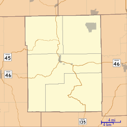
Elkinsville
Location in Brown County
Coordinates: 39°04′34″N86°15′53″W / 39.07611°N 86.26472°W / 39.07611; -86.26472
Country United States
State Indiana
County Brown
Township Van Buren
Founded byWilliam Elkins
Named for William Elkins 1796-1880
Elevation
[1]
581 ft (177 m)
Time zone UTC-5 (Eastern (EST))
  Summer (DST) UTC-4 (EDT)
ZIP code
47448
Area code(s) 812 & 930
FIPS code 18-20782 [2]
GNIS feature ID 450887

Elkinsville is an unincorporated community in Van Buren Township, Brown County, in the U.S. state of Indiana. [3] It was once a thriving farming village, but was evacuated during the construction of nearby Lake Monroe Reservoir by eminent domain in 1964. All that remains of Elkinsville today are some private residences, the Elkinsville Cemetery, and post office. The area is part of Hoosier National Forest.

Contents

History

Elkinsville was founded in the 1850s. [4] It was named for William Elkins, a pioneer settler. [5] A post office was established at Elkinsville in 1860, and remained in operation until it was discontinued in 1941. [6] The town was acquired via eminent domain for the building of Lake Monroe Reservoir in 1964, but later it was discovered that a mistake in elevation estimates meant that the town would not be flooded.

Geography

Elkinsville is located at 39°04′34″N86°15′53″W / 39.07611°N 86.26472°W / 39.07611; -86.26472 .

Related Research Articles

<span class="mw-page-title-main">Monroe County, Indiana</span> County in Indiana, United States

Monroe County is a county in the U.S. state of Indiana. In 1910 the US Census Bureau calculated the nation's mean population center to lie in Monroe County. The population was 139,718 at the 2020 United States Census. The county seat is Bloomington. Monroe County is part of the Bloomington, Indiana, Metropolitan Statistical Area.

<span class="mw-page-title-main">Brown County, Indiana</span> County in Indiana, United States

Brown County is a county in Indiana which in 2020 had a population of 15,475. The county seat is Nashville.

<span class="mw-page-title-main">Monroe Lake</span> Reservoir in Brown and Monroe counties, Indiana, U.S.

Monroe Lake is a reservoir located about 10 miles (16 km) southeast of Bloomington, Indiana, United States. The lake is the largest entirely situated in Indiana with 10,750 acres (43.5 km2) of water surface area spread over the counties of Monroe and Brown. Capacity varies from 292 gigalitres (237,000 acre⋅ft) to 428 gigalitres (347,000 acre⋅ft) depending on water level. It is also home to 13,202 acres (53.43 km2) of protected forest and three recreational areas. Indiana's only federally protected U.S. Wilderness Area, the 13,000-acre (53 km2) Charles C. Deam Wilderness Area, is located on the south shore. The lake's watershed is 441 square miles, 82% of which is forested or farmland. The pool elevation is about 538 feet (164 m) year-round. During colder winters, limited ice fishing is available on protected backwater portions of the reservoir.

<span class="mw-page-title-main">Van Buren Township, Brown County, Indiana</span> Township in Indiana, United States

Van Buren Township is one of four townships in Brown County, Indiana. As of the 2020 census, its population was 1,903 and it contained 888 housing units. The township includes the southern portion of Brown County State Park.

<span class="mw-page-title-main">Benton Township, Monroe County, Indiana</span> Township in Indiana, United States

Benton Township is one of eleven townships in Monroe County, Indiana, United States. As of the 2010 census, its population was 3,358 and it contained 1,716 housing units.

<span class="mw-page-title-main">Bloomington Township, Monroe County, Indiana</span> Township in Indiana, United States

Bloomington Township is one of eleven townships in Monroe County, Indiana, United States. As of the 2010 census, its population was 44,167 and it contained 15,346 housing units.

<span class="mw-page-title-main">Clear Creek Township, Monroe County, Indiana</span> Township in Indiana, United States

Clear Creek Township is one of eleven townships in Monroe County, Indiana, United States. As of the 2010 census, its population was 5,000 and it contained 2,674 housing units.

<span class="mw-page-title-main">Perry Township, Monroe County, Indiana</span> Township in Indiana, United States

Perry Township is one of eleven townships in Monroe County, Indiana, United States. As of the 2010 census, its population was 50,673 and it contained 24,194 housing units.

<span class="mw-page-title-main">Polk Township, Monroe County, Indiana</span> Township in Indiana, United States

Polk Township is one of eleven townships in Monroe County, Indiana. As of the 2010 census, its population was 360 and it contained 195 housing units. It is one of the least densely-populated townships in the state; this is largely because most of the land is occupied by Lake Monroe, the Hoosier National Forest, and seasonal homes and attractions.

<span class="mw-page-title-main">Salt Creek Township, Monroe County, Indiana</span> Township in Indiana, United States

Salt Creek Township is one of eleven townships in Monroe County, Indiana, United States. As of the 2010 census, its population was 1,513 and it contained 822 housing units.

<span class="mw-page-title-main">Van Buren Township, Monroe County, Indiana</span> Township in Indiana, United States

Van Buren Township is one of eleven townships in Monroe County, Indiana, United States. As of the 2010 census, its population was 11,981 and it contained 5,347 housing units.

<span class="mw-page-title-main">Washington Township, Monroe County, Indiana</span> Township in Indiana, United States

Washington Township is one of eleven townships in Monroe County, Indiana, United States. As of the 2010 census, its population was 2,029 and it contained 882 housing units. The township contains a portion of the Morgan-Monroe State Forest.

<span class="mw-page-title-main">Mechanicsburg, Boone County, Indiana</span> Unincorporated community in Indiana, United States

Mechanicsburg is an unincorporated community in Washington Township, Boone County, in the U.S. state of Indiana.

Twin Beach is an unincorporated community in Posey Township, Clay County, Indiana. It is part of the Terre Haute Metropolitan Statistical Area.

Hadley is an unincorporated community in Marion Township, Hendricks County, Indiana.

Hazelwood is an unincorporated community in Liberty Township, Hendricks County, Indiana.

Hyndsdale is an unincorporated community in Jefferson Township, Morgan County, in the U.S. state of Indiana.

<span class="mw-page-title-main">Jordan, Owen County, Indiana</span> Unincorporated community in Indiana, United States

Jordan is an unincorporated community in Morgan Township, Owen County, in the U.S. state of Indiana.

Freeman is an unincorporated community in the center of Clay Township, Owen County, in the U.S. state of Indiana. It lies near the intersection of County Road 650 South and Indiana Highway 43, which is a community nearly nine miles south of the city of Spencer, the county seat. Its elevation is 541 feet (165 m), and it is located at 39°11′44″N86°44′1″W.

Lewisville is an unincorporated community in the northeast corner of Harrison Township, Owen County, in the U.S. state of Indiana. It lies near the intersection of County Road 700 East and West Lewisville Road, which is a community about twenty miles northeast of the city of Spencer, the county seat. This community lies on the border of Owen County and Morgan County.

References

  1. "US Board on Geographic Names". United States Geological Survey. October 25, 2007. Retrieved January 31, 2008.
  2. "U.S. Census website". United States Census Bureau . Retrieved January 31, 2008.
  3. "Elkinsville, Indiana". Geographic Names Information System . United States Geological Survey . Retrieved March 8, 2020.
  4. Blanchard, Charles (1884). Counties of Morgan, Monroe and Brown, Indiana: Historical and Biographical. F.A. Battey & Company. pp.  753.
  5. Baker, Ronald L. (October 1995). From Needmore to Prosperity: Hoosier Place Names in Folklore and History . Indiana University Press. p.  123. ISBN   978-0-253-32866-3. The village was named for William Elkins, first settler and founder.
  6. "Brown County". Jim Forte Postal History. Archived from the original on September 3, 2014. Retrieved August 28, 2014.