Elphinstone, East Lothian

Last updated

Elphinstone
Main Street, Elphinstone - geograph.org.uk - 4341910.jpg
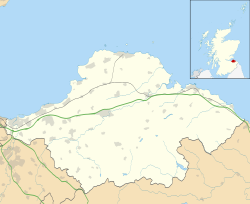
East Lothian UK location map.svg
Red pog.svg
Elphinstone
Scotland location map.svg
Red pog.svg
Elphinstone
Location within Scotland
Population590 (mid-2020 est.) [1]
OS grid reference NT396702
Council area
Lieutenancy area
Country Scotland
Sovereign state United Kingdom
Post town TRANENT
Postcode district EH33
Dialling code 01875
Police Scotland
Fire Scottish
Ambulance Scottish
UK Parliament
Scottish Parliament
List of places
UK
Scotland
55°55′19″N2°57′58″W / 55.922°N 2.966°W / 55.922; -2.966

Elphinstone is a village in East Lothian, Scotland, southwest of Tranent. The ruins of Elphinstone Tower, the former seat of the Elphinstone family, lie nearby.
Contents

Etymology

The village's name was first recorded in the 13th century. [2] It may mean "estate belonging to Ælfwine", from Old English Ælfwinestun. [3] A local fairy tale offers a more fantastical origin for the name, tracing it back to an elf who was imprisoned in stone by a witch whom he had crossed. [4]

History

The Protestant reformer George Wishart was brought to Elphinstone by Patrick Hepburn, 3rd Earl of Bothwell en route to St Andrews where he was tried and burned at the stake on 1 March 1546. [5]

Between 2011 and 2018 the population of the village increased from 520 to 590 [6] and it has basic amenities, including a primary school, a community centre, a newsagent, and a miners welfare club. [7]

Landmarks and economy

The remains of Elphinstone Tower Remains of Elphinstone Tower (geograph 1961775).jpg
The remains of Elphinstone Tower

Located half a mile west of the village, Elphinstone Tower, built in the 13th to 15th century, is a former five-storey tower, now a ruin, with only the lower level remaining. [8] The Elphinstone clan held the lands of Elphinstone and took their name from their lands. [9]

Mines owned by the Edinburgh Colliery Company, Limited were formerly the main employer in the village. Many of the houses in the village were owned by the company. [10] now Inveresk Research International is one of the main employers in the area.[ citation needed ] Elphinstone Tower Farm produces cereal crops. [11]

Related Research Articles

<span class="mw-page-title-main">East Lothian</span> Council area of Scotland

East Lothian is one of the 32 council areas of Scotland, as well as a historic county, registration county and lieutenancy area. The county was called Haddingtonshire until 1921.

<span class="mw-page-title-main">George Wishart</span> 16th-century Protestant martyr

George Wishart was a Scottish Protestant Reformer and one of the early Protestant martyrs burned at the stake as a heretic.

<span class="mw-page-title-main">Uphall</span> Human settlement in Scotland

Uphall is a village in West Lothian, Scotland. It is a swiftly growing village in a conurbation with Broxburn to the east, Dechmont to the west and the major town of Livingston to the south west. Uphall is 30 miles from Glasgow and 14 miles from Edinburgh in the Scottish Lowlands. Uphall Station and Pumpherston are separate villages that lie to the south of Uphall.

<span class="mw-page-title-main">Cockenzie and Port Seton</span> Town in East Lothian, Scotland

Cockenzie and Port Seton is a unified town in East Lothian, Scotland. It is on the coast of the Firth of Forth, four miles east of Musselburgh. The burgh of Cockenzie was created in 1591 by James VI of Scotland. Port Seton harbour was built by the 11th Lord Seton between 1655 and 1665.

<span class="mw-page-title-main">Tranent</span> Town in East Lothian, Scotland

Tranent is a town in East Lothian, in the south-east of Scotland. The town lies 6 miles from the boundary of Edinburgh, and 9.1 miles from the city centre. It lies beside the A1 road, the A1 runs through the parish splitting the parish from its associated villages and hamlets namely Meadowmill and the port of the parish Cockenzie. The original main post road ran straight through the town until the new A1 was built. Built on a gentle slope, about 90 metres (300 ft) above sea level it is one of the oldest towns in East Lothian. The population of the town is approximately 12,140, an increase of over 4,000 since 2001. Tranent was formerly a major mining town, but now serves as a commuter town for Edinburgh.

<span class="mw-page-title-main">Pencaitland</span> Village in East Lothian, Scotland

Pencaitland is a village in East Lothian, Scotland, about 12 miles south-east of Edinburgh, 5 mi (8 km) south-west of Haddington, and 1 mi (2 km) east of Ormiston.

<span class="mw-page-title-main">Ormiston</span> Village in East Lothian, Scotland

Ormiston is a village in East Lothian, Scotland, near Tranent, Humbie, Pencaitland and Cranston, located on the north bank of the River Tyne at an elevation of about 276 feet (84 m).

<span class="mw-page-title-main">Macmerry</span> Village in East Lothian, Scotland

Macmerry is a village located on the old A1 just east of Tranent.

<span class="mw-page-title-main">Torphichen Preceptory</span> Church in West Lothian, United Kingdom

Torphichen Preceptory is a church in the village of Torphichen, West Lothian, Scotland. It comprises the remains of the preceptory (headquarters) of the Knights Hospitaller of the Order of St John of Jerusalem in Scotland. The placename may be Gaelic in origin, e.g., "Tóir Féichín" or Brythonic, e.g., modern Welsh "tref fechan". The name "Tóir Féichín" with its Gaelic reference to the Boundary/Sanctuary stones set one mile around the village is most likely the true meaning of the village and Preceptory name rather than the modern Welsh which has no historical precedent that overrides the true meaning of those Neolithic sanctuary stones.

<span class="mw-page-title-main">Prestonpans</span> Human settlement in Scotland

Prestonpans is a small mining town, situated approximately eight miles east of Edinburgh, Scotland, in the council area of East Lothian. The population as of 2020 is 10,460. It is near the site of the 1745 Battle of Prestonpans. Prestonpans is "Scotland's Mural Town", with many murals depicting local history.

<span class="mw-page-title-main">Wallyford</span> Village in East Lothian, Scotland

Wallyford is a village near Musselburgh and approximately seven miles (11 km) east of Edinburgh in East Lothian, Scotland.

<span class="mw-page-title-main">East Saltoun and West Saltoun</span> Human settlement in Scotland

East Saltoun and West Saltoun are separate villages in East Lothian, Scotland, about 5 miles south-west of Haddington and 20 miles east of Edinburgh.

<span class="mw-page-title-main">Clan Elphinstone</span> Lowland Scottish clan

Clan Elphinstone is a Lowland Scottish clan.

<span class="mw-page-title-main">Fa'side Castle</span> Building in East Lothian in Scotland

Fa'side Castle (Faside Estate) has previously been known as Fawside, Falside, Ffauside, Fauxside, or Fawsyde and is a 15th-century keep located in East Lothian in Scotland. The castle is approximately 2 miles (3 kilometres) southwest of Tranent, and 2 mi (3 km) southeast of Musselburgh. The building was restored in the 1980s and is now protected as a category B listed building.

<span class="mw-page-title-main">Preston Tower, East Lothian</span> Ruined keep in East Lothian, Scotland

Preston Tower is a ruined L-plan keep in the ancient Scottish village of Prestonpans. It is situated within a few metres of two other historic houses, Hamilton House and Northfield House.

<span class="mw-page-title-main">Carberry Tower</span> Building in East Lothian, Scotland

Carberry Tower is a historic house in East Lothian, Scotland. The house is situated off the A6124 road, 2 miles (3.2 km) south-east of Musselburgh. Carberry, like Musselburgh is in the parish of Inveresk. It is protected as a Category B listed building.

<span class="mw-page-title-main">Winton Castle</span>

Winton Castle is a historic building set in a large estate between Pencaitland and Tranent in East Lothian, Scotland. The castle is situated off the B6355 road approximately 0.5 miles (0.80 km) north of Pencaitland at grid reference NT437694.

<span class="mw-page-title-main">Elphinstone Tower (East Lothian)</span>

Elphinstone Tower is a ruined 13th–15th century keep, about 4 miles (6.4 km) south east of Tranent, East Lothian, Scotland, and 0.5 miles (0.80 km) west of the village of Elphinstone, East Lothian.

The Buttercup Dairy Company was a Scottish dairy products company founded in 1904 by Scottish business entrepreneur Andrew Ewing (1869-1956). The company sold condensed milk, eggs, butter, and margarine in its stores; by the 1920s, it had over 250 branches in Scotland and founded a poultry farm located in Clermiston. The poultry farm owned over 200,000 hens and was affectionately known as "Hen City". The company mostly hired women to staff its stores and farm and required them to adhere to a dress code.

References

  1. "Mid-2020 Population Estimates for Settlements and Localities in Scotland". National Records of Scotland. 31 March 2022. Retrieved 31 March 2022.
  2. Black, George F. (1971) [1946]. The Surnames of Scotland: Their Origin, Meaning, and History. New York Public Library. p. 244. ISBN   0-87104-172-3.
  3. Harrison, Henry (1996) [1912]. Surnames of the United Kingdom. Baltimore: Clearfield Company. p. 134. ISBN   0-8063-0171-6.
  4. Tim Porteous (15 September 2018). "Tim's tales: The origin of 'Meg's Chuck' in Elphinstone". East Lothian Courier. Retrieved 1 March 2020.
  5. R W Cargill. "Torchbearers of the Truth: George Wishart (1513-1546)". Believers' Magazine. John Ritchie Ltd. Retrieved 1 March 2020.
  6. "Elphinstone in East Lothian (Scotland)". www.citypopulation.de. Retrieved 1 March 2020.
  7. "Tranent and Elphinstone Community Action Plan 2014-1019" (PDF). www.coalfieldsregen.co.uk. Retrieved 1 March 2020.
  8. "Elphinstone Tower". Historic Environment Scotland. Retrieved 1 March 2020.
  9. "Elphinstone". Scotweb Marketing Ltd. Retrieved 1 March 2020.
  10. "Lothians Housing Evidence given by Robert Brown". Scottish Mining Website. Retrieved 1 March 2020.
  11. "Elphinstone Tower farm" (PDF). Savills. Retrieved 1 March 2020.